Monday, December 16, 2019

2018-03-04: Geocaching in a Historic Cemetery, a Texas Courthouse, and more.

My AwayWeGo Geocaching Adventure for another 360+ Sunday drive from Killeen to Monahans, Texas, has me visiting the Lampasas cemetery, a courthouse, and some other roadside geocaches. Before I get started, a reminder that you can now subscribe to the blog using the buttons on the right side column. Or follow me on my Facebook Page to keep updated with new blogs and other photos not in the blogs.

The first geocache was "A Dollar for a quick fix" (GC3PHKR). A simple urban LPC right there in Killeen to boost my cache distance stats.

Now off to Lampasas and the Oak Hill Cemetery that has three geocaches (GC15HQG, GC17WD6, GC17WGT). From the historical marker: Hartwell Fountain sold ten acres of land to the city of Lampasas in 1872 to establish this cemetery. Originally known as City Cemetery. It was renamed Oak Hill Cemetery in 1908. The Ladies Cemetery Association, A group of concerned Lampasas women, maintained the cemetery from 1891 to 1948, when the city assumed responsibility. Among those buried here are local pioneers, prominent business people, veterans of wars including the Texas Revolution and the Civil War, and their descendants.

It's a huge cemetery with over 7,000 internments making it the largest and one of the oldest in the county. These are just a couple of the beautiful large statues and tombs.


One of the notable buried here is James Jackson Beeman (Dec 21, 1816 - Dec 7, 1888). He was one of the first settlers in Dallas and Weatherford. Born in Madison County, Illinois; came to Texas in 1840. He helped cut the first road in Trinity Bottoms, named Turtle Creek (1841), and plat the city of Dallas in 1842. He guided Texas President Sam Houston to Indian Parley in 1843; Joined California Gold Rush in 1849; pioneered Parker County in 1854; and aided in the rescue of Comanche captive Cynthia Ann Parker in 1860. Returned to Dallas to live in 1864 and died in Lampasas in 1888.


After nearly an hour wondering the cemetery looking at headstones, I was one my way. Stopped briefly at a roadside geocache called "I wish I would have listened" (GC24X6Y).

Then passing through the small town of Rochelle, I went over to the cemetery. However there were some muggles (non-cachers) visiting. There wasn't a geocache there so I just did a quick drive through to look at hiding place possibilities before leaving. Driving by the school getting back to US-190, I saw the sign that clearly explains how rural Texans deal with those who have bad intentions.


Upon arriving in San Angelo, I decided to stop for a Starbucks coffee. Around the corner I figured I'd grab a quick geocache at a Chinese restaurant. The cache was called "Dog" (GC728PN). It is named for a symbol on the Chinese Zodiac, NOT a menu item. I spent about 15 minutes looking in some bushes at the corner of the parking lot near the road. I hate shrub hunts. Probably my least favorite, especially along a busy street. Making it worse was that I couldn't find it. So a DNF for today.

Next up was the town of Mertzon in Irion County. The geocache was located out front of the Irion County Courthouse (GC167F1). Now I think I've read somewhere that this was voted as the ugliest County Courthouse in Texas, but don't hold me to it. Compared to the previous courthouse over in Sherwood, this one is pretty boring. But that's the way it goes when the railroad decides to stop in one town over the other.


One quick final roadside geocache stop at "17thBava3" (GC3M804) for mileage just past Crane and finishing up back in Monahans. That's it for today. Thank you for riding along. Hope to see you back again soon.

Thursday, December 12, 2019

2018-02-25: Geocaching Through Texas Cemeteries and History

Today's another Sunday which means another 360+ mile Sunday drive from Killeen to Monahans, Texas. Not a whole lot today. Just five geocaching finds and one hide. But some interesting history. So have a seat on this cool bench that I saw today and ride along with me.


My first geocache was called "Back At The Barnyard" (GC3FY0R). It was a quick roadside cache on a side street in Kempner. Going beyond that just up the road was the Kempner Cemetery. It didn't have a geocache hidden there, so I hid one myself: GC7JTPF. The town of Kempner moved a number of times during its early years of development. It was first settled in the early 1850’s, when a number of families named Pickett moved to the area, which became known as Pickett Valley. The community was also briefly known as Brummersville during 1865. Around 1854 Dan W. Taylor moved to the area with a large herd of cattle and built a store for his men on Taylor Creek, two miles from the present town site. A post office named Taylor’s Creek was established in his store in 1873.

The area was rowdy and lawless in its early days. There was considerable Indian trouble. Taylor asked Governor F.R. Lubbock for ammunition to help the settlers hold their own against the Comanche, but Lubbock wrote back that he and his neighbors should contact a man named Mr. Foster in Burnet for their gunpowder. As if that wasn’t bad enough, several stagecoach and mail robberies occurred between Taylor’s Creek and Belton. After Taylor’s death, the state sent Texas Rangers to the area. The crimes changed from Indian raids and stagecoach robberies to more common acts of the day: unlawful card playing, dogging hogs, maliciously killing dogs, disturbing the peace by using unbecoming or vulgar language in public places, such as the post office and churches, the unlawful carrying of pistols and fighting.

After Mr. Taylor’s death the community was named after a local landowner named Phillip Slaughter. The Taylor’s Creek post office was discontinued in 1878, and that same year a post office named Slaughtersville was established. In 1882 the Gulf, Colorado and Santa Fe Railway was built through the area, two miles from the Taylor store, and the community’s center finally became fixed when the post office was moved to a frame building near the railroad tracks and renamed Kempner after Harris Kempner, a Galveston merchant and director of the Gulf, Colorado and Santa Fe. The coming of the railroad caused the population to double. By 1884 Kempner had two steam gristmills and cotton gins, a church, a district school, and telegraph service, and by 1896 a hotel had been built. Telephone service was available by 1914.

The population of Kempner remained at an estimated 103 from 1904 to 1926. It rose briefly to 300 in 1927 but began to drop again in the 1930’s, reaching 125 in 1933 and remaining at that level for a number of years. It began to rise again in the mid-1960’s until it reached 420 in 1974, where it remained through 1990. Nine businesses were reported in 1986. By 2000 the population was 1,004 with fifty-four businesses.

The photo below is the grave site of George Waters who died January 26, 1882, at age 26. He was the first to be buried in the Kempner Cemetery.


Continuing west on US-190, I came to my next geocache and cemetery. "HPHR Senterfitt" (GC1E1FE) is where Reuben S Senterfitt came to this area near Lometa in the 1860's. A town named for him gradually built up and at its peak boasted hotels, mills, stores, saloons, a school, churches, a stage stop, and this cemetery. The town declined after it was bypassed by the railroad in the 1890's. The cemetery contains the graves of many early settlers. The oldest documented burial here is that of Joseph C Howell, who died in 1877 at the age of 3. Also interred here are veterans of the Civil War, World War I, World War II, and Vietnam.

When I saw this headstone in the cemetery, my first thought was "Who is John Galt?"


Before getting into San Saba, there's a bridge crossing the Colorado River. On the eastern edge you'll find my next geocache and a historical marker. Chadwick's Mill (GC17WEN) was a famous pioneer sawmill, flour mill, and cotton gin. Built 1874 by Henry A Chadwick and son Milam. A sturdy oak dam across the river supplied power. A millrace chiseled in sandstone channeled water to millstones. Mill and gin house were also sandstone. A fish trap in Millrace offered food and sport to customers who often had to wait several days for a turn at the mill.

This scenic spot grew to be a popular resort around 1900, with hotel and dance platform, attracted hundreds of campers. Change in course of river in 1915 forced mill to be abandoned.


Now on US-87 almost to San Angello, I stop for two geocaches near the town of Wall. The first cache was at the "Wall Cemetery" (GC18HA4). Wall, Texas, was originally called Lipan School, then Little School, then Murray's Store. The area was a school district covering 326 square miles, which was reduced to 237 square miles in 1889. The first settlers were J. C. and Lou Bell Bunnell in 1886. The town was named for J. M. Wall, a storekeeper who served as first postmaster; the post office opened in 1906. Wall served as the trading center for the fertile Lipan Flat region, where cotton and grain are grown. The town supports several businesses and a school. The population was 250 in 1920, 120 in 1930 and 1947, and 200 in 1980 through 2000.


About a mile or so to the south, is the entrance to what used to be an auxiliary air field for what was then "Goodfellow Field". Goodfellow Air Force Base now. In it's day, Goodfellow Field trained pilots and this was one of the major (paved) aux airfields used in the pilot training. The skies around San Angelo were full of buzzing little blue and yellow trainer aircraft. The planes were slow compared to what they have now. Later this became the entrance to the Wall Drag strip on the old runways. They raced cars here for fifty years. Now only the gates and a geocache are left (GCNRQB).

A quick stop for food and gas in San Angelo, then it was just driving the rest of the way. I hope you enjoyed my Sunday drive. Be sure to subscribe or Follow me using the buttons to the right. Or "Like Me" at the Away We Go Facebook Page! See y'all next Sunday...

Wednesday, December 11, 2019

2018-02-18: Geocaching Through Burnet County Texas Cemeteries, Churches, and an Old Bridge

Ah yes, another Sunday and another long drive back to West Texas. Today's Geocaching Adventure route was 381 miles from Killeen to Monahans. But I spent all my time in Burnet County.

My first geocache was called "Our Favorite Bridge" (GC7G5G8). From the historical marker: "The small ghost town community of Joppa was established for a church and school in the 1880's. With the growing population in Burnet County and business generated from the railroad, the county decided to construct several bridges over waterways throughout the nearby communities. On January 27, 1906, a bond election was held and passed to fund the construction of three truss bridges, including one near the Joppa school and church, the only one still standing of this group.

At 136.2 feet, the Joppa iron truss bridge played an important role in the everyday lives of many families in the Joppa Community. Traveling to neighboring towns to conduct business was simplified. In addition, life on the river and under the bridge was a large form of entertainment and relaxation during the Great Depression and WWII. Access to education also greatly improved with the construction of the Joppa Bridge. Before 1900, young people in rural areas were mostly limited to elementary and/or junior high education. With improved roads and transportation, greater opportunities were available."

I don't know about you, but I like old bridges. I'm glad they didn't tear this one down when the new modern bridge was built next to it.


As mentioned above, the Joppa Church was close by and was the location of my next geocache "Cache Wars: Joppa the Hut" (GC1RX74). From the Handbook of Texas Online:  Joppa was first called Pool Branch, after a nearby pool formed by a waterfall. At that pool in the 1880's were a cotton gin and a mill; just southeast of the gin were a store and a blacksmith shop. On August 31, 1881, J. S. and Jane Danford of Delaware County, Iowa, gave two acres of land on the north bank of the North Gabriel to be held in trust for a school and a church. The school building was constructed at once and used for classes and church services. Worship was held in the schoolhouse until 1913, when a church building was erected.

The local school, the church, and the locality were called Pool Branch until 1891, when the community secured a post office, and the people agreed on the Biblical name Joppa. On May 19, 1904, a telephone line was installed in Joppa. An iron bridge was built across the San Gabriel River in 1907 and was still in use in 1989. The area received electricity in 1939 from the Pedernales Electric Cooperative. The school was consolidated with the Bertram district in 1942. Friday and Saturday night socials and Sunday night singings culminated in an annual picnic as late as the 1930's. The church and school buildings were still used in the 1980's for church and community activities. In 2000 the population was thirty-four.


A couple of turns to the west and I arrive at my next geocache and somewhat of a roadside attraction. "Have Fun Storming the Castle" (GC43FTM) looks almost like a grain silo that has been done up to look like a castle. But you can tell that it's definitely not a silo. It was too far in the distance to get a decent pic with my phone though. If you click on the link to the cache page, there's a photo of it in the gallery.

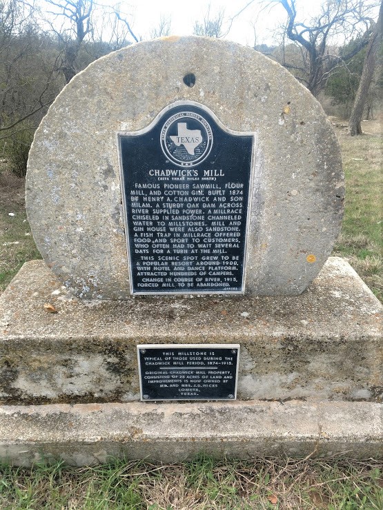
A short drive down a country road and I arrive in Shady Grove for my next two geocaches. From the historical marker: The community of Shady Grove (GC20TXN) was settled in the 1850's and 60's by families on this farm and ranch land along the middle Gabriel River. The old Austin-Lampasas and Burnet-Belton roads intersected here. At first the community was called "Russell-Gabriel." The Cumberland Presbyterian Church organized and met in the school building in 1878. Soon the name changed to Grove because the schoolhouse was located in a grove of live oak trees.

The settlement boasted a cotton gin and corn mill, a general store and blacksmith shop, a doctor and a masonic lodge. In 1882 the Presbyterian, Methodist, and Baptist congregations built a union arbor for camp meetings and revivals. For a few months in 1902 there was a post office. Since there was another Shady Grove in Texas, the name "Tamega" was used. A general store by that name operated here for 50 years.

The Presbyterian fellowship erected this church structure first and then in 1905 built this tabernacle. The school consolidated with Bertram in 1942. When the Presbyterian congregation merged with Bertram in 1966, this property became a community center and homecoming site.


Over in the Shady Grove Cemetery is my next geocache called "Heartfelt" (GC213F4). A Shady Grove Cemetery Association was established in 1958. In 1968, the association secured title to the land, church, and tabernacle. According to Find-A-Grave.com, the oldest marked grave dates back to 1879. The cache itself is kinda cool. Not near a grave site so not to be confused with decoration.


Just north of Shady Grove was another ghost town by the name of Strickling. There wasn't a geocache there, but I went and checked out the cemetery anyway. From Texas Handbook Online: John Webster received a land grant on the Charles Cavenah survey, but when his party arrived in the area in 1839, they were attacked by Comanches. The men in Webster's group were killed, and his wife and two children were captured and held for several months. In 1852, Webster's daughter Martha claimed his land as his sole heir, and the next year she married Marmaduke Strickling (sometimes spelled Strickland or Stricklinge). The developing settlement took that name.

The community became a regular stage stop on the Austin to Lampasas route, and a post office was established in 1857. A school, a church, and several businesses prospered during the years that the town was on a major transportation route, but in the 1880's a decline began. The Austin and Northwestern Railroad bypassed Strickling in 1882, and when the stage line was discontinued later that decade, the town lost much of its vitality. Its population was reported as sixty in 1884 and in 1890, but by the mid-1890's its post office had been discontinued, and most of its residents had moved away. By 1900 the last store had closed. A cemetery was all that marked the site on county highway maps in the 1980's. The oldest marked grave is that of David Chapman Jones (1830-1869).

Hopefully it's the foot and not the head!

Then I went over to Pleasant Hill Cemetery for my next geocache (GC46WPC). I couldn't find much history other than it was established in 1887. There are about 340+ internment here and is still used by the few locals in the area.


My last geocache for the day was at another cemetery. "Ancient LehteB Grave" (GC22V7B) was at the Bethal Cemetery. From the historical marker: The REV. Richard Howard (1817 - 1882) moved to this area of Burnet County in 1885. The frontier settlement he joined would later be known as the Bethel Community. In 1874 he deeded two acres at this site for the community use. The first recorded burial was that of Howard's Grand-daughter, Harriet Ruthie Howard, in 1875. Since then this site has been used as the Bethel Community Cemetery. Buried here are veterans of the Civil War to World War II and many of the area's early settlers and their descendants. The Bethel Cemetery Association was established in 1930.

The one grave that caught my eye was the Hudgins grave site. Of the hundreds of cemeteries I've been to, and the many different decorations, this is the first time seeing a telephone. I guess that's one way to communicate without seeing a psychic or performing a seance!


Wow, I've spent this whole time caching around Burnet County. I still got over 300 miles to drive. Gotta get moving. No more caches the rest of the way.

By the way, along with the Facebook Page with which you can follow me on, I've added the Follow or Subscribe buttons over to the right side of the blog page. If you're viewing on a laptop or tablet. Not sure how it shows up on a phone. So be sure to Follow, Share, or especially leave a comment or suggestion. I'd like to hear from you. See you next week...

Tuesday, December 10, 2019

2018-02-11: Geocaching Redemption Finding Previous DNF's and More!

Another Sunday and another 360+/- mile drive from Killeen back to Monahans, Texas. And just in case it hasn't hit you yet, depending on whether or night I work a 5-day or 6-day week, I'm driving eastbound after work from the jobsite approximately 320 miles either Friday or Saturday night. So it's a good thing I like driving!

Anyway, today's drive takes me along the same route as last weeks blog. Though I find many new geocaches and redeem two DNF's from last week, placing them in the Found column!

My first stop was confusing to me. I thought I had been there before but it was still showing up as unfound. I pulled up to the "Brown Cemetery" (GC4QKZ8) geocache next to the airport in Killeen and realized that I was already there. I found the geocache again and looked at the logsheet. Sure enough there's my stamp. I even talked about it in my November 18th's Blog, but I guess I forgot to log it as found. I wonder how many other geocaches I forgot to log?

After putting 100 miles behind me, I decided to get these three geocaches lined up on US-283 just north of Brady. "On The Road Again" (GC5E8QY), "Boot Hill" (GC6W393), and "Keeping Boundaries" (GC6W0PX) were all quick roadside caches. I thought Boot Hill might be an old west cemetery, but turned out to be a cemetery of sorts for old boots on fence posts.

Another 100 miles later and I was back in Sherwood, Texas. If you remember from last week's blog, the geocache at the old courthouse "TGT: Sherwood" (GCM4G3) was nowhere to be found. After a conversation with the CO mommio, I got permission to replace it with a Slim Bob cache.


Then I went over to the "Old Cub Scout House" (GC7DXBM) from last week which I could not find. After using a PAF a few days earlier for additional clues, I began the search again. Another 10-15 minutes of looking and finally redeemed last weeks DNF and put this one in the found column.

Passing through Mertzon a little ways, I took a detour on a side road to "Hawt N' Juicy" (GC3CY7Z) cache. It was a quick roadside cache near the bridge over Spring Creek.

My next geocache was a roadside memorial for a "Fallen Hero" (GCWR3Y) on US-67 just east of Rankin. Sammy Charles Long was a Texas State Trooper who was killed on November 21 1976. The suspect was able to gain control of Trooper Long's service weapon and shot him several times. A deer hunter who was returning home witnessed the murder and shot and killed the suspect using his hunting rifle. Patrolman Long had been employed with the Texas Department of Public Safety - Texas Highway Patrol, for 18 years and was stationed at McCamey.


Just down the road is a picnic area and "Another Hero" cache (GC1D7AK). It was at this picnic area that the hunter witness Trooper Long loose his life. Then he became the hero taking action and taking out the suspect.

Entering Rankin once again, I stopped for two more geocaches. First was the "Rankin Museum" (GC3XRA9). Formerly the Yates Hotel, Ira Yates built the 3-story, 46 room, sandy brick hotel in 1927 at the height of the oil boom. It had a restaurant, a drugstore, and a barbershop. The hotel closed in 1964 and remained close for a decade until the Rankin Museum Association converted it into a museum. I invite you to take a look at the Texas Escapes website for some more interesting stories about the hotel. About the famous musicians that played at the "Rankin Beach." Yeah that's right I said BEACH! You gotta read about that too! I tried to get a photo of the interior through the glass. It was closed when I stopped by.


One more geocache at the Rankin sign (GC2M5EY) on the west side of town. That's it for today. Time to head up to Monahans. See you next week...

2018-02-04: Texas Ghost Towns, Cemetery, and Courthouses

Hello again and welcome to another 360+/- mile Sunday Geocaching drive from Killeen to Monahans, Texas. There are multiple routes to take and I will probably be taking most of them over the next few months as I find all the available geocaches. So I hope you'll come back to follow along as I visit a lot of ghost towns, cemeteries, Texas history, and just ordinary roadside geocaches. And just a reminder to like our new Facebook page at https://www.facebook.com/AwayWeGoUS to stay up to date with any new posts.


My first geocache (GC2C3WW) was just several miles away in Copperas Cove, the next town over. Since I'll be making this long drive every weekend for a while, I'm gonna try to grab a cache near to each end. This will help to increase one of my favorite stats: cache-to-cache distance. This stat measures the straight line distance from each found cache in the order that you found them. I started caching back in 2006. From 2007 through 2010, I was an over-the-road truck driver. Caching along the way, I racked up miles quickly that way. I currently have nearly half a million cache-to-cache distance miles. So let's continue rolling!

My next cache was called "Almost There" (GC363HY) located just off US-190 near Rochelle. A quick park-n-grab and I'm on my way.

Over and through San Angelo, I take US-67 south (west). Taking one of the side roads for a short detour, I stopped for the "Don't Get Stuck" geocache (GC11J83). A fairly easy cache to find right along the road. But it hasn't been found in nearly 4 years! So it felt pretty good to have found a lonely cache and still in good shape.


Another side street geocache a few more miles down was the "Big Rock w/Bonus" geocache (GCMF26). This cache was first hidden way back in 2005, thirteen years ago! So the "Bonus" were the coordinates to a puzzle geocache just to the south. So after finding the "Big Rock", I found the puzzle cache called "Foster" (GCMF2D).

Getting back to US-67, but not very far, I arrived at "TGT: Tankersley" (GC15Y5B). Tankersley (Tankersly), also known as MacGrath, was named for Richard Franklin Tankersley, husband of Annie Ellen Allen Tankersley, one of the first white settlers on the Concho River in 1864 and donor of land for the townsite. A post office, established in 1910 as Tankersly, was discontinued in 1963. In 1914 the community had a population of forty, a general store, and two grocers. The local school had eighty-three pupils and three teachers in 1933. The population reached a high of seventy-five in 1946, when Tankersley had three businesses, but by 1953 the community had twenty residents and one business. In the 1980's a cemetery, the Tankersly–Twin Mountain school, the abandoned railroad station, and the West Texas Boys Ranch remained in the area. The estimated population of the community was twenty in 1990. No population estimates were available in 2000.

Close by to Tankersly was "TGT: Hughes" (GC15T5E). Hughes, between Spring Creek and the Middle Concho River in east central Irion County, was named after Duwain E. Hughes, on whose ranch the settlement was located. The Hughes community was receiving its mail from Tankersley in Tom Green County in the early 1950s; the townsite was not shown on later maps.

I didn't see anything to take a photo of near these two caches.

Crossing over into Irion County I arrived in the community of Sherwood. There are three caches here in town. The first geocache was at the Sherwood Cemetery (GC113GK). The oldest dated internment here is Infant Daughter Hodge in 1865. There are also several here that perished in the flood of 1882.


Next up was the beautiful former Sherwood Courthouse (GCM4G3). See photo at top of this page and below. The first permanent courthouse for Irion County, Texas, locally organized in 1889. Replaced temporary housing in several buildings. Site was gift of Mr. and Mrs. Frank Ripley. Contractors Martin and Moody; stone was quarried nearby. Courthouse was used for dances, teachers institutes, community events, and the lawn for summer socials.

In a familiar case of death-by-railroad, Mertzon became the county seat in 1936 and this small town was finished. This was merely a technicality since Sherwood had all but been abandoned when the railroad by-passed it by two miles in 1910. The now privately owned courthouse is available for special events and festivals. The clock faces had painted hands. The hands reportedly indicate the moment of Abraham Lincoln's death.

After spending about 15-20 minutes of looking where there just weren't a whole lot of places to hide it, I did not find the cache. I do not like to, but I had to log a DNF on this geocache.


The last cache in town for me to find is another one of those "would never have seen if it weren't for geocaching" places! This dugout type home was once "The Old Scout House" (GC7DXBM). I couldn't find any information on it other than what's listed on the geocaching page that it was once a cub scout meeting house. Don't know any dates for it. But it does look like it would have been a cool place. After taking a lot of photos and looking into all the cracks and crevasses, I could not find a cache. Ughh! Two DNF's in a row! Not a good sign.


Continuing westbound on US-67, I arrive in the town of Rankin. Established in 1911, Rankin is the oldest town in Upton County and named after rancher F. E. Rankin. The first of two caches in town was "Sitting on a Hilltop" (GC2YC10). Located near the Rankin Park Building and gave you great views of the town.

Next on the north side of town was "Rodeo Kids" (GC3W3NM). Since 1952, the community of Rankin has annually hosted an all-Kid Rodeo. An event unique to the sport, which has it's roots in the American cattle industry. Ranching has been the backbone of the Rankin economy sine the town's establishment in 1911. Many of the cowboys and ranchers in Rankin participated in rodeos, while other individuals from outside the area came here roping events. The competitors often brought their children, many of whom practiced events and wanted an outlet for their skills.

In 1952, professional roper Walton Poage, along with his son and his son's friend, enlisted help from residents in Rankin in creating an all-kid rodeo. The community came together to support the idea and the first all-kid rodeo was held that year in two go-rounds of calf roping, ribbon roping, goat roping, steer riding, and a barrel race and boot scramble. The entry fee for each event was $1.00 and prizes were donated by local businesses and residents. By the next year, the Upton county 4-H club began to sponsor the rodeo. The event grew in popularity, and in 1954, approximately 1,500 to 2,000 individuals attended each night of the event.

Since its inception, the all-kid rodeo has been held every year. It brings commerce into Rankin, drawing in visitors and competitors, many of whom later became members of the professional rodeo cowboys association. It was the first rodeo contest for many boys and girls, and helped them get a start in the sport. Today, the all-kid rodeo continues to be a unique tradition promoting the ranching and family spirit of the Rankin community.

That's all for today. I take the final leg home to Monahans where I can grab a bite to eat and relax. Until next week...