Showing posts with label springs. Show all posts

Sunday, September 3, 2017

2017-07-05: Driving Back to West Texas Day 2: Alabama, Mississippi, Louisiana, and Texas

Welcome back to Day 2 of my road trip from Florida back to West Texas. Today begins in Evergreen, Alabama. After a good nights rest at the hotel and a quick hotel breakfast, it was time to hit the road again. I'm still following the backroads of US-84, trying to stay off the interstates as much as possible. At the same time Geocaching and sightseeing along the way.

My first stop was to get gas and a Geocache (GC2APKW) at the Love's Travel Stop for Conecuh County, Alabama. A quick fuel up and find and I was on my way.

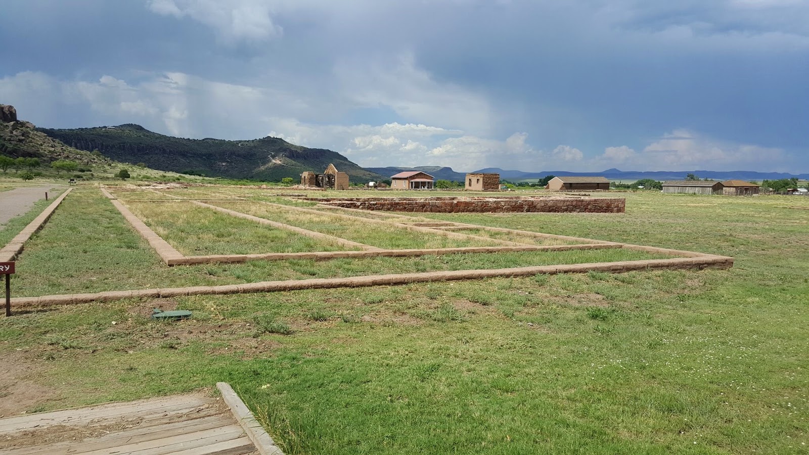
The next county over was Monroe County and also the next cache. The Geocache was by a historical marker for Fort Claiborne (GC178A3). Built by General Ferdinand L. Claiborne during the Creek Indian War of 1813-1814 as a base for his invasion of the Alibamo country with the U. S. Regulators, Lower Tombigbee Militia, and friendly Choctaws. Claiborne's campaign culminated in the American victory over the Creeks at the Holy Ground. I was hoping to see something other than the sign, but nothing of the fort remains.

Moving on to Clarke County and a quick roadside cache stop (GC2MYZ7) to claim a find and to continue making good time.

Choctaw County was the last along US-84 in Alabama and a county needed. I stopped at the Bladon Springs State Park for an Earthcache (GC3JAB8). The springs here, named after the original property owner, James Bladon, were first opened to the public as a therapeutic spa in 1838. Seven years later, state geologist and University of Alabama professor Richard T. Brumby and two colleagues from the University of Louisiana traveled to the springs to conduct a comprehensive analysis. Brumby reported his findings in a 27-page book, "An Analysis of the Bladon Springs," published in 1845. Following the report, the tourist trade increased so much that a resort was built, including a bowling alley, cabins, skating rink, and last but not least, a Georgian Revival hotel that could house 200. The resort is gone, but four springs remain, one of which is still covered by the gazebo from the resort days.

I gathered the information I needed for the earthcache and took a few pictures. There were two more caches in the park and I was tempted to take the short hike after them. But the road ahead was calling and I wanted to get some miles put behind me. So across the state line into Mississippi I went.

Wayne County was up first with a quick roadside cache (GC38PV9). After that was a quick Virtual Cache (GCE7A7) in Jones County. Continuing westbound on US-84, I skipped right through Covington County having already found a cache there. Then quick park and grab roadside caches in the remaining Mississippi counties of Jefferson Davis (GC388J0), Lawrence (GC1RNA2), Lincoln (GC35WGT), Franklin (GC35WGT), and Adams County (GCTV6P).

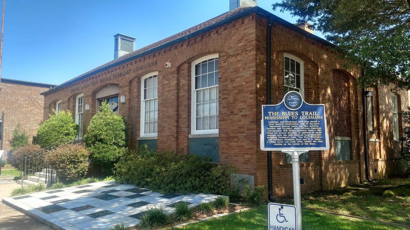
Crossing the state line into Louisiana, they have Parishes instead of counties. My first stop in Concordia Parish is the Delta Music Museum (GC1D5VZ) along the Blues Trail. Louisiana and Mississippi have long shared a close musical relationship. One of the most important musical paths was that between Natchez, MS and Ferriday, LA, where African American entrepreneur Will Haney operated Haney's Big House for several decades. In addition to major national acts the club featured local musicians including Ferriday's Leon "Pee Wee" Whittaker and Natchez's Hezekiah Early and Y. Z. Ealey. A young Jerry Lee Lewis often visited the club, soaking up the sounds of the blues.

I had arrived to the museum just as it was closing up. She watched and we chatted as I searched for and found the Geocache. After signing the log, we went inside and she gave me a quick tour of the museum.

Two more quick caches in LaSalle Parish (GC23AXN) and Natchitoches Parish (GC4XHMC) before arriving in Sabine Parish and a cemetery cache (GC2D9MA). Fender Cemetery has over 300 interments dating back to 1851. One of the spookier graves is of this red brick tomb that seems to have been elevated a few inches. Kinda makes you think that the undead comes crawling out at night searching for innocent victims to carry back to the underworld.


I crossed the Sabine River into Texas at sunset and got a spectacular view. Driving nearly 600 miles today, I've got around 450 miles to go. Can't wait to get home to see my Beautiful Sweet Wife!

Monday, July 4, 2016

2016-06-12: More History, Cemeteries, an Old Fort, and an Oasis in West Texas

Hello again and welcome back to our Geocaching Adventures Blog. We hope you have enjoyed our stories so far and invite you to leave your comments below. Today's Geocaching Adventure has us driving deeper into the South West Texas to find Geocaches in each of the Brewster and Presidio counties. And being Texas where everything is bigger, driving just three counties over to get our first cache and a new county was 98 miles away! So let's get right to it...

Driving south on US 385, the first stop was an Earthcache (GC2KQE0) just north of Marathon, TX. This cache brings you a spot along the side of the highway where you can get a good view of how the earth buckles under the pressure of shifting continental plates.


Continuing south and into the town of Marathon, our next two Geocaches was at the Marathon Cemetery (GC272P8 and GC190F6). According to Albert Chambers, an early resident of Marathon, the first people who were buried in Marathon were six Chinese railroad workers. They were buried on the north side of what later became the Albert Chambers home. This burial site was slightly to the southeast of the Old Chambers Hotel, a local historical building. Mrs. Fannie Harris, a long-time Marathon resident, related that the next burials were south of the old George Harris home in Beakley Draw known as the Village Green. In 1905 a flood displaced many of the graves. Mr. Guy Combs and Mr. W.J. McIntyre donated land south of town for an Anglo cemetery as well as land for a Mexican cemetry. Additional land was donated by the Combs family in 1951. Mr. Lewis Harmon, another early Marathon resident, has stated that the first burial in the new cemetery was a Mr. Quick, although no record of his death has been located. The rock work for the entrance gate and four corner posts was done by L.Cordova in 1933. The plaque on one of the entrance posts was donated by Laura & Thomas B. Henderson. It reads as follows: IN MENORY OF THE DONORS OF THIS LAND Guy S. Combs, Nora C. McGehee, Lila C. Matthews, W.J. McIntyre, 1902 Marathon Cemetery Ass'n 1961.  A recent survey of the Anglo cemetery shows that there are 587 marked graves and approximately 127 unmarked and lost graves. Approximately 12 graves remain in the civilian cemetery at Fort Pena Colorado, and only one grave remains in the military cemetery. Several of the graves from these two cemeteries have been moved elsewhere. Many unknown graves are located on area ranches. No survey has been made of the Mexican cemetery.

A few blocks away was our next stop at the Marathon Oasis (GC22ZR4) located in a park called Gage Gardens. Part of the Gage Hotel and sprawling across 27-acres of lush greens, the Gage Gardens encompasses a native landscaped garden park with lovely ponds, beautiful fountains, nine-hole putting green, rose garden, vineyard, fruit orchard and a large fire pit with banquette seating. Guests can meander around the quarter-mile walking trail through the meticulously landscaped garden or take the more challenging one mile jogging loop with interval exercise stations. Blooming with colorful indigenous plants that flourish year round, the garden is a welcome home for migrating birds and butterflies, and provides the ideal spot for a relaxing walk with your partner or dog, an afternoon picnic, an idyllic wedding or private party.


Speaking of the Gage Hotel, built in 1927 for pioneer Texas rancher Alfred Gage by acclaimed architect Henry Trost and has 15 guest rooms. Next door to the hotel is the Albion E. Shepard House, now restored and owned by the Gage Hotel. In 1883, completion occurred of the extension of tracks by the Galveston, Harrisburg and San Antonio Railway Line located between El Paso and San Antonio. Retired Sea Captain Albion E. Shepard arrived in the region as a railroad surveyor. He acquired much land in the area. Tradition documents the naming of Marathon to Capt Shepards observations of the similarity of the valley and its encircling hills to Marathon, Greece, where the mountains meet the waters of the Mediterranean Sea. At this site, Capt Shepard applied for a Post Office in September 1882 where he became the first postmaster. The Marathon town site was created on December 6, 1885. This two-story home was built by Shepard in 1890 and was later acquired by a neighboring rancher of the Hess Family where it remained until the 1980's. Today it is owned and was restored by the Gage Hotel in 2012, containing five guest rooms in the main house with two rooms in the carriage house out back.


Another building of interest in Marathon is the "Club House." Built in 1888 and was the oldest school house in Brewster County, Texas. It was restored in 1928 and used for all public meetings and all elections.


OK, this was neither a Geocache or nor historical site. Actually I'm not sure what it is other than maybe the first, smallest, and original Target Store. I don't know exactly, but we were driving down the road and there it was out in the middle of nowhere. We just had to do a u-turn and get a photo. Just one of the many things you see while out Geocaching!


The next Geocache was a quick park and grab in a picnic area at the intersection of US-67 and US-90 where there was also a historical sign describing the Flat Rock mountains nearby (GCM38C).

A few miles further down the road was the town of Alpine, TX and our next Geocache (GC47NWN). On September 11, 2001, a ceremony was to be held for the ground breaking of the new building for the United States Border Patrol but was halted due to the 9/11 terror attacks of that day. Ten years later, another ceremony was held unveiling a piece of steel extracted from the rubble at the World Trade Center as a memorial to the victims.


View of the Texas Alpine mountains from the memorial.
Continuing west on US-67/90 for a few miles, we travel through the Paisano Pass and grab our next Geocache (GC478TC). From the historical marker at that site: "Legend recounts that two Spaniards meeting here greeted each other "Mi Paisano" (My Countryman). First known to history when Juan Dominguez de Mendoza camped here on January 3, 1684. Well known after 1850 as a point on the Chihuahua Trail, an emigrant road to California."

Next along the way is a small town called Marfa. We stopped for our next cache (GC2CZ32) at a rest area and viewing spot for the Marfa Lights. The Marfa lights, also known as the Marfa ghost lights, have been observed near U.S. Route 67 on Mitchell Flat east of Marfa. They have gained some fame as onlookers have ascribed them to paranormal phenomena such as ghosts, UFOs, or will-o'-the-wisp, etc. However, scientific research suggests that most, if not all, are atmospheric reflections of automobile headlights and campfires. It was late afternoon when we stopped and the only light we saw was a big ball of fire called the sun.

Heading northbound on our way back home, we stopped by Fort Davis National Park for a quick Virtual Geocache (GC5958). We got there within 30 minutes of closing and storm clouds rolling in. They had just closed the register and we told them we were stopping for the Geocache, so they just let us tour for free. We did a quick 10 minute walk through the grounds and Candy still managed to take 63 photos! And we avoided the rain by just a few minutes after exiting the parking lot.


Further up the road beyond the rain and one last stop at the Balmorhea State Park in Toyahvale, TX to get an Earthcache (GC1W9T6) and a Virtual Cache (GCD374). This place was packed! I think everyone in the county was here on this hot afternoon to cool off in the San Solomon Springs. Again we were only interested in the caches, so we informed the front gate upon arrival and they just let us pass without paying the entry fee. And again after 10-15 minutes we had the required answers and on our way.

Well that's it for today. Thanks for following along and we'll see you next time out on the Geocaching Trail...

Sunday, June 19, 2016

2016-05-29: Geocaching Through Texas History, Cemeteries, and Ghost Towns

Hello again and welcome back to our Geocaching Adventures Blog. My work has started to slow down and we are able to venture out on the weekends to go exploring and geocaching around West Texas again. Although it is getting hotter, plus being exhausted, and finding the time to sit and write this blog too! Today's edition actually took place a few weeks ago and I'm just now getting around to tell you about it. So let me get to it...

On this Sunday morning, we picked up Candy's co-worker you might remember from hiking a few weeks ago. A few blocks away from her place was our first cache at the University of Texas of the Permian Basin. In reality, I was here a few days earlier to grab this Geocache as a "First to Find" since it had gone a couple of days since it was hidden without a find. Because of its location, I brought them here again to view the reason for the cache. Called "Unhenged" (GC6J85H), this cache was placed to bring you to a replica of the Stonehenge monument over in England. Saved us a flight overseas!


Out on the corner of the campus in Odessa near the street was this statue of a cattle rancher and a few of his herd. While waiting for the traffic light to turn green I snapped a photo. Then off to Starbucks for some coffee before the 84 miles to our next Geocache.


Our next few caches were in the Ghost Town area of Texon, Texas. (GC1Z34W GC113H9 GC1Z34Q) Early travelers along many historic trails in this area found the region arid and inhospitable. Given (1876) to the University of Texas, the lands around this area were leased to cattlemen. The Kansas City, Mexico & Orient Railroad built its line here in 1911, but did little local hauling.

Development came after Frank Pickrell and Haymon Krupp of Texon Oil and Land Company drilled for oil. Their driller, Carl Cromwell, brought in Santa Rita No. 1 named after the Saint of the Impossible and became the first gusher in the Permian Basin on May 28, 1923. The original tower was taken down and erected at the University of Texas and this replica was later erected in place.
Shortly thereafter Pittsburgh wildcatters M. L. Benedum and Joe Trees purchased some of the Texon Company's leases and formed the Big Lake Oil Company to develop the field. From 1924 to 1926 the BLOC president, Levi Smith, planned and built Texon for employees and their families south of the Kansas City, Mexico and Orient Railway tracks. At a time when oil towns denoted wildness, Texon was considered a model oil community. In addition to houses, BLOC provided a grade school, a church, a hospital, a theater, a golf course, tennis courts, and a swimming pool for its residents, who numbered 1,200 in 1933. Smith, an avid baseball fan, sponsored the Texon Oilers, a semiprofessional team composed of company employees. Privately owned businesses housed in company buildings included a drug store, a cafe, a boarding house, a tailor-shop, dry-goods and grocery stores, barber and beauty shops, a service station, a dairy, an ice house, and a bowling alley.

By World War II oil production was declining, and with no new wells, fewer employees were needed. By 1952 the population had fallen to 480. In 1956 Plymouth Oil Company, another Benedum-Trees property, took over BLOC, and in 1962 ownership passed to Ohio Oil, now Marathon Oil, which chose not to maintain the town of less than 100 residents. In 1986 the post office was closed, and in 1996 less than ten people lived in Texon. The population was twelve in 2000.


Our next Geocache (GC113H6) was another Texas Ghost Town. Reagan County, West Texas Highway 67 Between Big Lake and Rankin Named for an Englishman who was a shareholder in the railroad, Best was nothing but a switching point on the Orient Railroad. When oil was discovered in 1923, Best mushroomed as the regional supply center. The population grew to an estimated 3,500 in just two years. Best gained an instant reputation for being a wild town. Perhaps added by the irony of its name and a novel (The Big Fist) written in 1946 - set its bad reputation in stone. The town's unofficial slogan was "the town with the Best name in the world and the Worst reputation." After the boom fizzled, only 300 people were left in the 1940s. A service station / post office was still in operation in the 80s and by the 1990 Census - only 25 people were left. It is now listed as 0001. Best was located at Hwy 67 and Best Lane, between the highway and the train tracks located about a block south. Best Lane turns north off of 67, and is called Lone Wolf Lane south of the highway. Santa Rita Road runs parallel with and between the highway and tracks, and goes to the Santa Rita No. 1 well. Nothing left but a few foundations along the Santa Rita Road.

Further down the road was the Ghost Town of Stiles, TX and our next five Geocaches, including two virtual caches. The first three were located near the historical marker and the old courthouse. (GCXBWPGC9891GC113HD) Stiles is near the intersection of Farm Road 1800 and Centralia Draw, eighteen miles north of Big Lake in north central Reagan County. Areas of massive limestone are found in and near Stiles. The area was on the Butterfield Overland Mail route in 1859-61 and was settled by sheep and goat ranchers in the 1890's. The town was named for Gordon Stiles, who donated land for the townsite. William G. Stiles applied for a post office, which was established in 1894, and a store was operated nearby. Because it was the only town in the county Stiles was chosen county seat of Reagan County when the county was organized in 1903. In 1907 John Marvin Hunter began publication of the Stiles Journal, the first newspaper in Reagan County. By 1910 Stiles had a population of 191 and a frame courthouse.
The following year William Martin, of Comanche, built a new courthouse with stone quarried from a hillside near the town. In 1911 the Kansas City, Mexico and Orient Railroad bypassed Stiles in favor of a route through Big Lake. The original survey for the railroad included Stiles, but the right-of-way was changed to the southern part of the county when a rancher refused to grant permission for the road to cross his land. After the discovery of oil at the Santa Rita oil well near Big Lake in 1923, Stiles began to decline. Following an election on May 28, 1925, Big Lake became the county seat. By 1925 the population of Stiles had fallen to seventy-five, and by 1939 the post office had been discontinued. From 1966 to 1990 the population was estimated at sixteen.

The first floor interior plan of the courthouse was a Greek cross with intersecting center hallways and four corner rooms measuring 16' square. The stairway is located in the west hallway. The courtroom and two other offices are located on the second floor. Interior detailing includes plaster walls, simple door/window trim and baseboard, transoms over doorways and a wooden chair rail in the courtroom. The ceiling on both floors is pressed tin and the floors are wooden. A small raised platform is the only distinguishing feature in the courtroom. A limestone records vault is located to the east of the main structure. It was originally built to provide fireproof storage for the earlier frame courthouse that occupied the site. It has a stone barrel vault, but was originally roofed over with a shingle roof. The steel vault doors are still in possession of the owner. Christmas of 1999 an arsonist set fire to the structure and gutted the place.

Outside the courthouse and sitting on top of the cache container, we spotted our first scorpion since arriving in West Texas. While this one was just a baby at maybe an inch long, you gotta be careful and watch for the poisonous critters while caching out here. Between those and the deadly rattlesnakes, you can't just reach for the cache as soon as you spot it!


South of the courthouse was the Stiles Cemetery which is still used to this day and the other two caches. (GC113HJ GC9EFB) The cemetery opened in 1903. Three of the earliest graves are three siblings who died within 10 days of each other. The historical marker says that the people buried here in the early days were cowboys who were accidentally killed, victims of shootings and rattlesnake bites, and citizens who fell to dysentery epidemics. There is also a grave of a Spanish-American soldier.


Continuing east on US67 in Reagan County, we arrived in the county seat of Big Lake, TX. The town of Big Lake took it's name from the lake created by rain which gathers in a natural land depression near this cache (GCZF09). Once filled by spring-fed water, it is now the largest dry lake in Texas. In pioneer days it was the only fresh water between the Concho river and springs at Ft. Stockton and was a campsite for Indians, Mexican traders and cattle drivers. When there is enough rain in the area this lake still fills with water and when it does, there are live fish in it. In the photos below, you can see where the spring was in the first and the dry lake in the distance of the second photo.


The other two caches in Big Lake were at the Glenrest Cemetery (GC1Z348) with graves dating back to 1913, and at the Reagan County Airport for the Florene Miller Watson Memorial (GC17W89). During World War II, a hand-picked group of young women pilots became pioneers, national heroes, role models.. called Women’s Air Force Service Pilots. These ladies flew their way into the annals of women’s history as the first women in U.S. history trained to fly American military aircraft.

Florene Watson was born on December 7, 1920 in San Angelo, Texas. She grew up in Big Lake, Texas, where her father, T.L. Miller owned a jewelry store. In 1937, Florene graduated from Reagan County High School. Her first flight at 8 years old was in Big Lake in a World War I barnstormer plane. By age 19 she had finished two years of college and had also obtained a pilot’s license. Mrs. Watson earned her flight and ground school instructors’ ratings and was teaching men to fly in the War Training Program in Odessa and Lubbock, Texas, when World War II began.

Florene Watson was one of the elite group of only 25 experienced women civilian pilots who met the military requirements in 1942 and volunteered to fly for the Ferrying Command. They were called the Women’s Auxiliary Ferrying Squadron (WAFS). Almost a year later in 1943, their name was changed to Women Air Force Service Pilots (WASP) to include women pilots as they graduated from their military training schools in 1943 and 1944. Some of the 1078 graduates flew for the Ferrying Command, but most were assigned varied flying duties in the Training Command. Thirty-eight WASPS lost their lives during their service to the war. Mrs. Watson was the first commanding officer of the WAFS-WASP stationed at Love Field in Dallas, Texas. She flew all the basic Arny Air Corps trainers, fighters, and cargo planes, including twin and four-engine bombers, transporting them all over the United States for the Ferrying Command. In addition to her ferrying duties, Mrs. Watson tested radar equipment and served as a military airline pilot in 1944. Her favorite airplane was the North American Mustang p-51.

The next cache was located at the remains an old building in Barnhart, TX (GC17W1M). Barnhart, located off U.S. Highway 67 and State Highway 163 in southwestern Irion County, was established in 1910 at the building of the Kansas City, Mexico and Orient Railway and was named for William F. Barnhart, agent for the railroad. In 1912 a post office was acquired with C. C. Luther as postmaster, and the first school was established with Mrs. Maude Branch as the teacher. The Barnhart Independent School District was established on February 27, 1917; the school operated until 1969. By 1920 the town also had the Barnhart State Bank, which was moved to Rankin in 1927, and a newspaper, the Barnhart Range, published by Ed Downing. In the 1920s and 1930s Barnhart became a large-volume shipping point, due to its location between major railroad lines. The population was reported as fifty in 1915. In 1947 Barnhart had 250 residents and six businesses and in 1980 seventy-four residents, a business, and a post office. In 1990 the population was 135. By 2000 the population was 160. There's also the Barnhart Cemetery cache located east of town (GC1Z33B).


One of the favorite things we like about Geocaching are the odd things the caches bring you to see. This next Geocache (GC1Z355) was located along the roadside of this rock painted up like the American flag. If you were not caching and passing by at the posted 75 MPH, you might have missed this. 


Our last cache of the day (GC1Z35E) was located at the Mertzon Cemetery which serves the community of Mertzon and dates back to 1912.

So another great Geocaching day in West Texas and picking up a few more counties to boot! Thanks for following along and we hope to be off on another adventure soon.

Monday, February 29, 2016

2016-02-06: Geocaching and Canyon Hiking in Dickens Springs

Today we wanted to do some rough terrain hiking and Geocaching. Our last few months back in Florida, we starting doing the bushwhacking and hiking through scrub and swamp. While the chance of hiking a swamp in West Texas is ZERO, there is opportunity to do some bushwhacking through the forest.

About an hour east of Lubbock are several Geocaches with high terrain rating located within Dickens Springs. So after breakfast, we headed out on US-82 into Dickens County and the town of Dickens. After stopping by the historic Dickens County Courthouse and the County Jail buildings for photos, we arrived at the Dickens County Springs Park from 1891.


The history of the springs from the Historical Marker:
At one time, water covered this area. Sandstone, the prominent rock around this site, is porous, causing exposed strata at canyon rims to form a natural drainage outlet for upland aquifers, making possible the existence of these springs. Situated at the head of a canyon ravine immediately below the Upper Prairie Region of the Rolling Plains, the ancient springs have been a favored human habitat since the earliest human occupation in this region. Many nomadic tribes have used the site, leaving behind a wealth of archaeological evidence. 
John A. Askins and his family settled near these springs in late 1883, and it became known to pioneers as Askins Springs. A traveling real estate developer called Dr. M. S. Crow arrived here in 1891 and was a driving force in the organization of the town of Dickens about a half-mile west of the Askins land. In 1891 he gave a speech proclaiming his intent to give ten acres around "Crow Springs," as he called them, to the town of Dickens. The new city park became known as Dickens Springs. Generations of Dickens citizens and tourists, attracted by the rugged and colorful scenery and the unique collection of plants, have visited this site for picnics and social gatherings. In 1978 the departments of Anthropology and of Park Management at Texas Tech University made an intensive survey of the land surrounding Dickens Springs. Though many artifacts were lost to souvenir hunters, the university workers uncovered a variety of ancient tools, rarely of local origin. In the 21st century, Dickens Springs continues to provide water and beauty to the area for modern visitors as it did for the nomadic peoples of the past.

So we drove towards the springs and canyon area and about halfway down the entrance the road forks. Naturally I take the right fork. Not having ever been here before, we later learned I should've went left. You'll see why as you continue reading!

We arrive at the parking area for the Chuck Wagon (GC4ZZA4). A quick find of our first cache, and we go check out the chuck wagon. A makeshift replica of an old west covered wagon with a picnic table in the center. Hopefully in the hotter summer months, they have a canvas giving shade to those having a picnic.


As you can see from the photo above, if you do decide to have a picnic here, you will have an incredible view of the canyon. Our next cache was called the "Forgotten Picnic Table" (GC552R2). Looking above at the picture again and the trees in the foreground, that's where the spring flows. That's also the location of our next cache. DOWN into the canyon! We started down what appeared to be several different trails leading down, but none panned out. So we just started bushwhacking our way through the trees, bushes, and thorns.

It's kinda hard to tell in the photo below, but the first is looking down through the trees what we had to get through. After about 30 minutes, we finally made it to the bottom and found the forgotten picnic table and the cache.


Now the next cache seemed to be in the direction of the top of canyon on the opposite side about 1/4 mile away. But before we climbed back up the opposite side, I wanted to find the origin of the spring. Plus it was kinda going in the same direction anyway. So we followed the small creek upstream to the spring.


REALLY?! We arrive at the springs only to find stairs and a trail leading UP to the other parking area. Yeah, remember that fork in the road I mentioned? If we had taken the left fork, we could have parked and taken the easy way down into the canyon. I know, I know... where's the adventure in that right? So we check out the springs and take the trail up to the giant steel teepee covering another picnic table.


Now checking out the remaining caches, we were now closer to The Mystery of the Dug-Out-Mine cache (GCHYXZ). While not really a mine, this is actually a replica of the original first home built around 1878 by John Askins (even though the above sign at the entrance suggests 1883). The dugout was a common sense first home for early settlers in timber poor West Texas. John Askins traveled to Colorado City, TX for the tin used to roof his dugout. The remains of the original dugout were located about 200 yards to the south. But this method was a quick way to get shelter until more lumber or brick could be brought in to build a house.


Finding the cache above and behind the dugout house.
Looking back down the canyon from the cache in the above photo, if you look closely to the top right side, you can hopefully make out the frame of the chuck wagon. We bushwhacked our way down to the forgotten picnic table below the trees in the center of the photo. Then towards the camera to the right for the springs and up to the dugout house out of the photo to the right. Now the last cache was over to the top of the hill to the left side of the canyon.


So we went back down the stairs to the spring and followed the creek a short ways until we got to within 200' of the cache (GCHYXW). Then it was climbing UP the side of the canyon through rock, sand, and trees to get to this boulder you see below. We searched for about 15 minutes without any luck. This cache on the opposite side of the canyon doesn't get looked for as often as the others. The last time it was found was in May of 2014. Since then there has only been one other cacher logging a DNF in March of 2015. And now almost another year later and our DNF. I don't like going through all this and not come away with a find.


Having now hiked back down to the creek, we decided not to go the short route back to the car which would also require bushwhacking back up the canyon. Instead we went back up to the springs and the teepee parking area, and walked the road back to the fork and then down again to the chuck wagon and our car. I forgot how long a walk it was going around the long way, but it felt like a mile!

Driving back up to the entrance of the park, there was one last cache (GC54JDT) to get and another short hike up the hill. If you look back up to the photo of the entrance, you'll see the hill off to the left side. Yep, we now had to hike up there too!

The last cache for the day was at the Dickens Cemetery (GC5HGQC). A quick find and we then headed back to Lubbock. Another long but adventurous day hiking in the wilderness. Yes, our muscles maybe a little sore, but definitely well worth it!