Saturday, October 8, 2022

2021-03-24: Turning a 1400 Mile Drive into a 3404 Mile Road Trip! Day 2 in Virginia, DC, Maryland, and Pennsylvania

On this Day 2 of our 3400 mile road trip from NC to TX, taking the long route, we geocached our way from Virginia through Maryland, DC, West Virginia, and into Pennsylvania history. Picking up new geocaching counties along the way, we were sightseeing places of Revolutionary and Civil War prominence that included churches, houses, cemeteries and more. So come join us as we travel back in time...


Our first two geocaches were quick urban hides to get credit for the county. In Virginia, there are not only the counties but also some of the larger cities have their own "boundaries" separate from the county. So the first of the geocaches was for Spotsylvania County (GC1FYJ1) and the other just a few blocks away was located within Fredericksburg (GC82XNE).

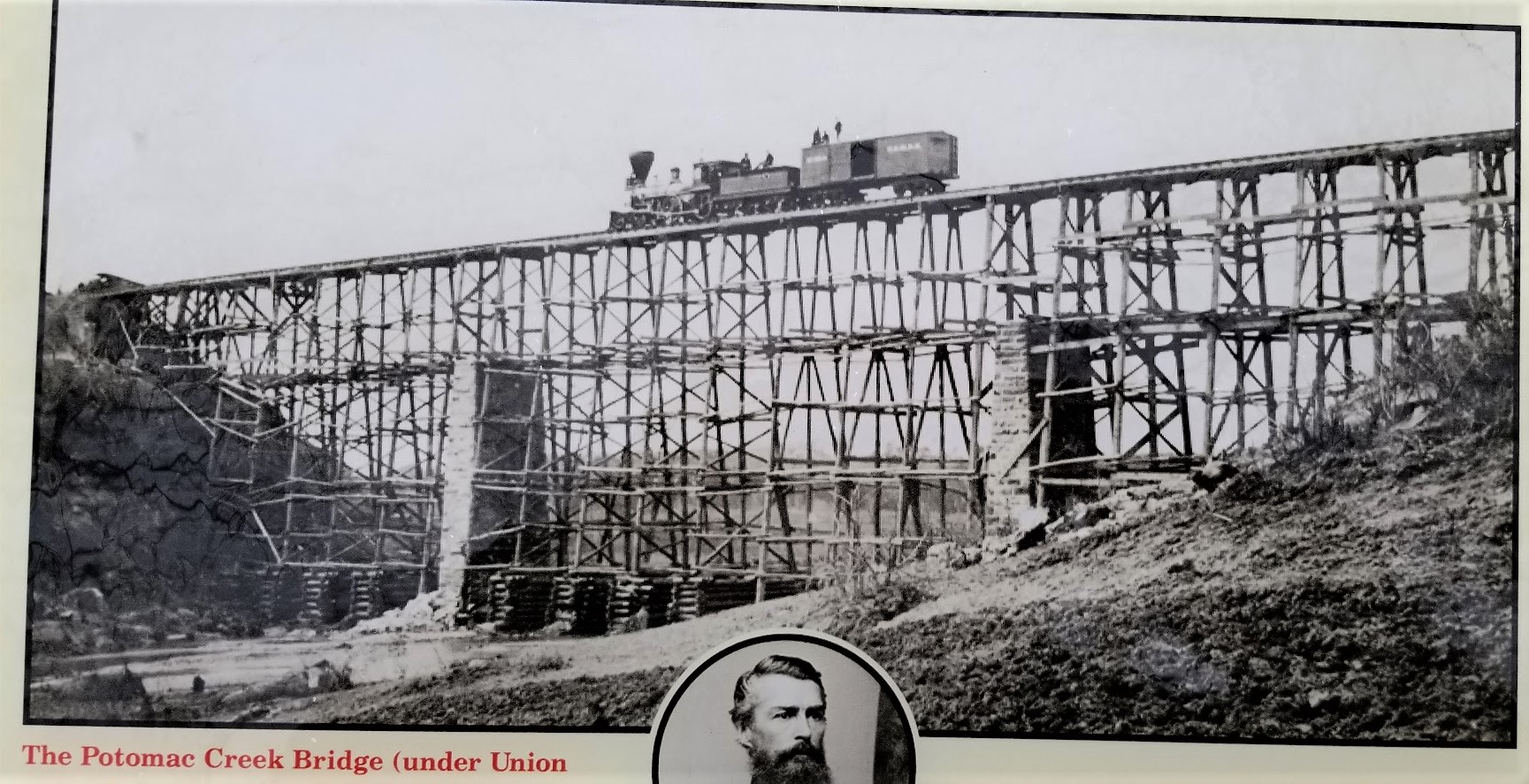
Our next geocache and county was up the road into Stafford County. It was a old virtual geocache at a piece of Civil War history (GCB1C). This huge stone block base is all that remains of a train bridge which spanned the Potomac Creek. The Richmond, Fredericksburg, and Potomac Railroad crossing this bridge was a major supply route for Confederate troops along the river. Early 1862, the troops were ordered to abandoned their positions here. The advancing Union troops found the bridge destroyed in an effort to slow them down. In May 1862, engineer Herman Haupt supervised the unskilled Union army soldiers in harvesting two million feet of lumber and reconstructing the bridge in just nine days (see photo at top of page). Over the next three years and continued destruction by the Confederates, the bridge was rebuilt four times using this same foundation. You can see the modern roadway through the trees on the right side.


Our next "county" geocache, one of Virginia's separate townships, was in Falls Church. Just a quick parking lot LPC (light post cache) (GC3XCZE), but it fills in a blank on the county map and keeps us moving forward.

Our next two geocaches are practically in the same spot at the intersecting corners of Arlington County, Fairfax County and Falls Church. Located in a small park in a residential neighborhood is the original 1791 survey stone marking the proposed western corner of the diamond shaped District of Columbia for the newly formed United States Capital. Maryland was donating land NE of the Potomac River, while Virginia was to donate land SW of the river forming the diamond shape. However, Virginia rescinded and we have the current half-diamond configuration of Washington D.C. today. The two geocaches located here are a virtual for the survey marker (GC6781) and a Challenge for finding 300 Virtual caches (GC572WE).


Just a short distance away, and in Fairfax County, is another Virtual geocache at this 9-11 Memorial (GCA072). There are a LOT of virtual caches in and around Washington DC, but we don't have the time at this point to get to them all. So we just try and grab a couple every time we pass through the area.


In an effort to not get too bogged down and spend the entire day in Virginia, I make another quick park & grab parking lot LPC find in Loudoun County (GC3V6QF).

We add Clarke County to our map by picking up a geocache in the County Seat of Berryville (GCXGQF). From the historical marker: "The year after Clarke County was formed in 1836, construction began on a brick courthouse based on county justice David Meade's design. The courthouse was remodeled in the Neoclassical style about 1850 when the portico and copula were added. Portraits of locally prominent judges and lawyers from the 1840's to the present are displayed in the courtroom. The last public hanging in Clarke County occurred here in 1905."


There was much to see around the courthouse square. One of which is this statue erected as a memorial to those Clarke County residents who fought and died during the Civil War defending states rights and the Confederacy.


The other was the Grace Episcopal Church and Graveyard erected in 1832. Do you know what the difference between a cemetery and a graveyard? Originally graveyards were burial grounds on church property, whereas cemeteries were land specifically designated for burials. Some very old churches actually have clergy or other very prominent members buried WITHIN the church under the floor. Their flat headstones would be down the isles between the pews.


My next two geocaches are in the Winchester Township. On previous roadtrips through Virginia I had just skipped the small townships, instead just focusing on the larger and rural counties. But I'm gonna have to fill these in on the map sooner or later. Might as well get to working on them.

During the Civil War, the Union and Confederate armies each used the Frederick County Courthouse (GC4XT0K) as a hospital and a prison. The Greek revival style courthouse was completed in 1840. It was the third courthouse constructed on this location. In 1758, the first courthouse was the site of George Washington's first election to office, when voters here elected him a member of the Virginia House of Burgesses.


Though these buildings have not been around that long, Colonel James Wood, a native of Winchester, England, laid out and founded the new Winchester in Virginia prior to 1743. It received a charter of incorporation from the colonial legislature in February 1752. Colonel Wood was the first surveyor of Orange County from which the county of Frederick was carved by an act of the House of Burgesses passed in 1738.


The Taylor Hotel, also our next virtual geocache (GC890KN), was a major stopping point for travelers because of its location on the Valley Turnpike and also was the center of town life. During the Civil War it was the headquarters for several commanders, most notably Confederate General Thomas J. "Stonewall" Jackson. This is the Taylor Hotel below as it looks today.


Arriving in November 1861, his stay at the hotel was short. Continuing crowds of people eager to meet the famous Stonewall Jackson, he moved a few days later to a private residence of the Lewis T. Moore house, which is now the Stonewall Jackson Headquarters Museum (GC4XT6Y) pictured below. He used this as his headquarters until March 1862 when he left Winchester to begin his Valley Campaign.


Finally exiting Virginia and making our way into West Virginia, our next stop was in the town of Middleway to grab a geocache for Jefferson County (GCM0TN). From the historical marker: Middleway, founded in the late 1700's, flourished as a trading center for most of the 1800's. About 1820, the Lutherans and German Reformed congregations joined together to build this church. Some years elapsed and the building was erected and finally the Presbyterians agreed to bear one third of the cost. Services were alternated, thus the name Union Church.


As the village declined, the Union Church and its cemetery deteriorated. In a more recent act of destruction, vandals smashed tombstones with bats and knocked others askew. The nearby Grace Episcopal Church, built in 1851, (pictured below), having acquired the forsaken property, stepped in and has restored the site to its former dignity.


For Berkeley County, I stop for one of the famous WVTim gadget caches. Since 2012, it has had over 1400 finders and awarded nearly 700 favorite points. Located on the grounds of a fire station, it's made to look like an old fire house. I'm not gonna give you the GC code to this one cause I'm gonna tell you how it works. In order to open the compartment that contains the log sheet, you must first open the compartment which contains a package of balloons. Insert the balloon into tube on the side leaving enough around the tube for you to blow on and inflate the balloon. As the balloon expands on the inside, it opens the door containing the swag and log sheet. A fairly simple gadget cache but fun none the less. Oh and please take your balloon with you as you don't want another cacher to using the same one as you.


Up next in Morgan County, I stopped for a quick guard rail cache (GC4AX47) but still a significant point of history. From this point along the banks of the Upper Potomac River, Stonewall Jackson began shelling Hancock, Maryland from Orrick's Hill, January 5, 1862 after it refused to surrender Jackson's men were able to plunder a large cache of rifles, ammo, and blankets from a supply train that came into Alpine Station. After destroying remaining supplies, the B&O Railway track and the bridge over the Great Cacapon, Jackson marched his army of 8,500 men to Romney and captured it.

Crossing the bridge over into Maryland, we followed the river westbound until we got to that narrow piece of Maryland that separates West Virginia from Pennsylvania. Turning north a few hundred feet into Pennsylvania for our next geocache in PA's Fulton County and a significant piece of survey history. Here is located a stone survey marker for the Mason-Dixon Line (GC2BCKX).


The Mason–Dixon Line was surveyed between 1763 and 1767 by Charles Mason and Jeremiah Dixon in the resolution of a border dispute between British colonies in Colonial America. The disputants engaged an expert British team, astronomer Charles Mason and surveyor Jeremiah Dixon, to survey what became known as the Mason–Dixon Line. It cost the Calverts of Maryland and the Penns of Pennsylvania £3,512/9 to have 244 miles surveyed with such accuracy. To them the money was well spent, for in a new country there was no other way of establishing ownership.

Mason and Dixon's actual survey line began to the south of Philadelphia, Pennsylvania, and extended from a benchmark east to the Delaware River and west to what was then the boundary with western Virginia. The surveyors also fixed the boundary between Delaware and Pennsylvania and the approximately north–south portion of the boundary between Delaware and Maryland. Most of the Delaware–Pennsylvania boundary is an arc, and the Delaware–Maryland boundary does not run truly north-south because it was intended to bisect the Delmarva Peninsula rather than follow a meridian.

And finally our last geocache of the day was a virtual (GCED74) at the Sideling Hill Welcome Center on I-68. The Interstate 68 highway through Maryland is also known as the National Freeway. It runs parallel to US-40 and the original National Road which was built in the 1800's. I'll talk more about the National Road more next week when we visit some of the remnants along the way including the first toll booth in the United States.

That's it for today. To follow along on our travels and keep up with my latest blogs, you may do so here of course by clicking the "Follow" button to the right. But also by using one or more of your favorite of these social media platforms: FacebookMeWeGabRedditParlorTwitterRVillageGETTRInstagram, and TruthSocial. These all link directly to my profiles. Again, please feel free to comment and / or share.

Friday, September 23, 2022

2021-03-23: Turning a 1400 Mile Drive into a 3404 Mile Road Trip! Day 1 in North Carolina and Virginia

WOW! What a roadtrip! So after two weeks, we finished up in Maiden, NC and now have to drive back to McCamey, TX to start the next project. Google maps says that it should only take 21 hours and 1400 miles. But where's the fun in that? BORING!! This wouldn't be the AwayWeGo Geocaching Adventures blog if we did that. NOPE, we took the LONG way back to Texas. It ended up taking us 12 days and 3404 miles later to reach our destination! So I hope you'll join us over these next few weeks as I bring you the stories and photos of the places we've discovered geocaching and sightseeing along the rural backroads and byways of the upper mid-west. So let's get started with Day 1 in North Carolina and Virginia...


Our first stop after checking out of the Lake Norman RV Resort on this cool spring morning, was for a virtual geocache (GC7B67D) in the historic town of Hillsborough, NC. On the grounds of the 1768 St. Mathews Church, later to become the Presbyterian Church, is the Old Town Cemetery. Not a traditional churchyard burial ground, it is one of North Carolina's oldest municipal cemeteries, established in 1757 by the Colonial Assembly and is the final resting place of several people who are significant to North Carolina history.


Among those buried here are William Hooper (1742-1790), who studied law in his native Massachusetts before moving to North Carolina where he established a law firm first in Wilmington and then Hillsborough. His gravestone lists several of his accomplishments, his greatest one was the signing of the Declaration of Independence. In 1894, Hooper's gravestone, and perhaps some of his remains, were moved to the Guilford Court House Revolutionary War battlefield. After a statue of Hooper was erected a few years later, the gravestone was returned to Hillsborough.

The tallest headstone is an obelisk honoring William Alexander Graham (1804-1875), who was governor, a United States Senator, and vice-presidential candidate.


The oldest part of the cemetery is just north of the church buildings in what now appears to be an empty field. In 2016, a ground-penetrating radar revealed that at least 100 graves are located there. The original grave markers, probably rough fieldstones or carved and painted wood have long vanished.

The only other stop in North Carolina on this trip was to make up for a previous DNF, see previous blog. Located in Chapel Hill was a geocache for the North Carolina County Challenge. I first attempted the geocache back in 2019 while working on another project and taking a roadtrip to pickup new counties. At that time of my visit the cache was missing so I wasn't able to sign the logsheet. Last year I completed the last couple of missing counties I needed to complete the state, but wasn't able to make it back to avenge my DNF. Upon this return trip, I noticed a new earthcache was placed at the outdoor amphitheater. So we gathered the needed answers to submit for the find.


Then we made the short hike through the park into the woods to find the ammo can replacement to claim a find for finding a cache in ALL 100 North Carolina Counties (GC19YRC)!


Crossing over into Virginia, it's back to focusing on county caching, virtuals, and other places of interest. First up were a pair of geocaches in Brunswick County and the town of Alberta. Usually not something I want to do when I don't want to spend a lot of time and that is hunt for a train hide geocache (GC80MYC). However this one was found pretty quickly and I moved a few blocks down the road.


We drove to another cache (GC8WD4N) just down the road at the sight of the original school house. I was hoping to find the remains of the school or something. But it was demolished in the 1980's and nothing remains except the short entry road to an empty field. I did find the geocache though.

Every now and then you get the unexpected surprise of finding something interesting when geocaching and sightseeing along the backroads during a road trip. The old bank building, now abandoned, is still standing on Main Street and 1st. I did a quick search to try and find some history on the building but didn't have any luck. It looks like a similar building I saw down in a small town along the Rio Grande in South Texas.


Driving north on US-1 into Dinwiddie County, we passed by this old motel and I just had to stop and get a photo of it. Located in McKenney, VA, the Wilmurt's Motel first opened in the 1930's as Wilmurt's Lunch Room, Cabins, and an Esso Gas station. As automobile travel grew in popularity after WWII, it expanded into a motor court / motel style business and did away with the cabins. It finally closed in the early 2000's and sits empty.


For this counties cache, we drove up to the town of Dewitt at the old fire tower (GC84NWP). The fire tower is no longer in service but at one time there were more than 150 fire towers scattered all across Virginia and were used to detect forest fires. Tower operators would sit up in the small room at the top mostly during the spring and look for smoke columns. When they saw one they would check with a neighboring tower for a cross reference and then call or radio a forestry person who would respond. Virginia on average has about 1,000 wildfires each year.


When we got to the city of Richmond, we had originally intended to find the virtual geocache at one of the large cemeteries that contain some significant interments of Virginia history. However by the time we got there they were just closing the gates so we couldn't get in.

So we drove over to the Virginia War Memorial for the virtual geocache there (GC7B656). In 1950, five years after the end of World War II, the Virginia General Assembly authorized the building of a memorial to honor and remember the nearly 10,000 Virginians who made the ultimate sacrifice serving in the U.S Armed Forces. A design was chosen, as was the location – nearly five acres overlooking the James River and downtown Richmond along U.S. Routes 1 and 301, the primary route from Maine to Florida before the construction of Interstate 95. As construction began, America entered the Korean War and plans were changed to include the heroes of this conflict. Construction was completed in 1955 and the Memorial was officially dedicated on February 29, 1956. The Memorial celebrated its 60th anniversary in 2016. The photo of the statue at the top of this page is looking through the center of this building below.


Our final geocaching stop for the day was in Hanover County at the I-95 Travel Bug Hotel (GC8132F). By now it was around 7:30 PM and we were hungry and tired ourselves and still needed to figure out where we were gonna stay for the night. So stop by next week when I'll show you Day 2 traveling through Virginia, Maryland, and West Virginia's colonial history, Revolutionary and Civil War sites and more.

To follow along on our travels and keep up with my latest blogs, you may do so here of course by clicking the "Follow" button to the right. But also by using one or more of your favorite of these social media platforms: FacebookMeWeGabRedditParlorTwitterRVillageGETTRInstagram, and TruthSocial. These all link directly to my profiles. Again, please feel free to comment and / or share.

Friday, September 16, 2022

2021-03-05: Touring the Mississippi Gulf Coast for History and Lighthouses

Finishing up the eastbound segment of our huge looping roadtrip around the east half of the United States, we followed the Mississippi Gulf Coast to check out some lighthouses and other historical sites. Obviously picking up some geocaches along the way too. So join us as we exit the Interstate, drop down to the backroads highway of US-90, and let's see what (and who) we found...

Our first geocaching stop was for a virtual geocache (GCED4C) at the statue of French explorer Jean Baptiste Le Moyne. Born in Montreal, New France (now Canada) in 1680, he landed and explored this area of Bay St Louis, MS in 1699. He was appointed governor of French Louisiana several times  in the early 1700's. Also known as Sieur de Bienville, he died while in Paris, France in 1767.


Moving along to Gulfport, MS, we come to our first lighthouse. Ship Island is located out in the Gulf of Mexico, about 12 miles south of Gulfport. The island got its name because it was often used by early explorers and larger ships to anchor, sending smaller boats navigating the shallower waters to the mainland. With the efforts of Congressman, and later as Senator, Jefferson Davis in the 1840's, Ship Island finally got its first lighthouse built in 1853. It was a 45-foot round tower made of brick.

In 1861, Confederate soldiers abandoned the fort and lighthouse on the island and returned to the mainland. They set the structures on fire to make it more difficult for Union troops to use the lighthouse to aid in navigating the waters. However, Union forces occupied the island before long and had the lighthouse operational once again by late 1862. In 1886, the brick lighthouse was considered unsafe and a square wooden lighthouse was constructed later that year. The lighthouse continued operating by the U.S. Coast Guard until 1957.

In 1959, a private use permit was granted to Philip Duvic who renovated the bottom floor to a kitchen and bathroom, second floor into women's quarters, third floor into a men's dorm, and the top floor a honeymoon suite. He eventually purchased the lighthouse in 1965 when the Coast Guard put lighthouses up for sale.

In 1969, Hurricane Camille severely damaged the wooden structure. And in June 1972, two campers lit a campfire too close for the windy conditions and caught the lighthouse on fire, completely destroying it. In 1999, a replica lighthouse was built on the island but destroyed in 2005 by Hurricane Katrina. And finally, another replica (pictured) was built in 2011, but not on Ship Island. This time right on US-90 in Gulfport making it more accessible to tourists.


I also grabbed the geocache near the lighthouse (GC6ZKCN) before driving off to the next location.

Further east down the beach and a block off of US-90, you'll find this red-brick building and our next virtual geocache (GCD69F). The Mississippi City Courthouse building was originally constructed in 1893 as part of the Harrison County Clerks office, the "Old Courthouse." It was the last remaining structure associated with a complex of courthouse buildings in Mississippi City, which served as the county seat from 1841 until 1902. After that the county seat was moved to Gulfport. The original building was destroyed during Hurricane Katrina in 2005. This replica you now see was constructed in 2009.


Moving on over to Biloxi, we come to one of the lessor known lighthouses on the Gulf Coast. Constructed in 1965 as part of the Broadwater Beach Resort, the resort was destroyed by Hurricane Camille in 1969. Rebuilt as the President Casino in 1992, it too was destroyed in 2005 by Hurricane Katrina. This is all that remains. Even the geocache hidden near the base tends to disappear often and I had to DNF that one (GC6DTPB).


The Biloxi Lighthouse (GC7B8V6) was one of three Mississippi Sound lighthouses authorized in 1847 by legislation sponsored by Mississippi Representative Jefferson Davis. The Biloxi Lighthouse was erected in 1848 and was one of the first cast-iron lighthouses in the South. It has survived two of the deadliest hurricanes in Gulf Coast history, Camille in 1969 and Katrina in 2005. Katrina’s record-breaking storm surge crested at 27.8 feet above mean sea level. It destroyed nearly the entire city, but the lighthouse remained standing.


One of the features of this lighthouse is that it contains a webcam. You can login to the live feed from your smartphone to take that unique selfie as if you were both on the ground and up inside the lighthouse. Yep, that's me down in the lower left corner by the light post.


Our final stop was in Ocean Springs, MS for another virtual geocache (GCEC3D) at the Mississippi Vietnam Veteran's Memorial.


Making our way back to Interstate 10, yeah I know it sounds boring, but we have to get to Central Florida. We spent the following day with family and the next morning saying my last goodbye at my father's funeral. After the funeral we had to get back on the road up to North Carolina where we return to the Maiden Creek solar project for a couple weeks of touch up work. Then we head back to Texas for the next project. But we'll be taking the LOOOONG WAY back via the northern route! So be sure to check back in soon. Until next time...


To follow along on our travels and keep up with my latest blogs, you may do so here of course by clicking the "Follow" button to the right. But also by using one or more of your favorite of these social media platforms: FacebookMeWeGabRedditParlorTwitterRVillageGETTRInstagram, and TruthSocial. These all link directly to my profiles. Again, please feel free to comment and / or share.

Saturday, August 27, 2022

2021-03-04: Visiting the Less Touristy Sites in New Orleans

Hey Everyone! Welcome back to Day #2 of our 4,000+ mile roadtrip. Today we start off in New Orleans, Louisiana. Not the Mardi Gras, the bars, restaurants, and nightlife party, but the historical, less visited, peaceful attractions. So hop onboard and join us for a geocaching adventure...


We started the day with breakfast, a cache, and a new county at a Waffle House just down the street. We ordered a couple of breakfast bowls to-go. While they were cooking, I grabbed the geocache (GC8MND3) in the parking lot to fill in the blank for St. Charles Parish.

My next county cache was in Jefferson Parish. At the Veterans Memorial Century of Sentries Park, there was a multi-cache hidden here which I could not find the final stage (GC110R8). But it was still a worthy stop. There were many military display's such as the Douglas A-4 Skyhawk Vietnam War attack plane, a 1941 Plymouth Sedan Army staff car, a Vietnam River Patrol boat, a couple of cannons and a torpedo.


Now since I couldn't find that last geocache for the county, I settled on a quick parking lot LPC hide (GC77DYE).

In Orleans Parish, our next stop was the site of the Spanish Fort at Bayou St. John (GC8GC4J). The first small fort here was erected by the French in 1701, before the founding of the city of New Orleans, to protect the important trade route along Bayou St. John. After Louisiana passed to Spanish control, a larger brick fort was constructed at the site of the neglected old French fortification; this was known as San Juan del Bayou. Louisiana passed back to France and then to the hands of the United States. The fort was decommissioned in 1823.


This is the story of the grave at Spanish Fort. During the Spanish days, the Commandant of Fort St. John was Sancho Pablo. He had opened negotiations with the chief of a local Choctaw tribe, Waw-he-wawa (White Goose), who lived down the bayou with his daughter Owaissee (Bluebird). Sometimes Pablo visited the Indian camp and became acquainted with Bluebird as well.

One day, as the legend goes, Bluebird took her canoe down Bayou St. John to the lake. The choppy waters began to pound her canoe until it nearly capsized. Seeing this from the fort, Sancho Pablo ordered his men to prepare a boat at once to rescue her. When they reached her, Pablo personally lifted Bluebird into the Spanish boat to safety and escorted her home. Needless to say, Sancho Pablo and Bluebird fell in love with each other. Bluebird would paddle down the bayou again and again at night to meet with Sancho.

White Goose became suspicious, however, that his daughter was meeting with this Spaniard; and he became alarmed being strongly opposed to such a relationship. He secretly followed his daughter down the bayou one night and discovered that she was meeting with Pablo. White Goose therefore resolved to kill the Spaniard. On an ominously dark night, the Indian father traveled down the bayou in a canoe alone. As the canoe approached the fort in the pitch black night, Pablo believed the boat contained Bluebird coming to visit. Instead the Spaniard soon discovered it was Bluebird's father who came only for blood. White Goose killed Sancho Pablo on the spot.


Legend has it that Pablo's last words were of his eternal love for Bluebird. The soldiers in the fort soon were startled by the sounds of the struggle, but the Indian chief had disappeared. The Spanish soldiers buried the body of their leader on the grounds of the old Spanish Fort. Legend says that the Indian village relocated. Neither Bluebird nor White Goose was ever heard from again.
(https://allpoetry.com/poem/513738-Sancho-Pablo-And-Bluebird-by-Dreamweaver)

And then, not too far away, was the Milneburg Lighthouse (GC8GC4N). Originally called Port Pontchartrain Lighthouse until 1929. This now landlocked lighthouse was located at the end of Milneburg pier. The brick lighthouse was built in 1855 which replaced the original wooden one which was built in 1832. Milneburg was a small town on the lake shore that was absorbed by New Orleans. The area was connected to the city by Elysian Fields Avenue. In 1830 it was decided to build the region's first railway along the route. The Pontchartrain Rail-Road started steam locomotive which carried people and cargo along the 5 mile trip. The port boomed. Hotels, saloons, bath houses, and resorts were built around it. The importance of Milneburg in shipping declined in the late 19th century, but it remained an important resort. Between 1920s and 1930s new land was reclaimed by dreading the shallows of Lake Pontchartrain which brought the end of old Milneburg.


Unfortunately I didn't get the geocache that was there. It wasn't that I didn't find it, but I didn't get to look. From where I took this photo were two parking spots. We got out of the GeoJeep to walk over for a closer look and to find the cache. Almost immediately, up rolls a golf cart with a security guard telling us that we can't walk out to see the lighthouse because of covid. REALLY? If it were not for the security guard, I'd be able to look completely all around in every direction and NOT see a single person except for my wife and I. I'm pretty sure covid would NOT be an issue. Oh well, off to the next one.

We planned on visiting the most famous of the New Orleans cemeteries, Saint Lewis Cemetery Number 1. With famous permanent residents like voodoo priestess Marie Laveau (1801-1881), civil rights activist Homer Plessy (1862-1925) of the Plessy vs Ferguson Supreme Court case, and future resident and actor Nicholas Cage who already has a 9' tall pyramid placed for his tomb. But it was closed because of... you guessed it... covid.

So we went across the highway to the Metairie Cemetery where we found six of the more than a dozen geocaches hidden there. The Metairie Cemetery Association received its charter in May 1872. This large cemetery was built on a former racetrack, and the oval track shape is still there. Metairie was part of the Rural (Victorian) Cemetery Movement. It’s landscaped and features elements like lakes and wide roads connecting to footpaths. Interments of note include singer Louis Prima, 49 kings of Carnival, and numerous Louisiana state governors and NOLA mayors.

Just a couple of notable residents here: Thomas Milton Benson (1927-2018), who was the owner of the NFL's New Orleans Saints and the NBA's New Orleans Pelicans.


Josie Arlington was a New Orleans madam whose crypt was once believed to be haunted. It was rumored that the statue of the woman in front of the tomb would come to life and walk the cemetery grounds at night. It was later discovered that a street light reflecting off the tomb gave it a reddish glow, lending credence to the rumors of the haunting. Josie Arlington's body was later moved to an unknown location within the same cemetery.

Located in the center of the Metairie Cemetery is the Tomb of the Army of Northern Virginia. Dedicated on May 10, 1881, the monument was erected in memory to the men of the Division of the Army of Northern Virginia, who served and died in the Civil War. The monument, made of white granite, rises fifty feet above the ground with a statue of General Stonewall Jackson on top and the inscription: "ARMY OF NORTHERN VIRGINIA, LOUISIANA DIVISION," and "FROM MANASSAS TO APPOMATTOX, 1861 TO 1865." Located within the hill below this monument, is a large chamber containing the vaults of many Confederate Officers.

Jefferson Davis, President of the Confederate States, was the unrepentant highest ranking Confederate leader of the South. By the time his peaceful death occurred while visiting New Orleans, he was the symbol of the Lost Cause and the most revered man in the South. Eighteen months after his death and temporary burial in New Orleans Metairie Cemetery, Davis's widow, Varina, decided the final burial place was to be Richmond's Hollywood Cemetery, considered the National Cemetery of the Confederacy. 


His remains, were removed from the vault in New Orleans and placed on a flag-draped caisson escorted by honor guards composed of his old soldiers to Memorial Hall, where he lay in state. The next day, as thousands of people silently watched from the sidewalks and balconies, the caisson bore his body to a waiting funeral train. On the way, bonfires beside the tracks lit up ranks of Davis's old soldiers standing at attention beside stacked arms. In Richmond, Gray haired veterans escorted him to the Virginia statehouse where thousands filed past in respect before internment.

Jefferson Davis was the only Southern leader shackled in a dungeon and sacrificed as atonement for the sins of many. He refused to apply for a pardon because, he said, "I have not repented." In 1978, the United States Congress posthumously restored Davis's citizenship. 

Driving east into Saint Bernard Parish, we stop for my next county cache at Chalmette Battlefield and National Cemetery (GCA55A). Major General Andrew Jackson's troops were outnumbered and less experienced yet they defended and secured the port of New Orleans from British invasion on January 8, 1815. This victory at the Chalmette Plantation was the last major battle in the War of 1812. The American victory preserved U.S. claims to the Louisiana Purchase territory, prompted settlement in the Mississippi River Valley, made Jackson a national hero, and encouraged American pride and unity.

The construction of a monument honoring Andrew Jackson and his troops was the first step in recognizing the importance of the battlefield and saving it for future generations. In 1852 the Louisiana legislature appropriated funds to purchase land at the battlefield and build a monument there. The project was plagued with funding problems for decades and was finally completed in 1908. In 1939 Chalmette National Historical Park was created and the site became part of the National Park Service.


The destruction of their plantation during the Battle of New Orleans left the de Chalmet family in financial trouble. In 1817, brothers Hilaire and and Louis St. Amand bought the land. The St. Amands were prominent free people of color who already owned several plantations. In the early 1800's, it was not unusual for free people of color to own plantations and slaves in Louisiana. Actually according to the 1860 U.S. census, only 4% of southern whites owned slaves while 28% of freed blacks in New Orleans owned slaves.

The first owner of the Malus-Beauregard House was Madeleine Pannetier Malus, a widow who purchased land from the St. Amand brothers when they divided the land into small tracts in 1832. Malus built a French Colonial house in 1833 or 1834. After her death in 1835, Caroline Fabre Cantrelle bought the house and remolded it to the Greek Revival style it is currently. Its last private owner was Rene Beauregard, son of Confederate General P. T. Beauregard, who purchased it in 1880. The New Orleans Terminal Company then owned the property until 1949, when it became part of the Chalmette National Historical Park.


Looking at the house from the front or the back and you get the impression of an ominous grand estate. In reality, when you look at it from the side, the house is only one room deep with only four rooms on each floor.


The Chalmette National Cemetery was established in 1864 as a burial place for Union soldiers who died in the Gulf area during the Civil War. It also served as a site for reburials of soldiers from battlefield cemeteries in the region. This plot of land was part of the battlefield during the Battle of New Orleans. Only four U.S. veterans of the War of 1812 are buried here. None of the British who died in the battle are buried in the cemetery.


Also located on four acres of the battlefield, is the Freedmen's Cemetery. It was established by the Freedmen's Bureau in 1867, when the bureau received permission to use a portion of the battlefield as a civilian burial ground. The property reverted to other ownership when the bureau was discontinued, and the cemetery gradually fell into ruins. All above ground traces disappeared before the start of the 1900's.

The National Park Service received stewardship of the cemeteries in 1933. There are over 15,000 individuals buried in the 17.5 acre cemetery. Veterans of all major American wars and conflicts are interred here. Of these 15,000, more than 6,700 are unknown. By 1945 all available burial sites were either taken or reserved and the cemetery was closed. It was re-opened briefly in the 1960's for burial of Vietnam Veterans.

There are two burials I wanted to bring to your attention. One is the oldest and belongs to Pvt Elkanah Anderson (1774-1815). Marched from Hickman County Tennessee, then fought and died at the Battle of New Orleans. Mortally wounded in battle on January 8, 1815, then died on January 14, 1815.

The other was Sarah Rosetta Wakeman (1843-1864). Civil War Union Soldier. The oldest child in a poor, large farming family in upstate New York, she left home at nineteen years of age and found she could make more money by dressing as a man and working as a coal handler on a canal boat. Upon learning she could make thirteen dollars a month as a soldier, she disguised herself as a man and enlisted on 30 August 1862 in Montgomery County, New York, as "Lyons Wakeman" in the 153rd New York Volunteer Infantry, Company G which shortly thereafter would be redesignated as Company H. She served until she died of dysentery after fighting in the Battle of Pleasant Hill in Louisiana. Details of her experiences are found in her letters compiled in a book entitled "An Uncommon Soldier" edited by Lauren Cook Burgess. Her total service in the U S Army covered more than one year and seven months.


And finally, our last stop in New Orleans was out of this world (GCB50B). This is the Michoud Assembly Facility for NASA where much of the United States Space Program began. The Saturn 5 booster stage that launched all of the moon missions as well as all of the External Tank for the Space Shuttles were built here. Currently portions of the Orion Capsule slated to take the first men to Mars is being built here.

There used to be two metal sculptures near this virtual geocache location. One is honoring STS 107 which was the Columbia Mission that was lost upon reentry over Texas. The other is dedicated to the Challenger Crew who made the ultimate sacrifice when the shuttle exploded shortly after launching off the coast of Florida.


So that was our tour of New Orleans. Probably NOT the typical sites that most visitors to the "Big Easy" see. Maybe next time when we have longer to stay we'll check out the downtown restaurants and go on a ghost tour or something normal like most tourists. See you next time.

To follow along on our travels and keep up with my latest blogs, you may do so here of course by clicking the "Follow" button to the right. But also by using one or more of your favorite of these social media platforms: FacebookMeWeGabRedditParlorTwitterRVillageGETTRInstagram, and TruthSocial. These all link directly to my profiles. Again, please feel free to comment and / or share.

Saturday, July 23, 2022

2021-03-03: Roadtrip! Our First Day of a 4000+ Mile Road Trip from Texas to Louisiana

WOHOO!! Time for another road trip!! After four months in southeast Texas, we laid the groundwork on this project and turned it over to the remaining crews. So where's the next big project? Well the next big project is just across the state back in West Texas. 

But first, I gotta make a quick overnight stop in Florida for my father's funeral. Then we head back up to Maiden Creek, North Carolina for two weeks worth of work putting the finishing touches on a project we started last year. And for an adventure we're gonna take the long way back to Texas. I mean what's the excitement of just driving the quickest interstate highway to your destination right? So a 500 mile roadtrip turns into a 4,000 mile roadtrip!


Day #1 of this road trip and my first goal is just getting out of Texas to get a jump on putting miles in the rear view mirrors. Our first stop was at a virtual geocache and an earthcache (GCCF25, GC7VW68) in Dequincy, Louisiana.

In 1897, the Kansas City Southern (KCS) Railroad laid track through the town of DeQuincy and the first depot was built on this site. In the early 1920's KCS began rebuilding or remodeling many of its stations along the line in Western Louisiana. This building was completely rebuild in 1923 and eventually turned into a museum in the 1970's.


Located trackside of the DeQuincy Railroad Museum is a 1913 Steam Locomotive and a 1947 Pullman passenger car. While we were checking out the outdoor displays, a modern day Kansas City Southern freight train whistled past.


Our first new geocaching county to check off the list was up next for Allen Parish. We stopped in the town of Oakdale and the Calcasieu River Dam (GC81VQW). After taking a few photos I began looking unsuccessfully for the geocache. Previous finders said that it was buried, something they're not supposed to be. It has since been archived.


Still needing a geocache for the county, or Parish as they are called in Louisiana, I made a stop for a quick roadside cache (GC8XN4V) as we continued eastbound.

The next county on the list was Evangeline Parish. Near the town of Bayou Chicot is the Vandenburg Cemetery and my next geocache (GCW780). A well maintained cemetery with over 800 interments here, the oldest dating back to 1818. It's too bad that I don't have more time to look around here.

Did you know there is a difference between a cemetery and a graveyard? I mean everybody, including myself, usually just calls them cemeteries. But traditionally a graveyard is a cemetery that's attached to a church. Just like my next geocache...

The White's Chapel United Methodist Church (GC3730Q) was built in 1894 by Hugh and Lee Evans on land donated by Wilson A. O'Quin Sr. It was named in honor of Rev. Frederick White who organized it in 1870. There are less than 300 interments buried here with the oldest dating back to 1877, a SGT Leon Joseph Campbell.


While it was great to visit an old historic church and graveyard, I wasn't able to find the geocache. And not wanting to get too far behind in miles, I skip the next few geocaches and drive quickly beyond Baton Rouge. Though that also meant skipping a few needed counties too. That just a reason for another road trip!

When normally passing through down I-10 east-west, most people take the I-12 shortcut between Baton Rouge and Slidell. Since I still wanted to get those lower counties, I went south into Ascension Parish and the town of Prairieville. The Prairieville Cemetery (GC35J5A) is scattered with old growth oak trees which makes for a beautiful setting and a little spooky too. The cemetery has over 3000 interments dating back to 1812.


Moving right along, the next geocache is just a quick roadside park and grab at an I-10 exit for a find in St. James Parish (GC50YRT). While here we ran into another geocacher named SWAseekers, who was also on a county caching run in Southern Louisiana.

Next in St. John the Baptist Parish, I met up with SWAseekers once again for a quick parking lot geocache (GC8BC9X).

Since we didn't want to get into New Orleans during the busy evening hours, we decided to call it a day. Plus it was already after 5:00 PM and we were hungry and tired. Tomorrow morning we'll visit New Orleans while it is less crowded. Thanks for riding along and we'll see you again soon!

To follow along on our travels and keep up with my latest blogs, you may do so here of course by clicking the "Follow" button to the right. But also by using one or more of your favorite of these social media platforms: FacebookMeWeGabRedditParlorTwitterRVillageGETTRInstagram, and TruthSocial. These all link directly to my profiles. Again, please feel free to comment and / or share.