Showing posts with label Oklahoma. Show all posts

Sunday, January 17, 2021

2019-04-21: A Roadtrip from Oklahoma to Texas and Visiting a Petrified Villa, an 1800's Church, and the Historic Chisholm Trail

So after spending the day yesterday in Oklahoma at the Wichita Mountains Wildlife Refuge, today is the roadtrip back to Killeen, Texas. And of course we can't take a drive that far without any geocaching stops. Anybody want to go for a ride with us? There's always room for virtual passengers. Let's fuel up and hit the road.


After checking out of the hotel this morning, I walked across the street to the grassy area by the I-44 onramp. A quick geocache in a tree so close that I just can't leave without finding (GC2W45H).

There were some other geocaches around Lawton with some high favorite points and we wanted to check those out also. This one was a very creative container (GC47ZEA). The geocacher took some time creating this one. You could almost call it "Me and Mini-Me"! Oh, and the name of the road that this coffee shop is located...: Cache Road! Definitely gets another favorite point from us too. It's too bad that the coffee shop itself wasn't open this early on a Sunday Easter morning because we hadn't found our morning coffee yet.


Another high favorite geocache was a virtual cache at the Great Plains Museum (GC81E5). We like museums. But of course not open at this time. So a quick photo by the "long-horn bison"?


Our last geocache (GC5FDZ7) in Lawton, Oklahoma was at the Elmer Thomas Park. It a large park behind the Great Plains Museum. It was called "Circle the Wagons" and it was at an old covered wagon display. A tricky cache to find because the camo blends in really well. One out of three cachers end up logging a DNF. However, I was fortunate enough to find this one. Though I was so intent on finding this one I forgot to take a photo of the wagon.

Driving over to Duncan, Oklahoma for our next virtual geocache (GC1C59) at the Chisholm Trail Heritage Center. The Chisholm Trail was a trail used in the post-Civil War era to drive cattle overland from ranches in Texas to Kansas railheads. The trail was established by Black Beaver, a Delaware Indian scout and his friend Jesse Chisholm, a merchant and part Cherokee. The trail was used from 1867 through 1884. The herds on the trail rides usually numbered around 2500 to 3000 head of cattle each, but have been as many as 10,000 in a single herd. The herds were usually spaced about 10 miles apart for the long journey, which was about a day apart. At this geocache location is a large bronze statue representing such a cattle drive.


Also in the town of Duncan is one that I just couldn't pass up on. Because I work as a construction surveyor, it was a given that I go find a geocache called "The Survey Base Line" (GC6DZZG). "The distinctive checkerboard pattern of land boundaries in Oklahoma and all across the West was conceived by Thomas Jefferson in the early 1780's, long before the rough and rugged character of this vast wilderness had been charted. Jefferson was the grand architect of the distinct western landscape. In the late 1800’s government surveyors were commissioned to survey the public lands for sale or grant to the public."

This cache is located at a historical geographic monument for the Indian Base Line in Oklahoma. The "Initial Point was established by the U.S. Government in 1870. All Oklahoma except the panhandle was then divided into townships North and South and Ranges East and West of the Initial Point. The Indian Base Line is two-tenths of a mile south of this point on Beech Road. Duncan is 41 miles west of the Initial Point. The stones in this monument were taken from the Initial Point."


Our last stop in Addington, Oklahoma is another geocache and historical monument marking the Chisholm Trail Lookout Point (GC5W7H5). The two hills here represented landmarks used by Cattle Drivers on the Chisholm Trail. As they came out of the Red River valley they could see these two hills and used them to drive the cattle north to this location. Originally known as Lookout Point, they became known as Monument Hills. The Chisholm Trail and millions of Longhorns, went just to the east of this hill marked by this monument.


Driving along US-81 now down into Texas, we made a quick roadside picnic area stop to grab two geocaches (GC10MJD, GC431J6).

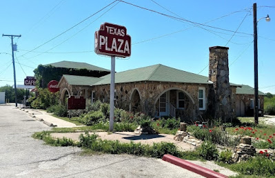
Arriving in Decatur, Texas, we made a "must-do" geocaching stop for a roadside attraction Americana history. "Petrified" (GC3X4ZF) is located at the Texas Tourist Camp Complex. From the historical marker: Local businessman E.F. Boydston (1888-1945) purchased this site, a former seed lot, in 1927 for $400. Recognizing a potential business opportunity in offering services to the traveling public, he built a wooden shed and gas station in 1927. Travelers were allowed to build campfires during overnight stays, and by 1931 Boydston added three wooden cabins with garages to the camp complex. The buildings were later faced with rock, and more cabins and garages were added in 1935. The original wooden gas station (photo at top of page) was covered with petrified wood in 1935 when the highway was widened and remained in operation by the Boydston family until 1988.


The Texas Lunchroom, a one room frame building, was built in 1929. Renamed The Texas Cafe in 1935 and refaced with stone to match the other buildings in the complex, it was enlarged to provide second floor living quarters. Popular with local high school and college students, as well as families and the traveling public, it was closed in the 1960's after a highway bypass built west of town diverted traffic from this area. The cafe re-opened in 1993. One of the few intact examples of tourist camps built throughout Texas in the mid-20th century. This property is significant for its association with the early development of automobile tourism.


Our last stop, also in Decatur, was for the geocache "Goin' to the Chapel" (GC198AR). The Episcopal Church of the Resurrection is the oldest original church building in Decatur. Consecrated by great missionary Bishop, the Rt. Rev. A.C. Garrett. Erected facing Main Street (2 blocks west of square) in 1889. Known as "the little church with the crosses", by 1912 it had deteriorated, but it was restored and moved facing Walnut Street.

In 1940 the building was sold and used as a mattress factory. Then it was rescued the same year and moved to this location, with the sanctuary placed symbolically to the east towards Jerusalem.


So that's it for today's roadtrip back home from Oklahoma to Texas. Thanks for riding along with us. Feel free to leave your comments and/or share our adventures with your friends. You can find us on most social media platforms:  FacebookMeWeParlerGabTwitterInstagramMAGAbook, and Reddit. Follow us on any or all of these platforms.

See you next time...

Saturday, January 9, 2021

2019-04-20: Geocaching, Hiking, and Exploring the Beautiful Wichita Mountains Wildlife Refuge in Oklahoma

For today's adventure, we are once again Away-WE-Go for this Easter holiday weekend. Most of these blog posts I'm usually by myself on my Sunday drive back to work. Having this long weekend off, we decided to take a drive up to Oklahoma.


If you recall last month on my long roadtrip back from Minnesota, I had stopped at the Wichita Mountains Wildlife Refuge. I mentioned that they perform a live Passion Play every Easter and have been doing it for nearly 80 years. You can read more about that by revisiting my blog page here. Candy and I thought it would be a great idea to go and see it. So we drove up yesterday.

The granite walls of the Wichita Mountains offered refuge to waves of people over many centuries, beginning with Nomadic Native Americans. In the late 1800's, conservationists made plans to re-establish bison and other imperiled species in the region. Looking for the best habitat, they decided that the sheltered prairie of the Wichita Mountains was the ideal location.

This morning we came here to see more of the natural refuge, do some hiking, and hopefully see some wildlife. For our first stop we drove over to French Lake and parked by the Bison Trail for a hike over to the dam. The many dams located in this refuge which form all the lakes were constructed in the 1930's as park of the Federal Work Projects. We hiked the Elk Trail back to the GeoJeep. It was a pleasant, clear, perfect weather morning. Got some nice views of the lake and the dam. The only wildlife we saw was a bunch of turtles and some fish in the lake.


From there we drove south on Indiahoma Road down to our first geocache. The "Heart Rock Earthcache" (GC3AQ2J) is a large outcrop of lava rock forced up from below the surface. Many, many years of erosion created this heart shaped rock on a pedestal that's about chest high when standing next to it. If it wasn't at such an angle, it'd make a great picnic table. While there is a pull-off parking area for the scenic views, there's no mention of this heart rock formation. Just another reason why I like geocaching to find the unique roadside attractions.


Just as we got back to the GeoJeep, we were just in time to see a parade of more than a dozen old tractors going by. Now I'm not really into tractors but seeing some antique machinery being driven down the road was pretty cool.


Back up on State Road 49 through the middle of the Refuge, we come upon Prairie Dog Town. A field of hundreds of prairie dogs running around and popping up and down from their underground city. I wish I had my Nikon camera with me but I left it back in Texas. So I only have this fuzzy phone photo. Takes good pics normally, but not so good when you zoom in close.


Next we drive over to the southside of Quanah Parker Lake to the Little Baldy Trailhead. Crossing the Quanah Creek Dam which forms the lake, we begin hiking the Little Baldy Trail. Little Baldy is one of the rocky hills within the refuge. We hiked up to the top of for the views and for the Little Baldy virtual geocache (GC1E4D).


Returning to the GeoJeep and continuing down the road a few miles we finally saw some bison. So we pulled over, took some photos, and watched for a while.


It was now mid-afternoon and we didn't plan very well. We're now out of water and hungry because we didn't think about bringing snacks or food. We stopped by the Holy City of the Wichitas for a quick look to see what of the situation. People were already gathering and picking out their spots to watch the Passion Play which was still 10 hours away from starting. Candy got a quick look around at the buildings. They had bottled water but nothing to eat. So we needed to go back into Lawton to eat and return later.

As we were driving out we stopped at this structure. Completed in 1927, Benjamin Ferguson and his family lived in this house until 1942. About a half mile to the east is the Ingram Homestead. They were both built out of the round granite core stones that cover the hillsides of the refuge, and both were acquired during the 1901 land lottery held at Fort Sill. They reflect the hard work, ingenuity, and craftmanship of earlier generations.

In 1942, the U.S. Army used the right of eminent domain to acquire the homesteads to expand the artillery range of the adjacent Fort Sill. Fifteen years later the planned expansion was scrapped and the homesteads became a part of the Refuge. In 1981 they were added to the National Register of Historic Places.


After grabbing some dinner and now back at the hotel to freshen up after all the hiking today, we were too exhausted to drive back to the Refuge to sit and wait for the play to start. But now that we have a better understanding of what it would be like, we're better prepared to come back again. Though next time we'll have folding chairs, a cooler with drinks, and plenty of food.

Still a great day of hiking and exploring the Wichita Mountains Wildlife Refuge. Come back tomorrow for the roadtrip home. I've got a few interesting places on the agenda for the roadtrip home. See you then...

Sunday, November 29, 2020

2019-03-10: A Packed Geocaching Roadtrip Returning from Minnesota to Texas Day 4: Oklahoma & Finally Home!

WOW, What a trip! This packed geocaching roadtrip from Texas to Minnesota began a week ago yesterday. Now I'm finally back home. But wait let me not jump ahead and leave out today.


CuteLittleFuzzyMonkey (CLFM) and I started out early this morning in Lawton, Oklahoma. After breakfast and coffee, we drove over to the Fort Sill visitors center. Fort Sill was originally staked out January 8, 1869 by Maj Gen Phillip Sheridan to stop Indian Tribes from raiding border towns in Texas and Kansas. The garrison was originally called Camp Wichita and was referred to by the Indians as "the Soldier House at Medicine Bluffs." Sheridan later changed the name to Fort Sill in honor of his West Point classmate Brig Gen Joshua Sill, who died in the Civil War.

Today it is a U.S. Army Base covering almost 94,000 acres. It serves as home of the United States Army Field Artillery School as well as the Marine Corps' site for Field Artillery MOS school, the United States Army Air Defense Artillery School, the 31st Air Defense Artillery Brigade, and the 75th Field Artillery Brigade. Fort Sill is also one of the four locations for Army Basic Combat Training. It has played a significant role in every major American conflict since 1869.

Because CLFM has a military I.D., it was a little easier for the both of us to enter the base, as long as he was driving. So we swapped seats and now I was the navigator. Our first goal was to find the grave of a famous warrior.

Geronimo (1829 - 1909) was a prominent leader and medicine man from the Bedonkohe band of the Apache Tribe. From 1850 through 1886, Geronimo fought against Mexican and United States military campaigns in Northern Mexico's Chihuahua and Sonora and in the United States' New Mexico and Arizona.

In 1886, he "surrendered" for his third and last time. This last time he didn't break out. He was first sent to San Antonio, TX as a POW. Then transferred to Fort Pickens in Florida, Mt Vernon Barracks in Alabama, and finally Fort Sill, Oklahoma in 1894. With the exception of becoming an "attraction" in Pawnee Bill's Wild West Show around the country, Geronimo spent the remainder of his life farming with his family on land surrounding Fort Sill. He died of pneumonia on February 17, 1909 after being through from his horse and laying out in the cold overnight.

He is buried there at Fort Sill among the rest of his family and other Apache POW's. His gravesite is the virtual geocache we came looking for (GC3B0D).


Also located within Fort Sill are our next two geocaches, a virtual (GCKPGE) and an earthcache (GC27G76). From the historical marker: "This Unique Landmark at the eastern end of the Wichita Mountains was noted, described, and explored by all early expeditions and was held in deep reverence by the Indian tribes of this area from time immemorial.

"The four contiguous porphyry bluffs form a picturesque a mile in length on the south side of Medicine Bluff Creek, a tributary of Cache Creek and Red River. It is evidently the result of an ancient cataclysm in which half of a rock dome was raised along a crack or fault.


"When Fort Sill was established in 1869, the Indians named it “The Soldier House at Medicine Bluffs.” The site is rich in legends and history. You are facing the north side of bluff no. 3, which consists of a sheer cliff 310 feet high, rising abruptly from the creek. A rock cairn erected by medicine men on its summit was still standing when Fort Sill was founded. Here the sick were brought to be healed or disposed of by the Great Spirit, young braves fasted in lonely vigils seeking visions of the supernatural, and warriors presented their shields to the rising sun for power. Legends say that this was also a famous place for Indian suicides. The huge fissure between bluffs no. 2 and 3 was known as the “Medicine Man’s Walk.”"


Leaving Fort Sill, we loop around over to the Wichita Mountains Wildlife Refuge. Established in 1901, the 59,020 acre refuge hosts a rare piece of the past - a remnant mixed grass prairie, an island where the natural grasslands escaped destruction because the rocks underfoot defeated the plow. The refuge provides habitat for large native grazing animals such as American bison, Rocky Mountain elk, and white-tailed deer. Texas longhorn cattle also share the refuge rangelands as a cultural and historical legacy species. More than 50 mammal, 240 bird, 64 reptile and amphibian, 36 fish, and 806 plant species thrive on this important refuge.

The Wichita Mountains Wildlife Refuge is also home to many virtual geocaches and earthcaches. We don't have the time to find all of them, but we will go after a few of the easier drive by caches. The longer hikes along the trails will have to wait another day.

The first virtual geocache (GCAE84) is located by this rock structure. Kinda like a small cave to serve some purpose of an early settler.


Another virtual cache by the stone archway leading into the Medicine Bluff Park (GC2413). Then there's this small little man-made cave, though this one has a door (GC2412). You know I think we may have ventured into The Shire! These are all Hobbit Houses! Bilbo Baggins must be on another adventure.


Nearly 60,000 acres of natural beauty. No sighting of any elk, bison, or deer yet.


On April 4, 1926, Rev. Anthony Mark Wallock (1890–1948), an Austrian immigrant raised in Chicago, initiated an Easter service and dramatic production with cast of five in the Wichita Mountains of Oklahoma. The play quickly grew into a large, traditional passion play, attracting thousands of spectators each year. The 1926 Easter service, held near Medicine Park in the Wichita Mountains, drew two hundred visitors and grew to five hundred the next year. In 1930 approximately six thousand people witnessed the pageant. Oklahoma City's WKY radio broadcast the production live in 1936, and it was carried nationwide on two hundred stations. By the late 1930s the event annually drew more than 100,000 observers.

In 1934–35 the Works Progress Administration (WPA) built the present Holy City of the Wichitas five miles west of its original location. A dedication ceremony in 1935 commemorated the completion of numerous full-sized buildings and structures, including the temple court, Pilate's judgment hall, Calvary's Mount, the Garden of Gethsemane, watch towers, rock shrines, and perimeter walls. By the next year WPA workers had built the Lord's Supper building, Herod's Court, a chapel, and other amenities.

The script generally depicts Jesus' life from birth through crucifixion and resurrection. In its first years, the several-hours-long drama began in the early morning, between two and three o'clock, and culminated at sunrise with the resurrection. At sunrise in 1935 skywriter Art Goebel inscribed "Christ Arose," above the pageant grounds, and in subsequent years aviators were hired to write or to drop flowers at the end of the ceremony. Attendance peaked in the 1940's and slowly declined to as few as three thousand in the 1980's. In 1985, trying to bolster the crowd, the pageant changed its schedule to begin at midnight and end in the dark at four in the morning. In 1986 the start time changed to nine o'clock in the evening, although many traditionalists desired the sunrise ending. In 1997 three thousand people experienced one of the nation's longest-running Easter pageants.

The event has never charged admission. The 150-acre site is leased from the federal government by the Wichita Mountains Easter Pageant Association, a private organization. Situated in the Wichita Mountains National Wildlife Refuge, the Holy City of the Wichitas admits tourists during daylight hours.

This is also our next virtual geocache (GCAFF3). I tried to do a panoramic photo of the site, but it doesn't do it justice. You just gotta see it in person if you're ever in the area.


The next virtual geocache is located at the Jed Johnson Dam (GC1BE1). The Dam and Lake Jed Johnson was created in 1940 across the Blue Beaver Creek. Covering 57 acres, its primary purpose is preservation of wildlife habitat. The surrounding area is home to deer, elk, longhorn cattle, and bison.


Just one more virtual cache and then it's time to be heading south. This one was at a huge family sized picnic table at one of the campgrounds. Supposedly, the largest camping site picnic table in Oklahoma (GC5B5D).

One of the nearby towns that surround the WMWR is Cache, Oklahoma. And for a geocacher, it's mandatory to stop and find atleast ONE cache in cache! After a few photos by the "Welcome to Cache" sign, we drove to the nearby Pete Coffey Mennonite Church to grab the "Cache Stash" traditional cache (GC6GVYK).


So now it's after lunch, though we haven't even eaten lunch. We still have 300 miles and about 5 hours of driving to get home, CLFM even further. So we skip all remaining geocaches and make a beeline for home stopping only for food and gas. It was some long days caching well into the night. After 119 caches, dozens of new counties, and over 3000 miles later, it'll be good to be home. (And that doesn't even include all the geocaches that CLFM managed to get while I was in training meetings for two days.) Now I need a vacation to recoup from my vacation!

Now to plan the next roadtrip. There are new ways to follow me. Follow the blog directly by using buttons on the right of your computer screen. Or through various social media platforms:  FacebookMeWeParlerGabTwitterInstagramMAGAbook, and Reddit. Follow us on any or all of these platforms and whichever you choose, please leave your comments. We'd love to hear from you and it encourages us to continue sharing our adventures.

Saturday, November 28, 2020

2019-03-09: A Packed Geocaching Roadtrip Returning from Minnesota to Texas: Day 3 in Kansas and Oklahoma

Hello again and welcome to Day 3 of the roadtrip returning from a business meeting in Minnesota and driving back to Texas. CuteLittleFuzzyMonkey (CLFM) and I took three days driving from TX to MN. Do we make it back to Texas today? Let's get going and see...

We left Manhattan, Kansas at sunrise and headed east on US-24 down the road into Wamego, KS. The town of Wamego is the birthplace of Walter P. Chrysler. You'll also find the Columbian Theater where you can see turn-of-the-century murals from the 1893 Chicago Worlds Fair. Probably the most popular attraction is the OZ Museum and all the Toto statues around town.


But what CLFM and I came for was our first geocache, a webcam geocache (GCPGXD). There were several webcams around town. We took our pose in front of the United Methodist Church.


Our final stop before leaving town was the Old Dutch Mill (GC83C3) virtual cache. Built in 1879 by Dutch immigrant John B. Schonhoff on his farm twelve miles north of Wamego, this old mill was used to grind grain into flour and cornmeal. In 1925, thirty-five team and wagons moved the windmill to this site. Each stone was taken down, numbered, and rebuilt exactly as the original. A bust of Ceres, goddess of grain, is set above the window. The mill is 25 feet in diameter and forty feet high.


Then we backtracked a few miles to Manhattan, KS because we forgot about the virtual geocache at the Kansas State Vietnam Veterans Memorial (GC6887).

Heading south on Hwy 177 for a few miles, we arrived at Konza Prairie Research Nature Preserve. The Konza Prairie located in the Flint Hills and is managed by Kansas State University as a long term ecological research site. This vast ecological system provides some spectacular views as you arrive at the visitors center. This was once part of the 2923 acre Dewey Ranch and was purchased in sections by the Nature Conservancy and Kansas State University from 1971 to 1979 for a total of 8600 acres today. The Konza Prairie was named after the Konza Indians. It also offers a trail system that can be combined for a 6 mile loop.

There was a virtual geocache and an earthcache along the highway (GCB63B, GC1DJV8). Then there was another virtual geocache (GC6E84) on the westside of the preserve as well as another virtual "Ashland Community" (GC6E86) outside to the north. Looking at the satellite imagery, it looked like we should be able to drive around the outside and get both of those. We really weren't up for the 6 mile hike at this time. So we gave it a shot.

Getting to the Ashland Community was pretty easy and we parked right out front of the historical building. Then following Google Earth, we continued down the muddy road around and into the westside of the preserve. Drove right up to within a couple hundred feet of the old water well. Sure made it easier than a long hike. And with the muddy conditions, I got to put the GeoJeep in 4x4 mode again.


Now jumping onto I-70 west for a short trip to the hill overlooking Fort Riley. This virtual geocache brings us to an Atomic Cannon (GC698E). Now I've never even heard of an atomic cannon! This is why I love geocaching! According to the historical marker at the site of the cannon: "This is one of only three atomic cannons in existence. The other two are located at Ft. Sill, Oklahoma and the U.S. Army Ordinance Center in Aberdeen, Maryland. This cannon was placed in service on November 17, 1952 and was deactivated in August 1963. Two 375 HP engines were used to transport the 42-foot, 280-mm cannon at 35 M.P.H. to the desired firing locations. The cannon can fire a projectile 11 inches in diameter for more than 20 miles. This cannon was never fired."

From the parking area, you can see the barrel of the massive cannon pointing outward. Standing next to it, it's like the huge cannons on a Navy battleship. Looking back downhill, that's CLFM nearby, I-70 going left to right, Junction City to the far left, and Fort Riley way off in the distant right side.


Driving on US-77 southbound in Herington, KS, we stop at the Father Padilla Memorial Park. There we find a not-as-big-cannon and our next virtual geocache (GCACE0). It seems like a pea shooter by comparison.


At the park across the street was this bench that was just calling out for me to take a photo!


Back to I-70 westbound, we take a ride over to Abilene, Kansas. There we found a large boulder which marks the northern terminus of the Texas Cattle Trail (GCGA9K). The plaque gives a little history, including the following, over three million cattle were delivered here. The trail was in operation from 1867 to 1871. The dollars brought in by the cattle trade and those hustling the cowboys gave Abilene the foundation of prosperity that still carry it today. The wild wild west was definitely here! Gunfights in the street, fistfights in the saloons, and prostitutes working the cowboys made for many wild nights. The upper class citizens of Abilene desired a more reputable image and laws were passed here that brought the cattle trade to an end. The cattle drives moved west to cities like Ellsworth, Hays and Dodge. Abilene continued to prosper without the cattle trade and is still a successful community.

Also in Abilene, you'll find the Dwight D. Eisenhower Presidential Library and Museum. And of course it's also another virtual geocache (GCBB05). President Eisenhower was born in Texas and lived there until age 1 1/2. His parents then moved back to Abilene. There he grew up and remained until he joined the military. Even though after his military and political career he moved to Gettysburg, he always considered Abilene his hometown and where his Library and Museum was built.


Next on our target list was a virtual geocache at the site of the Old Salina Brick and Tile Company (GC2E7C). We got the required bit of information needed for the answer and moved on.

Also located in Salina, Kansas is some aviation history (GC7B69P). In 1942 the Smoky Hill Army Airfield was constructed southwest of Salina. When the base closed in 1967 it left Salina with one of the largest Municipal Airport runways in the world. Turns out that wasn't the end of Salina's aviation story. For many years aircraft parts were built in several of the old base buildings by several familiar manufacturers. In more recent years it has become home to K-State Polytechnic with pilot programs in flight including a unmanned flight program. Military aircraft are still a common site at the airport with several reserve units having training facilities on the airport properties. 38 years after the closing of the military airfield a record breaking round the world flight took off (02/28/05) and landed (03/03/05) on the historic runway. The "Global Flyer" was quite an event and this monument is the centerpiece of a newly dedicated park with extensive history of the Airfield.


Heading south from Salina on I-135, we go down a short drive to Coronado Heights Park (GC3483). Located up on a hill overlooking Saline and McPherson Counties. Coronado Heights receives its name from Spanish Explorer Francisco Vasquez de Coronado who visited central Kansas in 1541. He was looking for the Native American community of Quivira where he was told "trees hung with golden bells, and pots and pans were beaten of gold." Coronado didn't find his gold.

In the 1930's, the Works Progress Administration built a picnic area and castle like building out of Dakota limestone. There was also a traditional geocache hidden a short walk down one of the trails (GC1TNG5).


Continuing southbound on I-135, there's a roadside attraction photo opp and our next virtual geocache (GC348A). Though I don't know how I missed taking a photo myself. So I'll use CLFM's photo. This used to be the "Happy Chef" which stood outside the Happy Chef Restaurant in McPherson. Someone bought it and moved it here. Now it looks like Mr Moneybags from the Monopoly game.


On the way to Canton to pay respects to Edgar Miller, we found two geocaches (GC824R0, GCG6V6) on the road to and in the cemetery. Edgar was an 18 year old ranch hand who bravely rode across the prairie to get help for his bosses wife who was very ill. He was captured by Cheyenne warriors who tortured, scalped, and murdered him, leaving his body in the weeds. For the complete riveting story, visit the Santa Fe Trail Research website.


Then there's the "Nothing But Blue Sky" virtual geocache in Newton, KS (GCAE93). Located in Centennial Park is this huge piece of artwork sculpture created by three artists.


Finally making it down into Oklahoma, we make string of geocaching stops in cemeteries to claim new counties. One cemetery geocache in each county of Alfalfa (GC2BFZ3), Grant (GC3NNQM), Garfield (GC71GHP), Kingfisher (GCMJND), Blaine (GC4J0Y3), and Caddo (GC7KGVK).

By now it's getting late, already dark, but we're still going on. Also in Caddo County, in the town of Anadarko, OK, we stop by the former Rock Island Railroad Depot (GCGA01). Built in 1902, it is now a museum and a virtual geocache. The museum was closed at 9:30 PM while we were there, but I did manage to see the cool old fire truck parked out front.


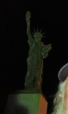
Moving down to Grady County, we get our last cache for the day. A virtual geocache for another one of those miniature Statue of Liberty monuments (GCFC05).


We finish the day near midnight finally getting some sleep down in Lawton, OK. Twenty-eight geocaches, about a dozen new counties, and nearly 18 hours later I'm exhausted! But it was a great day for geocaching and sightseeing through history.

Until tomorrow... ZZZzzzzz........