Showing posts with label creative. Show all posts

Tuesday, October 27, 2020

2019-02-06: Finally Completing the Texas Counties After 13 Years!

YAY!! It only took me 13 YEARS to complete!! Being a Florida resident, we were traveling around in an RV and when we got to Fort Davis I remembered my sister telling me about this Geo treasure hunting game. Well our DataStorm satellite gave me coordinates wherever we were parked. So without a GPS, my son an I made 3 attempts hiking the trail before finding the cache on April 18, 2006. You can read all about that in a blog post here: http://awaywego.us/adventure_archives/04-19-06.html


Continuing West to California, north to Alaska, east to Maine, and then back to Florida, I would not see another Texas cache until July 2007 when I became a truck driver. Picking up some caches here and there as long as I can find Big Rig friendly caches, my last Texas cache as a truck driver came in April 2010. That started a dry spell as I would not step foot in Texas again until November 2015. (That's all in my original blog linked above.)

When I first arrived back in Texas this time, my wife and I were in Jasper (East Texas) for 6 weeks until her company transferred her to Lubbock. We were there for 3 months and then transferred again to Crane for 18 months. From there she went to Killeen. My new job had me working in West Texas, then down to the Rio Grande Valley. So I pretty much covered the state! (You can read all about that in this blog.)

I had the final 3 Texas counties: Hood, Dallam and Sherman. Hood was SW of Fort Worth and just a few hours away. But Dallam and Sherman Counties were WAYYY up in the top west corner of the panhandle. We just did not have time for them on that caching run while we were in Lubbock. I knew they would be haunting me and I almost had to leave them behind.

I finished surveying the wind farm project in the Rio Grand Valley (yeah my work involves a GPS also!) on January 25th and they wanted me to start in Missouri last Monday on the 28th. YIKES! No way I can grab those unless I took the REALLY long way around. Well as luck would have it, the last minute they told me to hold off on going to Missouri. So I decided I'd better run up there quick while I have the chance before they assign me my next project location.

A couple days ago I hit the road. Going north up I-35, I stopped for gas in Alvarado, Texas. Nearby was a large cemetery with two geocaches. I found them both (GC5ZMG5, GC5QRGJ). I mean you can't pass up a cemetery cache when you're that close right!

Then I finally arrived in Hood County and Acton Cemetery. Acton had four caches, one of which was for a famous resident; Elizabeth Crockett (GC6XKHC). Acton Cemetery is also the location of Acton Historical Site which is the smallest Texas State Park. The park basically consists of the grave of Elizabeth P. Crockett (1788-1860), widow of Alamo Hero David Crockett, and two of his children. In 1911, a statue and monument were erected to her memory and made a state park.


Acton (formerly called Comanche Peak) was named in 1855 by C. P. Hollis, the first merchant in town. In spite of the early name, Acton had few Comanche raids. After erecting a building for church and school, early pioneers selected this plot for a cemetery. The first person buried here was Mrs Wash Hutcheson in 1855.

A few more quick caches along the roadside before arriving up in Dalhart, Texas for the night and checking into the hotel.

Yesterday morning I'm up and out just before dawn. Dalhart has some creative caches in town and I wanted to get to them before the local muggles would hinder my search. The geocaches were called "The Valve of Life" (GC4YDEY), the "Denver and Rock Island Switch" (GC55P4B), and the "Dalhart Volunteer Fire Department" (GC58BMN). Combined they have well over 1000 visits and over 600 favorite points! And they get me one of my last two remaining counties!

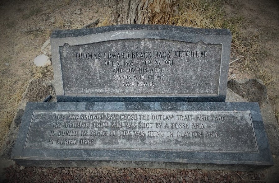
Now the road to get to the tri-state corner, which I'll get to in a moment, goes into New Mexico before back into Texas. I already had that county for New Mexico, but I didn't want to pass up this cemetery. Clayton Cemetery contains the grave of "Black Jack" Ketchum (GC1KD22). Thomas Edward Ketchum (October 31, 1863 – April 26, 1901), was an ordinary cowboy and cattle driver who later turned to a life of crime. Black Jack Ketchum became one of the most famous outlaws in the region. He was captured when he single-handedly attempted to rob the same train again at the same place and in the same way that he, his brother Sam and others from the gang had robbed it just a few weeks earlier.

The train conductor, Mr. Frank Harrington, saw Tom approaching the moving train. He recognized him, grabbed a shotgun, and shot Tom in the arm, knocking him off his horse. The train continued, and the next day a posse came out and found Tom beside the tracks, badly wounded. He was transported to medical facilities at Trinidad, Colorado and his right arm had to be amputated. He was nursed back to health and then sent to Clayton, New Mexico Territory, for trial. In 1901, Black Jack was sentenced to death and hanged at Union County Court House for all his crimes and his last attempted train robbery. Black Jack's last words were: "I'll be in hell before you start breakfast, boys! Let her rip!"


Next up is a physical cache at the NW corner of Texas bordering New Mexico only (GC2VPKZ). You don't really notice it on most maps because it's just a slight overhang of about a mile where New Mexico goes over top of Texas before bumping into Oklahoma. So you have that marker and then about a mile to the east is the tri-state marker connecting Texas, New Mexico, and Oklahoma. And that is a virtual geocache pictured below (GC9374). I just had to wear the black hat for that one!


So now I'm kinda zig-zagging between Texas and Oklahoma picking off the Oklahoma border counties as well. A quick roadside cache (GC4J62V) and a cemetery cache (GC146NC) for Cimarron County. Then I dive down into Sherman County, Texas for my final of the 254 Texas counties (GC4JYTD)! WOHOO!! My second completed state and it ONLY took 13 years to do so! LOL

Picking up seven more cemeteries and two quick roadside caches in Oklahoma before I get to the Shattuck Windmill Museum virtual geocache (GCGBM4). There are windmills of all kinds dating back to the 1800's. A whole lot smaller than the 300' turbines of today!


A few more quick caches yesterday after that and I found the nearest hotel just as it was getting dark to stretch out and relax.

This morning I grabbed a cache (GCMHHX) here in Altus, Oklahoma for Jackson County before crossing the border into Texas. Continuing southbound on US-281 towards Killeen, TX, I spotted this world's largest rocking chair and a virtual cache (GCGYEB).


One more geocache to show you on my drive back home today. This simple bird house looking geocache was easy to find (GC6Q8PT). The tricky park was getting it open to sign the log. After a few minutes I figured it out this gadget cache and had my hands on the prize.


So I completed my Texas Counties on February 5th, 2019! YAY!! That brings my total counties to 1024 with Texas and Florida completed. Hopefully by years end my job transfers me to a solar project in Virginia where I can work on another state. Stay tuned for what's coming next...

Saturday, September 12, 2020

2018-09-12: Completing Geocache Counties Along the Texas Gulf Coast

Welcome back to the Rio Grande Valley in South Texas on a wet Wednesday. It's still too muddy at the jobsite to work. So it looks like another day of Geocaching! And I've got just the thing. I've been working on completing my Texas counties. There are a total of 254 counties in Texas. I need two at the very top of the panhandle, two north of Dallas, and there are four left here along the Gulf Coast.

I quickly get underway across the state, I've got a lot of driving to do today. My first stop is a geocache (GCQJCF) at a historical marker in Matagorda County. Camp Palacios was established on this site in 1925 as the summer training camp for the Texas National Guard's 36th Division, which had formed during during World War I as the 36th Infantry. The division, which became the 36th Infantry Division during World War II, trained here each summer, 1926-1937 and 1939. Located on the Turtle and Tres Palacios Bays, the land was donated by Palacios area citizens. More than 6,000 guardsmen arrived in July 1926 for the first training session. In 1930, the camp was renamed for Major General John A Hulen (1871-1957).

On its 1,200 acres, the new camp supported the largest concentration of troops for field training in the United States Military, with facilities for several thousand inhabitants. In 1940, the War Department leased camp Hulen; first to undergo Anti-Aircraft training were National Guard units from several states. By 1941, the City of Palacios suffered a housing shortage that was alleviated by Government housing for military families and civilian workers near Camp Hulen. After extensive development, the camp had facilities for 12,000 military personnel.

Basic training continued until early 1944, when U.S. Soldiers were removed. German prisoners of war, guarded by a small contingent of U.S. personnel, were housed here from 1943 to 1945. In 1946, the War Department returned Camp Hulen to the National Guard, for whom it had become too small. Buildings were slowly dismantled and sold. In 1965, the property was sold jointly to a group of Palacios citizens and a development company.

Next stop in Port Lavaca, Texas over in Calhoun County, I come to a virtual geocache (GC84D1). Constructed in 1858 this three-story hexagonal lighthouse was originally located in Matagorda Bay, at the southern tip of Half Moon Reef. The beacon served as an aid to ships trading in Port Lavaca and nearby Indianola. The beacon was in service till 1943 when it was moved to Point Comfort, then moved to it's present site in 1979. The beacon was restored as a community project and placed on display.


Also in Port Latava is another virtual geocache of historical value (GCG8JQ). At the VFW Post 4403 is a Vietnam War Memorial. This Army helicopter saw action in Vietnam and Desert Storm. It has the capability of carrying two tons of ammunition to fire from machine guns, cannon and grenade launchers. It had the distinction of being the most heavily armed helicopter in Vietnam action. This swift and hardy craft became one of the most celebrated tools of the Vietnam War.


The last virtual geocache here was at Indianola, Texas (GCDFB7). Of the many ghost towns of Texas, none lived longer, none thrived better, none died as tragic a death as Indianola, on the west shore of Matagorda Bay near where Rene Robert Cavelier, Sieur de la Salle, is thought to have landed in 1685. Many colonists, including the German immigrants led by Prince Carl of Soms-Braunfels entered Texas at this natural port. It was an important military port, a railhead, and a diplomatic center where commissioners of Mexico and the United States met to establish boundaries proscribed by the Treaty of Guadalupe Hidalgo. The port exported cattle to the East and Cuba. In 1875, at the heights of its prosperity, population 6,000, a tropical storm took toll on lives and property. After a second storm hit a year later Indianola was abandon. Now only a fishing and vacation community remains of this famous Texas city.


Next up in Refugio County was my next geocache at the Tivoli Cemetery (GC4NHZ7). Captain Newton Cannon Gullett who founded Tivoli, Texas on his ranch of the same name. Gullett erected a cotton gin, store and a boat landing on the Guadalupe River to export cotton and receive supplies. 

The town was first platted in 1907 by Preston R. Austin and a post office was granted in 1912. The St. Louis, Brownsville and Mexico Railway was extended through Tivoli (to the terminus at Austwell) that same year. The town was re-platted in 1913 - doubling the size of the town from five blocks to ten. Austin donated the town's first church and school. Hurricanes hit Tivoli in 1919 and 1942, but the shallow bay, high bluffs and slight population spared the community from obliteration. The town reached its population zenith in 1928 with a population of 700. The next photo is one of the old abandoned houses in the town.


Continuing to make my way back, I enter into Aransas County and the historic Lamar Cemetery (GC188TK). According to the historical marker, this burial ground originally served members of the Lamar Community. Founded by James W. Byrne (d. 1862), a native of Ireland and a veteran of the Texas Revolution, it was named for his friend Mirabeau B. Lamar, President of the Republic of Texas from 1838-1841. The earliest grave is that of Patrick O'Connor (1822-1854), a bookkeeper for Byrne's business operations in New Orleans. The town of Lamar ceased to exist by 1915 and the cemetery was neglected until the 1940's when it was restored through efforts by the family of John Henry Kroegor, Jr (d. 1944).


Crossing the bay down into Fulton, Texas, I found my next geocache in the Fulton Cemetery (GC188TK). Land for this community graveyard was set aside when the town of Fulton was platted by George Ware Fulton in 1868. The earliest documented burial is that of a child, Louis L. I. Greenough (1868-1869). The large number of children's graves attests to the often harsh conditions of pioneer life. Also interred here are European immigrant settlers, prominent local citizens, and veterans of the Civil War, World War I, World War II, Korea, and Vietnam. A brush fire in 1947 destroyed many of the early wooden markers, leaving some unmarked graves.


Just before crossing the bridge into Corpus Christi, in the town of Portland, was another geocache (GC58B90) call "Home Sweet Gnome" that had a lot of favorite points given to it. So I just had to go and check it out. It was a very creative cache someone constructed out of a tree stump.


Heading west now making my way back to Falcon Lake, I make a stop in the town of Alice to grab a geocache at the Collins Cemetery (GC119Y1). Alice, Texas is the town originated in the defunct community of Collins, three miles to the east. About 1880 the San Antonio and Aransas Pass Railway attempted to build a line through Collins, which then had 2,000 inhabitants. The townspeople were not amenable to selling their land to the railroad company; consequently, the railroad site was moved three miles west, and in 1883 a depot called Bandana was established at its junction with the Corpus Christi, San Diego and Rio Grande Railway. Bandana soon became a thriving cattle-shipping point, and application for a post office was made under the name Kleberg in honor of Robert Justus Kleberg. The petition was denied because a town named Kleberg already appeared on the post office list, so residents then chose the name Alice, in honor of Alice Gertrudis King Kleberg, Kleberg's wife and the daughter of Richard King. The Alice post office opened for business in 1888. Within a few years the remaining residents of Collins moved to Alice, which was by then a thriving community.

My last geocache was in a town called San Diego, Texas (GC78TC9). Early travelers between Goliad and Mier stopped to use the springs that fed San Diego Creek in what was to become San Diego. Around 1800 Julián and Ventura Flores (father and son) received two land grants known as San Diego de Arriba and San Diego de Abajo. The grants were surveyed in 1806 and they received their deed in 1812. In 1828 the first birth was recorded and the population was estimated at 25 families by 1844.

In 1846 Gen. Zachary Taylor and his troops briefly occupied the town during the Mexican War. In 1848 Ventura Flores sold land to Pablo Pérez, who built houses and named the town Perezville. The town's first post office was opened in 1852 in a small white building known as the Casa Blanca. It is said that Perezville was renamed San Diego at this time. This building was occupied by Confederate forces during the Civil War and it later served as a store, a speakeasy, a residence and a bar. It remains standing today.

Grabbing a bite to eat as well, it was still nearly two hours of driving back to the house at Falcon, Texas. After 600 miles today, I have completed the last of the southern Texas counties! Only a few more to go up north to complete the state. Thank you for riding along with me. I welcome you back again soon for another days adventure.

Tuesday, January 21, 2020

2018-04-08: Geocaching Across Central to West Texas

Welcome back to AwayWeGo's Geocaching Adventure Blog. For those that don't know, I started using AwayWeGo back in 2005 when my sons were 8 and 10 years old. At the peak of the real estate boom, we sold our house and bought a motorhome. For the next 11 months we just traveled the country from Florida to Maine to California up to Alaska. You can read about that adventure by going to AwayWeGo.US. Click on the "Our Adventures" in the menu for the archives. The AwayWeGo.US is also my Geocaching name.


OK, so much for reminiscing. Today's 360+ mile Sunday drive from Killeen back to Monahans, Texas, had me stopping by a couple cemeteries, an old church, a roadside attraction photo opp, the geographic center of Texas, and has Christmas died?

My first stop was at the Copperas Cove Cemetery at a cache called "Nineteen Forever" (GC1G31T). The hider has a brother buried here who died in 1989 at the age of nineteen.


One more before leaving Copperas Cove. A quick guard rail cache called Keyless Entry (GC11JGE), but not what I was expecting.  It kinda threw me off a little. But then it finally hit me like "what's the purpose?" Duh! I guess I should have reconsidered the name of the cache. A round rusty magnet covering the key/cache hole. Nicely simple creative geocache.


Continuing on to Lampasas, Texas, there was a new puzzle geocache (GC7MJC7) that had not yet been found after three days. So a chance at a First-To-Find! Most puzzle caches I take a quick look then ignore because they can be so complicated you need rocket scientist to decode them. But this one wasn't one of those. I arrived at the given coordinates and looked around for some numbers in the line of sight. Getting the information needed, I input the new coordinates which took me over to Hancock Springs Park. At the entrance to the park is the Worlds Largest Spur. After taking a few photos, I found the cache and a nice clean logsheet! YEA a FTF!


Along the way to my next geocache, I found myself on some very rural backroads of Texas north of Richland Springs in San Saba County. While enjoying the drive, I noticed a sign pointing down a side road that said cemetery. Hmmm... so I don't recall another geocache being along this route and I don't have cell phone service to verify. But I gotta go investigate no matter what.

A short distance later, I find myself in the Bowser Community. About 1858 the Abel Bowser family settled at a large bend in the Colorado River about 3 miles north of this area. The developing village, school and cemetery became known as Bowser Bend and by the late 1880's included a cotton gin and store. Due to river floods, Paul Varga donated land at this site for a chapel and cemetery in 1890. In the early 1900's J. T. Martin sold town lots and deeded land for a school one-half mile east. The town of Bowser relocated, but the closure of the post office, gin and school caused it to decline in the 1940's. Recent population has it around 20.

I spotted this old homesite that had fallen in on itself. The only thing that's held up are the two chimneys at each end of the house. I've seen a few of these towering chimneys with nothing else around. In Odessa, Texas, there's even one at the edge of a shopping center parking lot. The only remains of an early pioneer homestead.


Then there's this small church that looks like it's had some additions and improvements over time. The lower right corner of the stone building has a plaque that says: "The Methodist Church, 1941, D. G. Hardt, Pastor."


Finally, I arrived at the Varga Chapel Cemetery which brought me down this way. This is the cemetery I mentioned above on land donated in 1890. Since there wasn't a geocache here already, I decided to hide one myself. Walking around through the headstones, I was looking for something of interest and a reason to highlight this cemetery. Then there it was! Of all the many cemeteries I've been to, I don't recall ever seeing this family name. I found a spot to hide the geocache container and "Bah Humbug! Christmas is Dead!" was created (GC7MRW5).


Remember as a kid when your mother
used to tell you not to eat the seeds
because trees would grow in your stomach?
Well...


OK, time to get back on track continuing on towards the geocache (GC5PFE3) I was headed for! I thought this next one was going to be cooler than it turned out to be. What I did find was a historical marker. It read as follows:

"Five miles northwest is the geographic center of Texas,..." WAIT! WHAT? FIVE MILES NORTHWEST!? So as it turns out, this marker is NOT the geographic center. The TRUE center happens to be located on private property. So NO marker to visit there. Oh well. Here's the rest of the text you'll read on this historical marker just in case it might appear on a Jeopardy question or trivial pursuit.

"...an imaginary point whose coordinates divide the state into four equal areas. In straight-line distance it is 437 miles from the state's most westerly point on the Rio Grande River above El Paso, 412 miles from the most northerly point in the northwest corner of the Panhandle near Texline, 401 miles from the most southerly point on the Rio Grande below Brownsville and 341 miles from the most easterly point on the Sabine River near Burkeville. Maximum border-to-border distance is 801 miles from north to south and 773 miles from east to west.

"Enclosed within the 4,137-mile perimeter of the state are 267,339 square miles or 7.4 per cent of the nation's total area. Fifteen of the 50 states could be readily accommodated within Texas' borders--with more than 1,000 square miles left over. Brewster, in southwest Texas, is the largest of the state's 254 counties with 6,208 square miles, an area larger than the state of Connecticut. Smallest county is Rockwall in northeast Texas with 147 square miles.

"Texas elevations rise from sea level along the 624-mile coast of the Gulf of Mexico to 8,751 feet atop Guadalupe Peak in the Guadalupe Mountains. Altitude at this point is 1,545 feet. Terrain varies from the subtropic Rio Grande Valley to the trackless Great Plains, from the lush forests of East Texas to the rugged Trans-Pecos region where mountain ranges thrust 90 peaks a mile or more into the sky. But perhaps nowhere are Texas contrasts more pronounced than in average annual rainfall: from more than 56 inches along the Sabine River, nearly as much as Miami's, to less than 8 inches in the extreme West, as little as Phoenix's."


By now it's after 1PM and I still have almost four hours of drive time plus several more potential FTF's to get near Midland. So I quickly drive through San Angelo all the way to Sterling City. I stop at the DQ to finally get a late lunch and grab the geocache at the park across the street (GC5132R). And well since I've stopped anyway how about another quick one just 2 blocks away (GC52CRT).

Just southeast of Midland and I arrive at "What Am I Doing Way Out Here?" (GC7MPT9), where I find a nice clean logsheet at 5PM. WOHOO a FTF!! I looked up the cache owner and saw she had some more new caches out here in this area.

I found "Finally Got a Signal" (GC7MC5X) and "Down That Long Dirt Road" (GC7MC63), where I managed to get 2nd to find on each of those. Then it was "One Noisy Windmill" (GC7MPT2) and another FTF at 5:30PM.

Now it came down to: do I go after 6 more FTF's in the wrong direction towards Big Spring OR go west towards Monahans for only one more FTF? It had been a long day of driving. So westbound it is to the "Nice Little Pit Stop" (GC7MPT5) at a new Dollar General store for my final FTF at 6PM.

Another hour later and I finally make it back home to Monahans. Thanks for riding along with me. See you next time...

Thursday, December 19, 2019

2018-03-11: Ghost Towns, Cemetery, a Gadget Geocache and More

Well here I go again. Another Sunday and another long drive back to West Texas. With some Geocaching stops along the way to break up the 360+ mile drive. Getting a little bit of a later start, I didn't want to get side tracked and spending a lot of time geocaching close to Killeen. So upon leaving home, I drove non-stop to San Angelo where I make my first stop at Starbucks.

Then heading SW on US-67 a few miles down the road by the Twin Buttes Reservoir, I make my first Geocaching stop at "A Little Bit of Sprinkles in San Angelo" (GC5BPYX). After a little bit of a search I came up empty. This one hadn't been found in nearly two years and had several DNF's. And now I've also added my DNF.

Just down the road was another cache called "Burt's Bees" (GC3XXXE) that previous finders also couldn't find. One of which said there was a damaged container. So I gave it a look because it had a few favorite points. Sure enough, I found what was left of a damaged container and nothing else. So I logged my 2nd DNF of the day and a "Needs Maintenance." Uggh! 0-2 is not a good way to start the day.

Back on US-67 a little ways and I get the smiles again. I guess you could call this one an easy gadget cache or just a very creative geocache. Called "Hickory Dickory Dock" (GC6Q5QC), it's just one of those fun creative caches that someone put some thought into.


Then I found the nearby "Old House Gone" geocache (GC11J8E). I'm not exactly sure about the real history here. I don't think it was once a real house now gone. But it looked more like an urban outdoorsman camp. There was the remains of a mattress (just the metal springs), an old couch, and lots of old rusty tin cans scattered about.

One more quick geocache "To the Ramp and River" (GC1B6RP) around the Twin Buttes Lake area and I'm finally moving westbound again.

The next two geocaches on my list were for the Arden Community ghost town (GC113HK, GCMJ22). Arden, on Rocky Creek was named for John and Katie Arden, who settled a claim at the site by 1885. The community acquired a post office in 1890 with W.P. Moore as postmaster. A local public school was established in 1892. Two short-lived schools had operated before this in Arden district, one on Rocky Creek and the other at Sawyer. In 1915 Arden had a post office, a school, a church, and a population of fourteen. In 1947, when the community had one business and thirty residents, the Arden School was consolidated with the Mertzon. All of the businesses had been abandoned as of 1966, execept for a polling place used to preserve precinct lines. The passing of the school, low cotton prices, drought, and better opportunities in nearby larger towns were the primary causes for the decline of Arden. The 2000 census listed only one resident remaining. Since 1952 an Arden reunion has been held each Labor Day on Rocky Creek.


The photo above is where the school used to sit. The photo below is of the Arden Cemetery which contains just 44 burials and is still in use to this day.


In trying to make my way back to US-67, I passed by "Middle Concho Crossing" (GCMN76). A low water crossing for a creek but it was dry here today. That one was followed by another "Just Over the Hill" (GC11KTE).

Passing through Mertzon for a few miles to the south I arrived at the ghost town of Noelke (GC15Y5N). From the cache page: "Noelke is on the Atchison, Topeka, and Santa Fe Railroad and a local road ten miles southwest of Mertzon in south central Irion County. The small settlement began as Monument Switch on the Kansas City, Mexico and Orient Railway when the road built through the area in 1910. The community was renamed Noelke in 1933 in honor of a local ranch owner, Walter Montgomery Noelke. The Monument switch continued in service in Noelke for some time after that, but county maps of the 1980s show only the location of the Noelke community. According to a local resident there was never a town here. Locally it was known as Noelke Switch. The Monument name came from a nearby mountain of the same name. The only building he was aware of was the railroad man's home which is gone. Old cattle pens are all that remain as this was the main place in the area for loading cattle for transport. Today trains pass through the area about twice a week on their way to Alpine. The ranch land for miles around is still owned by the Noelke family."


Around the curve a few miles away was my last stop and another ghost town called Pumpkin Center (GC15Y5Q). Again from the cache page: "According to a local resident, Pumpkin Center consisted of a store where area residents could get basic supplies and pick up mail. It was located at the junction of two county roads and along the Atchison, Topeka, and Santa Fe Railroad. The railroad switch at this spot was known as Suggs Switch. Nothing remains at the location. With the establishment of Mertzon, Pumpkin Center ceased to be."

That's it for me today. Still had 140 miles to go from here. Better get moving cause it's getting late in the afternoon. I hope you enjoyed the ride. See you next week...

Wednesday, February 10, 2016

2015-09-07: Labor Day Weekend Geocaching in Georgia

YAY! It's a long 3-day weekend for Labor Day. That calls for a Geocaching road trip! Hmmm... where to? One of our goals is to complete our Geocaching by county map. With Florida already completed, the next closest is Georgia. So a Georgia road trip is the order of the weekend. So we pack the bags, head up I-4 to I-95 north. When we arrive in Jacksonville, we exit onto US-23 up to US-301.

Our first stop is in Folkston, GA and Charlton County. We continued up US-301 north picking up caches within each new county. Reaching Statesboro, GA, we decided to call it a day. On day #1 of this weekend road trip, we picked up 9 caches.

Yesterday started out with a few VERY creative caches put out by one cacher down the same dirt road. Even though we already had the county, there are some you can't bypass. I won't explain them, but the next few photos are the caches. A couple of them took a little detective work figuring out how to get them open and finding the log sheet in order to sign it.


We stayed on US-301 all the way up towards the SC state line in order to get a cache at the Georgia Welcome Center. This is the OLDEST welcome center still in use in the country, opening in 1962!


After the Welcome Center, we did a u-turn back south to GA-25 west. Then following some rural back roads we found another creative cache using a gator head at McKinneys Pond and Mill Creek. On the property was also this old house about to fall into the creek.


A few more caches here and there picking up new counties, we made our way over to the town of Jackson. There along Lake Jackson and the Lloyd Shoals Dam was the "Cache Across America" for Georgia. It was a nice little hike through the woods. Even the GeoDog Max got in on the action here. From there we drove down to Macon and called it a day, having found 14 more caches and more counties.


This morning waking up in Macon, it was the last day for our weekend road trip. We had some more caches and more counties in the works before arriving at home back in Florida. We followed US-80 south down to GA-26 over to US-23 south. It was a great weekend. We found a total of 32 caches for the weekend and 20 new counties for Georgia. A lot of history, some hiking, and some unusual and creative caches.