Showing posts with label gas station. Show all posts

Saturday, May 15, 2021

Exploring the History of Gilliland, Texas and is it a Ghost Town

Hello and welcome back to another edition of AwayWeGo's Geocaching Adventures. This is one of those blog posts that is a little different than my usual roadtrip stories. After leaving North Carolina, my next construction project brought me to this little town of Gilliland, Texas. For the two months I was here, I got to explore some of the area and take a look into Gilliland's past through some of the abandoned buildings. 

I don't know if I would call this a ghost town or not since at best it reached 120 residents at one time. Now it's down to just 25. But with some of the creepy abandoned buildings, I'll let you decide.

An old abandoned farm house.

There were no Geocaches here for me to find, but I did manage to hide a few myself to bring other Geocachers to this small community to discover what I've found.

Gilliland is located on Farm Road 1756 some seventy miles southwest of Wichita Falls in north central Knox County. The first Anglo-Saxon to arrive to this area was probably was a surveyor (like myself) named Captain Randolph B. Marcy who was commissioned to look for a suitable site for a wild Indian reservation. In 1870 Indians were making forays taking food or spoils or just pillaging. In 1871 the first settlers, who began arriving in covered wagons seeking new opportunities, called the community Coyote on the land between the north and south forks of the Wichita River. Wagon trains brought families who lived in tents, two room picket houses, wagons, and half-dugouts. 

Settlement came in waves by men mostly of European culture until the arrival of a nearby railroad which paved the way for a population explosion. Over the years the area gained a mix of settlers from various locations, including several Norwegian families from Bosque County, who arrived in 1890. Stores, homes, churches and schools sprang up to provide the settlers needs.

The Gilliland school district was established on May 1, 1892, and school began in 1895 with Miss Oma Acker as the first teacher. Over the years several schools were consolidated with the Gilliland district after the now abandoned school building (GC8AN63) was erected in the 1930's. Gilliland's new school featured numerous classrooms, a cafeteria, and a gymnasium that doubled as an auditorium for plays and assemblies. In 1948 its high school was transferred to Munday, leaving Gilliland with only a grade school. It continued until finally closing its doors in 1975.

The Abandoned Gilliland School Gymnasium / Auditorium

District judge W. A. Gilliland became the town’s namesake when the opening of a post office in 1907 required an official name. In 1910 Luther Burgess, Jake Cure, and W. A. Cure built a cotton gin just outside of Gilliland. The gin was modernized in 1936 and proved to be highly productive. Leading settlers included O. M. Olson, who operated a post office in his home in 1907; F. B. McGuire, owner of McGuire's General Store; and longtime postmaster J. S. Cook, owner of three businesses between 1926 and 1934.

Gilliland had an estimated population of fifty in 1925. By 1947 it reported 120 residents and four businesses. In 1971 it had three businesses, and from 1971 to 1990 its population was reported as 103. By 2000 the population had dropped to twenty-five.

Today the community consists of the ruins of the 1930 school, grain silos and a few former businesses being reclaimed by nature – although the community center is in good repair and still in use for meetings and a voter polling place.

The Gilliland Cemetery (GC8AN86) is a well kept still in use cemetery with over 330 interments to date. The one grave that stuck out here is for a man named Liberty Justice who died in 1925. I tried researching this man for a few hours but didn't come up with anything but his spouse and children's names.


So while working here in Gilliland, I'll be living about 20 miles south in the town of Munday. Over the next few weeks I'll be bringing you stories about of my weekend roadtrips between here and Killeen and all the places I've discovered in between.

I leave you with a few more photos from Gilliland:

The Abandoned Gilliland School Gymnasium / Auditorium

Swing-set behind the school and abandoned house.

East-West Hallway of Abandoned School

Front Entrance of Abandoned Gilliland School

Front of Abandoned Gilliland School
You can get a look of the walled entrance which prevented cows from wandering inside.

Abandoned gas station with Esso gas pumps.

Abandoned General Store

Abandoned Former Store or Garage?


Side Door of Abandoned Gilliland School

Abandoned Farm House

Abandoned Old Ford Trucks left in field.


Inside Abandoned Farm House

Abandoned Farm House

Abandoned gas station with Esso gas pumps.

Hwy 267 going south to Munday

Saturday, January 30, 2021

2019-05-04: Moving Day Roadtrip from Texas to North Carolina Day 2 in AL, GA, & SC Historic Cemetery, House, and Gas Station

Well after 16 hours of driving and geocaching yesterday, it's time to hit the road again for day two of my roadtrip from Texas to North Carolina. Todays drive will take me from Alabama, through Georgia, to South Carolina. So jump in and let's see what we can find!


My first stop was for the "Trussville Civitan" Alabama's First Geocache (GC126). This cache was hidden way back on January 2001. The are only 48 geocaches left that were hidden during that month. For geocaching statistics, there's a Jasmer Calendar that lets a cacher know what months their found caches were hidden in. I only had one open spot for 2001 and it was January.

So I arrived near the geocache location in the parking area of a park. At the center of the park was this Veterans War Memorial. Took a quick photo before I went for a walk.


There was a walking and biking paved trail down along the Cahaba River. There were quite a few people out getting their morning exercise along that trail. I'm more interested in what was in the woods and headed for that. Only a few hundred feet in and away from the curious eyes of the muggles, I found the 18 year old prize that has been found nearly 1700 times and added my name to the log. YAY! Now just two more spots for July and August of 2000 to fill in the blanks. Even harder as there are only seven of those in the United States.


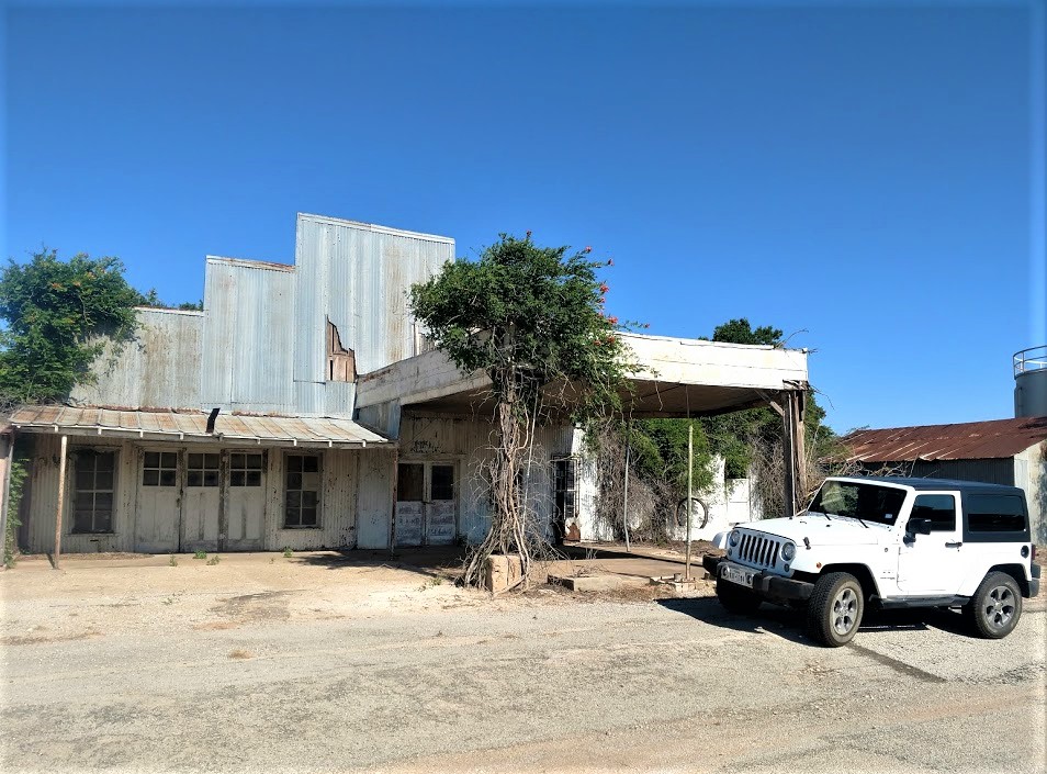
Before leaving town I spotted this old gas station and just had to stop for a photo. The building was originally constructed as a Gulf Service station in the late 1950's. In 2013 the building was bought by Rocky Neason who turned it into the Classic Cars and Garage Museum. The station was transformed into a Standard Oil Gas Station replica and filled with many 50's & 60's era antiques collected by Rocky Neason during his 31 years in the industry. There was a 50's 2-seater T-Bird and a 60's mid-year Corvette behind the bay doors during my visit. But I understand the cars get traded out with his collection from time to time.


Moving along for a cache in St. Clair County, Alabama. "Final Resting Place" (GC7ETF0) is a geocache located in the Moody Cemetery. There are over 900 interments here dating back to 1860. With the muggle here mowing the lawn, I just found the cache and moved on.

A few quick park and grab caches for Calhoun County (GC82XM4, GC36J12) and a Dunkin Donuts coffee. Crossing the state line into Georgia, I exit I-20 for two more quick caches in Carroll County (GC7F5J3, GC7F5GY).

Now I'm in downtown Atlanta. Not my favorite place to be. But there are some "must do" geocaches there. Fortunately it is Saturday so traffic isn't too bad. The first is a D5/T5 challenge cache called "The Lower 48 States" (GC5EQQT). Located a couple blocks from the state capital, it is an easy cache to find yet a very difficult cache to claim. It requires you to find at least one cache in each of the lower 48 states. I've managed to find one in 49 states, only missing Hawaii.

Then I take a drive over to the historic Oakland Cemetery. It was established in 1850 as the Atlanta Cemetery on 6 acres of land southeast of the city. It was expanded to 48 acres by 1867 and renamed in 1872 to reflect all the oak and magnolia trees. The magnificent entry gate pictured below was constructed in 1896. From 1936 to 1976, the cemetery is neglected and fall into disrepair. The cemetery was placed on the National Register of Historic Places and a restoration began. Eventually the Historic Oakland Foundation was created and maintains the grounds. An average of 105,000 visitors tour this cemetery every year. Today it is my turn.


There are two virtual geocaches there. The first one I found is for "The Master" (GCD42A). The geocache is dedicated to one of golfs greatest players, Robert Tyre "Bobby" Jones, who won multiple Masters Championships in the 1920's. You'll find his headstone at the coordinates.

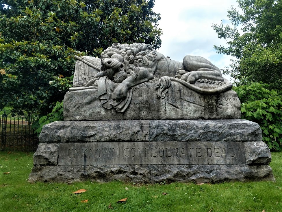
The other virtual geocache is called "The Lyin' Cache" (GC64DF). Oakland’s most centrally located character area is the final resting place of approximately 7,000 Confederate soldiers, many of whom are unknown. Following Oakland’s acquisition of additional land, this four-acre portion of the cemetery began its transformation in 1866 by the Atlanta Ladies Memorial Association (ALMA). Several hundred of these graves were originally marked by simple painted wooden headboards, then replaced by marble markers with rounded tops in 1890.

Near the center of the Confederate Burial Grounds, Oakland’s tallest monument is a sixty-foot granite obelisk memorial to the Confederate Dead. Erected by the ALMA, the foundation of Stone Mountain granite was laid in 1870, on the day of the funeral of Robert. E. Lee. The monument wasn’t completed and dedicated until Confederate Memorial Day, on April 26, 1874.

Flanking the obelisk to the northeast, the Lion of Atlanta monument commemorates unknown Confederate soldiers who died in the Battle of Atlanta. The large sculpture carved in marble from Tate, Georgia was commissioned by ALMA and unveiled in 1894. With the famous Lion of Lucerne as his model, T.M. Brady depicted a weeping lion, representing courage, dying on a Confederate flag.


(Jumping ahead to 2020... Sadly, political and civil unrest has led to vandalism of this nearly 130 year old memorial. On the nights of May 28, May 31, June 5, and June 6, 2020, members of BLM and Antifa went into Oakland Cemetery and vandalized the Lion statue, the Obelisk, some of the headstones, and one of the historical markers within the Confederate Burial Grounds. The geocache has been archived.)


The monument at the Neal family plot is one of the most beautiful in Oakland Cemetery. Mary Elizabeth (Lizzie) Neal was the daughter of Thomas Neal and Mary (Mollie) Cash. Before moving to Georgia from Louisiana three years earlier, she lost six siblings. She suffered from rheumatism for several months before her death. Her sister, Emma, cancelled a trip to the Arctic to care for her Lizzie in the last days of her life. Created by her father after her and her mother's deaths, Lizzie is thought to be represented by the woman on the right of the monument.


Three more interments here worth mentioning. Joseph Jacobs (1859-1929) was a businessman and pharmacist. While it was John Pemberton who invented Coca-Cola in 1885, it was Joseph Jacobs that introduced it to the public on May 8, 1886.

Also, there's Margaret Mitchell (1900-1949), author of the book "Gone With the Wind." On August 11, 1949, she was hit by a drunk driver while crossing the road at Peachtree and 13th with her husband on the way to see a movie. She died eight days later.

Finally, and jumping again forward to 2020, singer, songwriter, and actor Kenny Rogers was laid to rest in Oakland Cemetery on March 20, 2020.

All in all there are estimated to be about 70,000 interments here. I spent almost two hours exploring this cemetery and didn't get see it all. But I do need to get back on the road. It's late in the afternoon and I still have ground to cover. So let's get moving.

The next six geocaching stops were quick roadside or parking lot caches to get six new counties in Rockdale County (GC5GT56), Newton County (GC84173), Walton County (GC2X92M), Greene County (GC1AFQN), Taliaferro County (GC19WT6), and Warren County (GC1DZ99). Along the way traveling down these backroads, you often see houses or buildings that have long been abandoned and nature is consuming them. If you're anything like me you begin to wonder what they once were and what happened that allowed them to get to this condition.


Continuing over into McDuffie County we stop for some history. "The Rock House" (GC21JD6) is an 18th Century stone dwelling and is the only surviving house associated with the Colonial Wrightsboro Settlement (1768). Its builder, Thomas Ansley, used weathered granite, quarried in its natural form from the nearby geographic fall line, as building material. The granite, along with pine timbers and cypress shingles, gave the house a distinctive Georgia character. The architectural style of the Rock House is similar to stone houses in the Delaware Valley of New Jersey from which Ansley migrated. It is the earliest dwelling in Georgia with its original architectural form intact.

The home is now owned by the Wrightsboro Quaker Foundation and has been rumored to be haunted. The Augusta Paranormal Society visits this location from time to time.


Across the street is a large monument erected in 2002 among many small crosses. "The great tornado (Type 5) entered McDuffie County at RR Mile Post 42. At 12:45 PM, March 20, 1875 the Rock House lost windows, a cook house, corncrib and gin. In the center of the cemetery a giant oak was blown down. This marker was in the center of the tornados path." There are 18 names with dates listed of those who are believed to be buried there. The dates range from 1809 through 1848.

Continuing to research the history of the Ansley Family, the last name was Anne Ansley (born 1801 - died 1848) was the daughter of Abel and Lydia Ansley. Before she died, she married Willey Carter and they had eleven children. One of those eleven children was Littleberry Walker Carter, who eventually became the Great-Grandfather of President James Earl "Jimmy" Carter, Jr.


Crossing the Savanah River over into South Carolina, I stop at the Welcome Center for a quick geocache for Aiken County (GC1048M). Then take the first exit and drive north a couple miles for another quick roadside geocache to pick off Edgefield County (GC81EPX).

For Lexington County (GC4N3FV) it was "The Duck Inn Travel Bug Motel." A creative geocache container large enough to hold plenty of travel bugs and coins to move up and down the Interstate. And finally the last geocache of the day was in Richland County (GC4GX30).


Another long day of driving and geocaching. I continued to the town of Lugoff, SC where the next geocache is located. But instead of finding the cache, I check into a hotel. It's after 9 PM and I'm tired! Not a bad day though, picking up a lot of new counties and finding some historical places. I appreciate you riding shotgun and hope you enjoyed the roadtrip. We got one more day tomorrow to get to North Carolina. Until then, it's sleep time.

Sunday, January 17, 2021

2019-04-21: A Roadtrip from Oklahoma to Texas and Visiting a Petrified Villa, an 1800's Church, and the Historic Chisholm Trail

So after spending the day yesterday in Oklahoma at the Wichita Mountains Wildlife Refuge, today is the roadtrip back to Killeen, Texas. And of course we can't take a drive that far without any geocaching stops. Anybody want to go for a ride with us? There's always room for virtual passengers. Let's fuel up and hit the road.


After checking out of the hotel this morning, I walked across the street to the grassy area by the I-44 onramp. A quick geocache in a tree so close that I just can't leave without finding (GC2W45H).

There were some other geocaches around Lawton with some high favorite points and we wanted to check those out also. This one was a very creative container (GC47ZEA). The geocacher took some time creating this one. You could almost call it "Me and Mini-Me"! Oh, and the name of the road that this coffee shop is located...: Cache Road! Definitely gets another favorite point from us too. It's too bad that the coffee shop itself wasn't open this early on a Sunday Easter morning because we hadn't found our morning coffee yet.


Another high favorite geocache was a virtual cache at the Great Plains Museum (GC81E5). We like museums. But of course not open at this time. So a quick photo by the "long-horn bison"?


Our last geocache (GC5FDZ7) in Lawton, Oklahoma was at the Elmer Thomas Park. It a large park behind the Great Plains Museum. It was called "Circle the Wagons" and it was at an old covered wagon display. A tricky cache to find because the camo blends in really well. One out of three cachers end up logging a DNF. However, I was fortunate enough to find this one. Though I was so intent on finding this one I forgot to take a photo of the wagon.

Driving over to Duncan, Oklahoma for our next virtual geocache (GC1C59) at the Chisholm Trail Heritage Center. The Chisholm Trail was a trail used in the post-Civil War era to drive cattle overland from ranches in Texas to Kansas railheads. The trail was established by Black Beaver, a Delaware Indian scout and his friend Jesse Chisholm, a merchant and part Cherokee. The trail was used from 1867 through 1884. The herds on the trail rides usually numbered around 2500 to 3000 head of cattle each, but have been as many as 10,000 in a single herd. The herds were usually spaced about 10 miles apart for the long journey, which was about a day apart. At this geocache location is a large bronze statue representing such a cattle drive.


Also in the town of Duncan is one that I just couldn't pass up on. Because I work as a construction surveyor, it was a given that I go find a geocache called "The Survey Base Line" (GC6DZZG). "The distinctive checkerboard pattern of land boundaries in Oklahoma and all across the West was conceived by Thomas Jefferson in the early 1780's, long before the rough and rugged character of this vast wilderness had been charted. Jefferson was the grand architect of the distinct western landscape. In the late 1800’s government surveyors were commissioned to survey the public lands for sale or grant to the public."

This cache is located at a historical geographic monument for the Indian Base Line in Oklahoma. The "Initial Point was established by the U.S. Government in 1870. All Oklahoma except the panhandle was then divided into townships North and South and Ranges East and West of the Initial Point. The Indian Base Line is two-tenths of a mile south of this point on Beech Road. Duncan is 41 miles west of the Initial Point. The stones in this monument were taken from the Initial Point."


Our last stop in Addington, Oklahoma is another geocache and historical monument marking the Chisholm Trail Lookout Point (GC5W7H5). The two hills here represented landmarks used by Cattle Drivers on the Chisholm Trail. As they came out of the Red River valley they could see these two hills and used them to drive the cattle north to this location. Originally known as Lookout Point, they became known as Monument Hills. The Chisholm Trail and millions of Longhorns, went just to the east of this hill marked by this monument.


Driving along US-81 now down into Texas, we made a quick roadside picnic area stop to grab two geocaches (GC10MJD, GC431J6).

Arriving in Decatur, Texas, we made a "must-do" geocaching stop for a roadside attraction Americana history. "Petrified" (GC3X4ZF) is located at the Texas Tourist Camp Complex. From the historical marker: Local businessman E.F. Boydston (1888-1945) purchased this site, a former seed lot, in 1927 for $400. Recognizing a potential business opportunity in offering services to the traveling public, he built a wooden shed and gas station in 1927. Travelers were allowed to build campfires during overnight stays, and by 1931 Boydston added three wooden cabins with garages to the camp complex. The buildings were later faced with rock, and more cabins and garages were added in 1935. The original wooden gas station (photo at top of page) was covered with petrified wood in 1935 when the highway was widened and remained in operation by the Boydston family until 1988.


The Texas Lunchroom, a one room frame building, was built in 1929. Renamed The Texas Cafe in 1935 and refaced with stone to match the other buildings in the complex, it was enlarged to provide second floor living quarters. Popular with local high school and college students, as well as families and the traveling public, it was closed in the 1960's after a highway bypass built west of town diverted traffic from this area. The cafe re-opened in 1993. One of the few intact examples of tourist camps built throughout Texas in the mid-20th century. This property is significant for its association with the early development of automobile tourism.


Our last stop, also in Decatur, was for the geocache "Goin' to the Chapel" (GC198AR). The Episcopal Church of the Resurrection is the oldest original church building in Decatur. Consecrated by great missionary Bishop, the Rt. Rev. A.C. Garrett. Erected facing Main Street (2 blocks west of square) in 1889. Known as "the little church with the crosses", by 1912 it had deteriorated, but it was restored and moved facing Walnut Street.

In 1940 the building was sold and used as a mattress factory. Then it was rescued the same year and moved to this location, with the sanctuary placed symbolically to the east towards Jerusalem.


So that's it for today's roadtrip back home from Oklahoma to Texas. Thanks for riding along with us. Feel free to leave your comments and/or share our adventures with your friends. You can find us on most social media platforms:  FacebookMeWeParlerGabTwitterInstagramMAGAbook, and Reddit. Follow us on any or all of these platforms.

See you next time...

Sunday, April 19, 2020

2018-05-28: Ghost Towns, Old Schoolhouses, Cemeteries, Geocaching Through West Texas

Welcome back everyone. On today's drive from Killeen to Fort Stockton, Texas, my Geocaching adventure takes me to a few ghost towns, abandoned school buildings, some cemeteries, and a cool abandoned outdoor stadium. So let's get started...


Heading west on US-190, I drove through to Brady before turning north on US-283. My first stop was a quick roadside geocache (GC2ED5W).

A few more miles up the road is the small town of Lohn, Texas. The first settlers in the area were the William F. Lohn family in 1879. In 1881 they were joined by other German families. Boi Albert Cornils immigrated as a young adult to this area in 1884 wed another young immigrant, Bertha Lembke. The couple settled on ranchland east of Lohn and reared five children.

Morgan Stacy built a store at the community site and ran the post office when it was granted in 1890. In 1892 the community had a flour mill and gin, a general store, and a Baptist church. The first school was a one-room structure built in 1893. In 1896, the Cornils deeded five acres for a free public school adjacent to a community burial ground on their property. Several unmarked graves predate the first recorded burial, that of Heinrich Rudolph (d. 1883).

Separated about a mile apart, there are two cemeteries; the Lohn Family Cemetery (GC7QD68) and the Lohn (Community) Cemetery (GC7QD61). There weren't any geocaches hidden in either cemetery. So of course I had to remedy that situation.


New businesses were built from around 1910 through the 1920's, and the number of residents increased from seventy-five in 1914 to a high of 360 in 1931. The Lohn population was 250 in the 1940's and 1950's, but it fell to 100 in the mid-1960's. In 1988 two businesses and 149 residents were reported there; the population of Lohn was still estimated at 149 in 2000. The first photo below is an abandoned gas station followed by one of the abandoned houses.


A few miles west down Ranch Road 504 is Pear Valley, Texas and my next few geocaches. It began about 1908 as a widely scattered settlement called Saddle Creek. When the post office opened in 1910, the name was changed to Pear Valley. The population remained stable at forty-five from the 1930's to the 1960's. In 1964 it fell to twenty. Two churches and two businesses appeared on the 1987 county highway map, and the town reported thirty-seven residents in 1990. The remains of the school, built in 1935 (GC48A5, GC11BB1), General Store building, and the cemetery (GC5ADBJ) are about all that remain.


My next stop and geocache (GC11BB2) was in the ghost town of Salt Gap, Texas. Located at the intersection of County FM 503 and FM 504, it had a population of just 25 in 1990. Named for the local creek of the same name, the town had a post office in operation from 1905 to 1913 - the year it closed. It reopened in the 1920's and closed for good several years later. The population high-water mark was 60 people in the late 1930's. The town never developed past the store and school stage, but it remained a viable community in 2006 and still appears on the county map. Not much to see here but the signs announcing its existence and a few buildings at the intersection.

A few miles around the corner from there was another ghost town that really had my interest. The early settlers of Doole, Texas (GC11BAX) wanted to name their town in honor of a prominent family in the area, the Gansel Family, therefore this farming and ranching community was originally known as Gansel, Texas. Residents decided to establish a post office in approximately 1911 and ask the postmaster at Brady, Texas for advice. The postal service in Washington D.C. said that the name Gansel was unacceptable, so the settlers named their post office and town after David Doole, Jr., the postmaster at Brady. These are just a few of the many photos I took in Doole.

The Old Doole Baptist Church

Gray's Machine Shop which handled all the auto and tractor repairs, welding, and blacksmith.

Old House with Porch Swing


This was to me the most fascinating part. A lot of towns have old buildings. But how about the school sports stadium where the bleachers were built into the side of the hill! Kinda like ones I saw of the ancient ruins in Athens, Greece. Even had the old ticket booth standing and still in decent shape. There's even an old rusty 1957 Plymouth sitting in the mesquite where the parking lot probably was. Darned if I forgot to take a photo of it though. This ghost town is definitely one of the must see on a roadtrip through Central/West Texas!


Continuing slowly westbound, I arrive in Millersview in Concho County and my next two geocaches (GC11BBB, GC5ADC4). Named for Edward D. Miller, who co-founded the town with one Henry Barr. Previous settlement had been scattered along Mustang Creek - some seven miles NE of present day Millersview. The town was granted a post office in 1903.

In 1914 the town had a population of 160. From 300 people in 1931, it was reduced by two thirds by 1933 but somehow managed to rise to 250 as the Depression was winding down. The Millersview school had eight teachers in 1940 to teach both elementary and high school grades. High school classes were suspended in 1958 although elementary classes continued until the school closed sometime before 1989. The population was 175 in 1963, declining thereafter to 70 by 1970 - an estimate that stayed in place for thirty years. Students from Millersville now attend classes in Eden. The school itself is now degrading, but the people have restored the gymnasium (built in 1939) and continue to use it as a community center.

The community is reportedly the only town in the United States using the name Millersview.


Also in Millersview is the Our Lady of Guadalupe Catholic Church. They have erected a monument and marker in 1998 honoring the Mission San Clemente. The mission was established in 1684 by Spanish missionaries for the purpose of sharing the Catholic faith with Indians in the area. In 1984 mass was celebrated at this location to commemorate the founding of the mission 300 years ago. A congregation of more than 3,000 joined many of the Texas Bishops in the Liturgy.


My next geocache was a roadside cache on FM 765 on the way to the ghost town of Eola, Texas. The Eola Museum cache (GC10V2A) is at the corner of a dirt road leading to the Barrow Ranch. Earnest and Dorthy Barrow founded the Museum in 1976 to house their extensive collection of memorabilia from the early days of Concho County. It has since grown to include items from all over the world, collected by the Barrows and many other donors. As a gift in perpetuity to the public, the Museum is owned and operated as a non-profit foundation by a Board of Directors.

Four large buildings house the collections that range from delicate crystal to a magnificent pipe organ. Visitors can step back into history as they view many different antiques. Some of the largest collections contain thousands of cat figurines, hundreds of Hummel and Goebel figurines as well as thousands of arrowheads and other Indian artifacts. There are also gems, minerals, cars, farm equipment, medical and dental equipment, windmills, and seashells of all types.

I didn't have the time to drive down the road to see the museum. Maybe another day I just might.

Another side road so that I don't have to backtrack, and I arrive at Henderson Chapel, Texas (GC1DZFX). Henderson Chapel, also known as Hendersons Chapel and as Henderson, was near a tributary of Kickapoo Creek. In 1936 Henderson Chapel had a business and a school. In 1940 its school, which encompassed grades one through seven, had an average daily attendance of twenty. By 1955 the community's school had been consolidated with the Eola school district. The 1963 county highway map named the community, but showed no buildings at the site. The only thing I saw was this building which is barely standing and overtaken by trees.


Finally reaching Eola, Texas, the area was originally called Jordan. However it changed its name in 1902 when the first store was built and the town only had four families. Eola was created during a land boom when county school lands were put up for sale at fifty cents an acre in the 1890's. The sale attracted many Europeans – primarily Czechs.

A two-story schoolhouse was built in 1906. By 1914 Eola had a population of twenty-five which grew to 240 by 1931. In 1940 Eola had a population of 250 and was thriving. It reached its zenith in ’47 when 350 Eolans called the town home. Nine teachers taught elementary and high school classes.

Recently a carpenter from Washington moved in and has been restoring the old school building a little at a time. He also opened up a steak house on one end and is only open Friday and Saturday to help raise money for the restoration project. I thought I had taken a photo of the school, but I guess I didn't.

A few miles north of Eola is the Mereta-Eola Cemetery (GC1DZGE). Not a whole lot of history other than it serving the towns of Mereta to the west and Eola to the south. Still in use today with just under 100 burials listed, it dates back to the late 1800's.


My last two geocaches for the day are in Mereta, Texas (GC1ABHM, GC10V2C). Mereta, also known as Fisherville and as Lipan, was named by its postmaster in 1902 for twin sisters Meta and Reta Burns, had a gin, two stores, and a school in 1904, when a town plat was made. Its population fell from seventy-five in 1914 to thirty in 1925. In 1931 Mereta had three businesses and a school with three teachers; by 1934 the community's population was reported as ten, with four businesses. The 1936 county highway map showed two churches, two factories, a post office, a school, and scattered dwellings at the town site. By 1939 a store was operating at the local community center. The population of Mereta was estimated at seventy-five from the early 1940’s through the early 1990’s. The 1984 county highway map showed a church, a business, and a park.


That was it for today. Spent enough time on these little backroads and ghost towns. I still had 180 miles of driving before reaching Fort Stockton. Gotta get moving. Thanks for riding along and be sure to either Follow Me via the button on the right (if you're on you computer), and on Facebook or Twitter for the latest updates.