Showing posts with label monument. Show all posts

Saturday, May 28, 2022

2020-11-14: Visiting the Kreische Brewery Monument Hill and the German Pioneers of Texas History

Todays little road trip took us up to the Kreische Brewery Monument Hill state historical sites in La Grange, Texas. Not only the site of a German immigrant's home and business, but the final resting place of 53 Texans who were killed in the continued skirmishes with Mexico after the Texas Independence. So let's go for a ride and take a walk through history. 


Kinda hard to drive straight there without stopping for a few other geocaches along the way. Our first stop was for an old geocache that has been around since February 2001 (GC29B). The geocache container was a second mailbox a half mile up along a geocachers driveway painted in the colors of the Texas state flag.

The next three geocaches were quick cemetery caches. The Holy Cross Catholic Cemetery (GC4GW6K) has over 1400 interments dating back to 1899. The Lissie Community Cemetery (GC4773G) is a small but well kept community cemetery with less than 150 interments dating back to the early 1890's. And the Lakeside Cemetery (GC47W3A) in Eagle Lake which has over 2600 interments which begin all the way back to the 1860's.

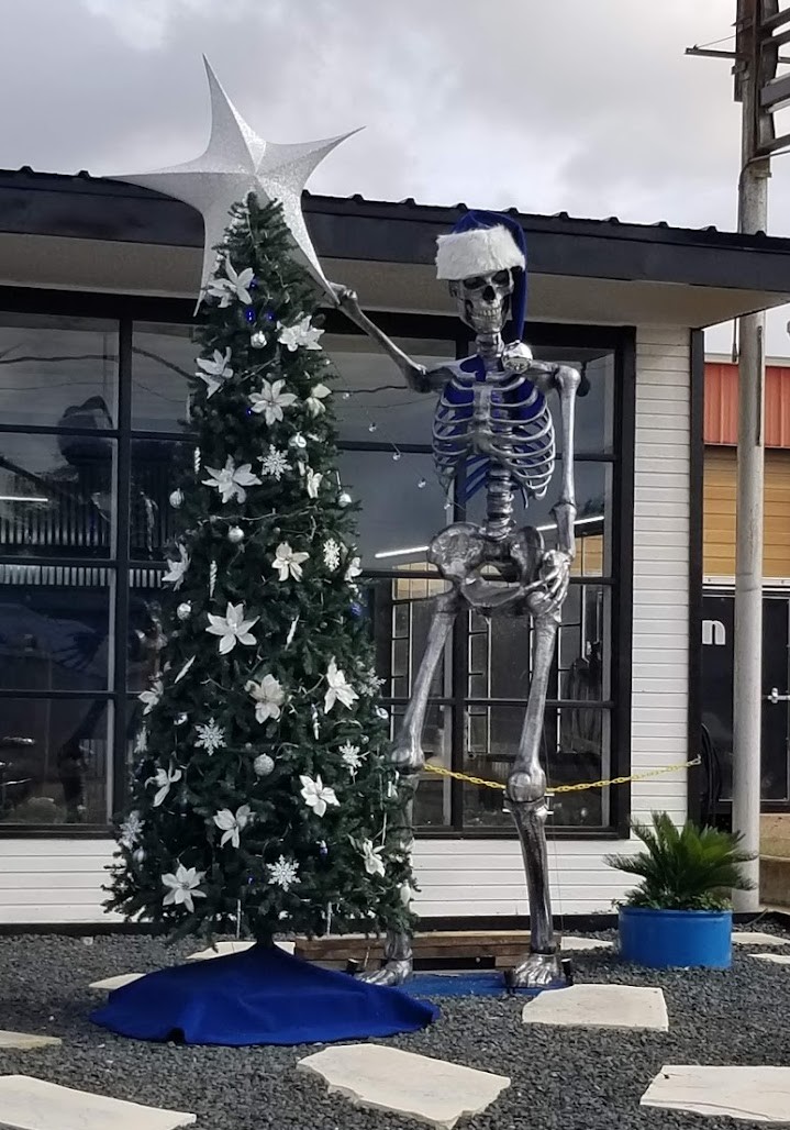
And then there's those unexpected crazy roadside things that make you do a u-turn and snap a quick photo! So here's this giant metal skeleton, probably left over from Halloween, now decorating a Christmas tree. The business is Fusion by Chris Vaughn. I checked out their website and he's a fabricator / designer of some really cool and unique home décor pieces.


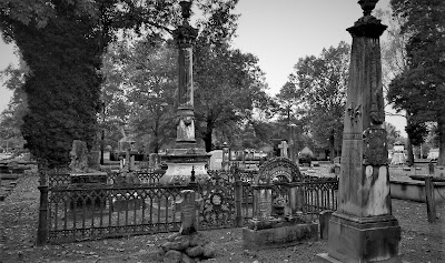
Arriving at the Kreische Brewery Monument Hill state historical sites in La Grange, Texas, we stop first at the Monument Hill Tomb as seen at the top of this page. Even after the Republic of Texas won its independence from Mexico, Texans continued to battle in skirmishes with Mexico in continuing border disputes.

Meeting at great oak tree in downtown La Grange, Captain Nicholas Dawson gathered a company of 54 volunteers to help as Texas fought Mexico in and around San Antonio. On September 18, 1842, Dawson and his men made their way to join other Texas forces at the battle of Salado Creek near San Antonio. Along the way they were intercepted by Mexican troops and fighting ensued. Later known as the Dawson massacre, the conflict leaving 36 Texans dead -- including Dawson. Their remains are entombed in a granite crypt on a bluff overlooking the town. (GC3XF1C)


To prevent other attacks, President Sam Houston ordered General Somervell to march about 750 men towards the border. Upon reaching the Rio Grande, the general stopped the men from going forward due to a shortage of supplies. However Colonel Fisher and a group of 300 men continued on down towards the Mexican city of Mier to look for supplies. Fighting started but Fisher's men were outnumbered and eventually surrendered. The remaining men were then marched to prisons in southern Mexico.

During the forced march, the captured Texans managed to escape into the mountains at Hacienda Salado. There, many died without food, water, and shelter. While five managed to returned to the Republic, the remaining 176 men were recaptured. It was decided that every 10th man would be executed. To determine this, each prisoner would draw a bean. If they drew a white bean they live. If they drew a black bean they die. After writing letters home, the condemned men were lined up, blindfolded, and executed as depicted in the mural below. Known as the Black Bean Episode, the event cost 17 men their lives.


To ensure that these men were properly honored and interred, the La Grange community selected this hill for their final resting place in 1848 in a sandstone vault. The Kreische family did its best to care for the grave during their ownership of the property, but it suffered from a lack of formal oversight. In 1905, the state authorized acquisition of .36 acres here and the Daughters of the Republic of Texas raised funds for a new cover for the tomb in 1933. During the 1936 Centennial celebration, the 48-foot shellstone shaft with a stylized art-deco influenced mural was erected to mark the mass grave more prominently.

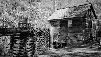
As for the Kreische family, German immigrant Heinrich Kreische (1821-1882) purchased nearly 175 acres of property in Fayette County in 1849. A stonemason by trade, he built a house, a barn, and smokehouse here on the high south bluff above the Colorado River.


In the 1860's, Kreische began brewing bluff beer near his homesite. Situated on the spring-fed creek, the brewery (GC1D2BQ) included an elaborate tunnel system to provide temperature control for the brewing process. Bluff Beer was sold throughout central Texas and was produced until 1884, two years after Kreische died in a work related accident. The Kreische complex stands as a reminder of German heritage and culture in this region of the state.


Our last stop of the day was a virtual geocache of European settlement history in Texas (GCGG9Q). The Wendish migration to Texas was impelled, in part, by the Prussian insistence that the Wends (or Sorbs, as they called themselves) speak and use the German language, even to the extent of Germanizing their names. The oppression of the Wendish minority extended to working conditions, with Wends being denied the right to do the skilled labor for which they were trained. If they were hired at all, they received less pay than their German counterparts. Prussian agrarian reform laws of 1832 dispossessed the Wends of their real property so they were, in effect, vassals to their Prussian lords.

But most intolerable was the requirement that the Lutheran Wends join the Evangelical Reform churches in one state-regulated Protestant body. The Wends believed this action would dilute their pure Lutheran faith and, rather than accept this decree, they made plans to immigrate to the New World.


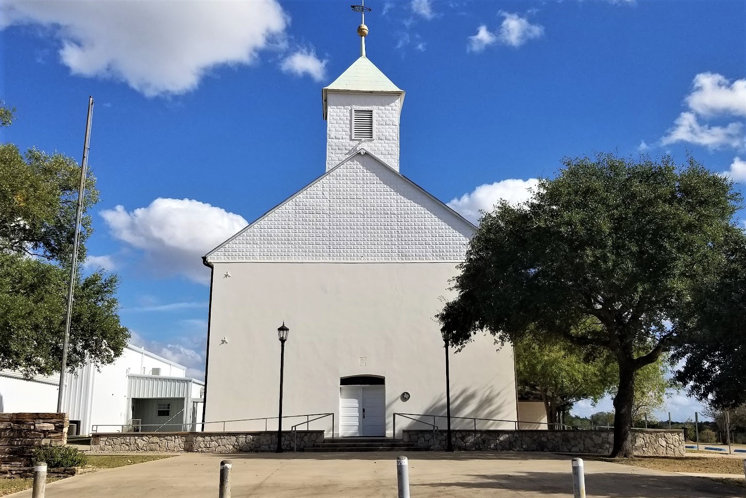
In December of 1854, an English sailing vessel, the Ben Nevis, docked in Galveston harbor loaded with some 500 immigrants from Lusatia, an area in eastern Germany comprising parts of Saxony and Prussia. These Slavic pioneers who were to settle in Lee County made the journey from their homeland, not in search of prosperity, but rather in search of religious liberty and the right to speak their Wendish tongue.

On the 150th anniversary of Serbin, Texas, this monument was erected by the church and cemetery. The historical marker states: "Dedicated to the loving memory of those lost during the 1854 Wendish migration from Germany to Serbin. From September 10, 1854, until the dedication of the church cemetery on March 17, 1855, eighty-three men, women, and children perished in route to this place. Most were buried at sea."


Well that was it for this little road trip through Texas history. Better than sitting in a classroom reading from a book, getting out and visiting the small rural towns along America's backroads is very interesting to me and hopefully to you too. Thank you for riding along.

To follow along on our travels and keep up with my latest blogs, you may do so here of course. But also by using your favorite of these social media platforms: FacebookMeWeGabRedditParlorTwitterRVillageGETTR and Instagram. These all link directly to my profile. Again, please feel free to comment and / or share.

Saturday, April 2, 2022

2020-10-19: Westbound Roadtrip Through Tennessee Civil War History and a Walking Tall Sheriff

Here we are on Day #2 of our westbound roadtrip. Today's trip took us from the Civil War history in Chattanooga through the backroads along the southern route of Tennessee towards Memphis. There's a lot of sightseeing to do, a lot of new geocaches to find, and new counties to add to my map. So climb aboard and let's go for a drive...


With its railroads and riverboats, the city of Chattanooga was a vital transportation center during the Civil War. Both armies recognized its importance. In the late summer and fall of 1863, several key military actions decided the fate of Chattanooga, and helped determine the fate of the Confederacy.

September 18-20: About 10 miles south of Chattanooga near West Chickamauga Creek, Confederate forces defeated the Union Army in a bloody two-day battle. The Federals withdrew to Chattanooga and fortified the city.


September 22 - November 23: Confederates laid siege to the city of Chattanooga to force the Federals to surrender. Confederates occupied positions along the Tennessee River, Missionary Ridge, and Lookout Mountain. In late October, the besieged and hungry Federals managed to open a supply line through Lookout Valley into the city. With fresh troops and supplies, they were ready to fight by late November. On November 23rd, Union troops stormed and captured Orchard Knob, a hill to the east of their defense line in the city.


November 24: Union forces drove the Confederates from their position on Lookout Mountain. Because the mountain was partially shrouded by fog, the action was also called the "Battle Above the Clouds." The following day, Union forces stormed and shattered Confederate unites occupying Missionary Ridge. The siege was broken and Chattanooga became the Federal base from which Maj General William T Sherman would launch his Atlanta campaign in the spring of 1864.


Point Park preserves strategic high ground captured by Union soldiers during the Battle of Lookout Mountain in 1863. Today it is part of Chickamauga and Chattanooga National Military Park and the location of our first virtual geocache (GC41C9). The New York Peace Monument, the centerpiece of the park, symbolizes the reconciliation of the North and South.


Driving down off Lookout Mountain, I made a stop near the base of the Incline Railway for our next virtual geocache (GCMFYC). The Incline Railway up historic Lookout Mountain is the world's steepest passenger railway. The first Incline up Lookout Mountain opened in 1887. It ran from the 38th Street area in St. Elmo to just below the Point. The second Incline, engineered by John Crass, opened November 16, 1895, and is the Incline that is still in operation today. The success of the second Incline was the primary reason that the first Incline closed in 1899.

The incline, 1,972 feet long and rising 1,450 feet, is superbly designed to suit its location. It makes use of a variable grade, ranging up to 72.7 percent near the top, to compensate for the changing weight of the cables as its cars move. One of the cars has flanges on the inside of its wheels, the other on the outside, allowing the cars to pass midway with no moving parts in the track turnouts. Both cars have self-contained emergency brakes. Originally powered by steam, the incline now is driven by two 100-horsepower motors. The latest evolution of the incline cars were just recently installed in March 2020.


Robert Craven built the first house on the hillside of Lookout Mountain in 1856. Seven years later, the Confederate Army occupied Lookout Mountain and Craven's house became the headquarters of Brig. Gen. Edward C. Walthall. On November 24, 1863, Union troops stormed the mountain and pushed the Confederates around to the north end.


When Robert Craven returned to his home after the battle, he found little of his home standing except the basement, the chimney, and the stone dairy. In addition to artillery damage, soldiers had stripped the house looking for souvenirs and firewood. The Cravens rebuilt the house as it currently stands.


Many of the Civil War Battlegrounds have monuments scattered throughout placed by the various states as a memorial to those soldiers who fought and died while representing their states. This particular memorial statue was honoring those soldiers from the state of New York. There is another monument nearby from Illinois which also happens to be a virtual geocache (GC621C).


Finally leaving Chattanooga and Lookout Mountain to continue our roadtrip westbound, we enter the town of Winchester in Franklin County. The town was named after James Winchester (1752 - 1826), who was a soldier in the American Revolution, Speaker of the First Tennessee Legislature, and Brigadier General in the War of 1812. The town of Winchester was created as the Franklin County seat on November 22, 1809.

One of the many monuments and historical markers located within the town square was this one dedicated to the memory of Colonel James Lewis (1756 - 1849). It is also another virtual geocache (GC9366). Col. Lewis served with distinction in the Revolutionary War. He participated in the battles of White Plains, Trenton, Princeton, Brandywine, Germantown, and Yorktown. He erected the first brick house in town and was one of the appointed commissioners for the erection of the first courthouse and jail in Franklin County. There are two other historical accomplishments, but that would give away the answer to the virtual geocache.


The one building that caught my eye the most was the Oldham Theater. Apothecary and druggist shops were originally on this corner from the 1820's thru 1900 with doctors offices upstairs during the 1880's. Later the street level housed the Franklin Grocery and Bakery until the 1930's. The spacious upstairs was hosted large civic gatherings and parties while leased by the Business and Professional Women's Club. The old building was razed in 1949 for construction of a theater.

George E. Oldham, who owned the Rivoli Theatre on the south side of the square, bought this theater from his brother-in-law in 1949 while it was still under construction on the north side of the square as a replacement for his older theater. Unfortunately, George Oldham passed away in September 1949 before the theater officially opened a year later on September 14, 1950 and named in his honor.

Though virtually unchanged in appearance, ownership changed several times and a major renovation began in 2009 and took three years to complete. The upgrade to the two-screen theater included incorporating digital projection equipment, installing surround sound, new curtains and new seats. I think it's pretty cool to see these old theaters still in use.


Continuing our drive west on US-64, the next Tennessee county needed for our geocaching map was Giles County. We stopped in the town of Pulaski at this unique and historical cemetery and memorial park (GC5BQW0). The first cemetery in Pulaski was on the outskirts (at that time) of town in 1817, in a field where interments continued until 1883 when all of the lots were full. Over the years abandoned and nearly forgotten, the cemetery fell into disrepair.

Until in 1969, Pulaski began an urban beautification project here to transform the old cemetery into a city park. The overgrowth was cleared out and headstones were located, identified and cleaned. The headstones were then mounted; the smaller ones in curved structures on the ground and the larger ones into a stone wall along the back of the park. A few monument markers that were still standing after the years were left where they were. Finally, landscaping, paved paths and lighting were added. The interred remains were left in their original locations as it could not be determined who was where except for the few monuments that were still standing.


Moving on into Lawrence County and the town of Lawrenceburg, we find our next two geocaches and a look back into Tennessee history. First was the Garner Mill Earthcache (GC1PPNT). The Garner Mill was used extensively from 1825 to 1849. It was built in 1820, and functioned as a grist mill initially, and then was converted to a water powered sawmill in 1851. Both the dam and the mill were destroyed in the flood of July 13, 1998. The ruins of the foundation still survived the flood, as well as the footings for the dam on the far side of the river. It is listed on the National Registry of Historic Places.


Closer to the center of town was our next geocache at the home of Davy Crockett (GC6K21P). David Crockett lived in this cabin from 1816 to 1822. He was one of the commissioners who laid out the county and selected the site of Lawrenceburg, a colonel in the militia, Justice of the Peace, member of the legislature, and operator of several industries on Shoal Creek during his residence here.


In the Lawrenceburg town square is a statue of Col. Davy Crockett. Born in East Tennessee on August 17, 1786, he gave his life for Texas Liberty and Independence at the Alamo that fateful Sunday morning on March 8, 1836.


Still heading westbound on US-64 picking up new geocaching counties, I make a quick roadside stop for a geocache in Wayne County (GC6B2WF). It was a good thing I stopped for the easy geocache because my target cache was a DNF (GC69K7B). But the good thing is that you never know what you're gonna see while geocaching. Like this homemade rocket ship trike!


Next up was Hardin County in the town of Savanna along the banks of the Tennessee River. There once was a house here built by James Rudd, a pioneer ferry operator, long before the US-64 highway was crossing the river. That house was replaced by another built by David Robinson, whose son-in-law William H. Cherry, improved and enlarged it. During the Civil War, "Cherry Mansion" became the headquarters for Federal Army commander Major General C. F. Smith. When he died he was succeeded by Major General Ulysses S. Grant. Maj. Gen. Wallace died here after being mortally wounded at Shilo.


Unfortunately the geocache had gone missing and I had to DNF it (GC2TVN9). Still needing the county, I stopped a couple blocks away at this small park memorializing the Battle of Shiloh where I found the geocache hidden here (GC1F8PZ).


Just a short drive over to McNair County, and we stop for our next geocache (GC5T5DM) highlighting a local hero and nationally known figure. The movie "Walking Tall" made Sheriff Buford Hayes Pusser a household name. He was born near Finger, Tennessee on December 12, 1937, raised here and graduated from Adamsville High School in 1956. About a year later, Buford moved to Chicago where he worked as a die cutter, attended Worsham College, and wrestled professionally on weekends. While in college he met and married Pauline Mullens.


The saga of Bufford Pusser and the illegal activities on the Tennessee-Mississippi state line began early in 1957, when he was beaten severely at a club in that area. In January 1960, he was arrested for assaulting the owner of a club on the Mississippi side of the3 state line. Bufford received a verdict of innocent at a trial held in Corinth, MS.

Buford's career in law enforcement began when he was appointed Chief-of-Police of Adamsville in 1962. He was later elected Constable and then Sheriff of McNairy County, serving three terms. During his first year as Sheriff, Buford was stabbed on several occasions and along with his deputies raided over forty-two moonshine operations. In 1966 he was forced to shoot in self-defense the operator of a motel on the state line where he had gone to investigate a robbery. In January of 1967, Buford was shot at point blank range four times by two men he had stopped in the state line area. The most deplorable episode in his career began one early morning on August 12, 1967 when he, accompanied by his wife, was enroute to answer a call. They were ambushed on New Hope Road, killing Pauline with Buford barely surviving the ordeal being severely wounded himself. In December 1968, Buford answered a call for help and a known murderer opened fire on him, leaving him no choice but to shoot and kill him in self-defense.


Sheriff Buford was selected in 1970, by the Jaycees, as one of Tennessee's "Outstanding Young Men of the Year." He had signed a movie contract to depict himself in a sequel to the movie "Walking Tall" when he was suddenly killed in an automobile accident on Highway 64, west of Adamsville, on August 24, 1974.

Bufford Pusser's experiences have inspired seven movies, five books, a television series, several magazine articles, and a Colt Commemorative Limited Edition handgun, all depicting the life of a man who "Walked Tall."


Our last geocaching county of the day is for Hardeman County and the town of Bolivar, Tennessee. It was a quick park and grab geocache to claim a find in the county (GC4WGKP).

From there it was just a couple of blocks south to the Polk Cemetery. Even though there's wasn't a geocache there, it was historical and worthy of a stop. The land was acquired by James K. Polk Jr. and others on October 23, 1845 as a family cemetery for the descendants of Ezekial Polk. Colonel Polk, the patriarch of the Polk family in Tennessee, was the grandfather of President James Knox Polk. The elder Polk was instrumental in framing the Mecklenburg Declaration of Independence and served in the Revolutionary War. He lived in Maury County before settling in Hardeman County.


That's all for today. We continue heading west on US-64 and find a place to stay for the night just outside of Memphis. I'm thinking a trip to Elvis's Graceland in the morning might be a plan. I hope you return to see the outcome. Until then...

To follow along on our travels and keep up with my latest blogs, you may do so here of course. But also by using you favorite of these social media platforms: FacebookMeWeGabRedditParlorTwitterRVillageGETTR and Instagram. These all link directly to my profile. Again, please feel free to comment and / or share.

Friday, February 18, 2022

2020-10-18: Westbound Roadtrip Through North Carolina and Tennessee

Westbound and down, eighteen wheels are rollin'.... OK, so there aren't 18-wheels. But our time in North Carolina has come to an end and I gotta week to start the next project in Guy, Texas. TIME FOR ANOTHER ROAD TRIP! Time for geocaching, sightseeing, and exploring more backroads and byways between here and there.

Today we drove all the way over to Chattanooga, Tennessee. We discovered an old mill, a waterfall, a giant Harley-Davidson, a copper mine, and a historic cemetery. So climb into the GeoJeep and let me show you...


Not to take up too much time starting out, I quickly drive up to I-40 and head westbound. The first few hours were nonstop all the way to Cherokee, NC and our first geocache (GCGYMA).

For 50 years, nearby farmers brought their corn and wheat to Mingus Mill, built in 1886. The miller usually charged a toll of one-eighth of the grain the customer brought for milling. The gristmill's stone was turned by a water-powered, cast-iron turbine. From water pressure built up in the penstock at the flume's end, the turbine generated 11 horsepower, enough to run all the mill's machinery. On the second floor, the smut machine blew wheat grain free of debris, while the bolting chest separated ground wheat into grades by sifting it through fine to coarse bolts of cloth.

Mingus was the largest gristmill in the Smokies. Its 200-foot-long wooden flume brings water to the mill's turbine. As early as the 1820's, more progressive millers began using turbines to power their mills rather than waterwheels. The Mingus family sold the mill to the National Park Service in the 1930's.


Continuing the scenic drive west on US-74, we headed for Juney Whank Falls and our next geocache (GCMBAZ). This puzzle cache requires gathering information along the 4.4 mile Deep Creek - Indian Creek loop trail. However once we arrived at the trailhead we weren't up for a long hike. So we just took the short hike to the first of several waterfalls for some photos.


Here's one of those reasons why I like driving the backroads and byways through rural towns and communities across this great country. Passing by Cherokee County Cycles, I spotted this HUGE Harley-Davidson custom motorcycle along with a couple of other cool vehicles in the parking lot. I just had to pull in and get a few pics!


Crossing over into Tennessee, we check out the Great Copper Basin Earthcache (GCNP87) and a new caching county of Polk County. In 1843, a prospector, hoping to find gold south of the Coker Creek mine fields, instead located one of America's richest copper reserves. Over the next century, American and foreign companies chartered more than a dozen copper mines in the Ducktown Basin. The last mines closed in 1987. Many of the buildings still remain today.


We ended our day in Chattanooga at the National Cemetery for two virtual geocaches (GC5148, GC4E66). On Dec. 25, 1863, Maj. Gen. George H. Thomas, “The Rock of Chickamauga," issued General Orders No. 296 creating a national cemetery in commemoration of the Battles of Chattanooga, Nov. 23-27, 1863. Gen. Thomas selected the cemetery site during the assault of his troops that carried Missionary Ridge and brought the campaign to an end. The site Thomas selected was approximately 75 acres of a round hill rising with a uniform slope to a height of 100 feet; it faced Missionary Ridge on one side and Lookout Mountain on the other. Gen. Grant established his headquarters on the summit of the hill during the early phase of the four-day battle for Lookout Mountain.


By 1870, more than 12,800 interments were complete: 8,685 known and 4,189 unknown. The dead included men who fell at the battles of Chickamauga, Missionary Ridge and Lookout Mountain. There were also a number of reinterments from the surrounding area, including Athens, Charleston and locations along the line of Gen. Sherman’s march to Atlanta. A large number of men—1,798 remains—who died at the Battle of Chickamauga were relegated to unknowns during the reinterment process. In addition to Civil War veterans, there are 78 German prisoners of war buried here.

The Andrews Raiders Monument, erected by the state of Ohio in 1890, is among the most unique memorials in the cemetery. The granite base and die is topped with a bronze replica of “The General,” the Civil War-era wood-burning locomotive famous for its great chase of 1862.


Today, the Chattanooga National Cemetery encompasses just over 120 acres and nearly 60,000 permanent residents.

After 300 miles of driving, it was time to call it a night. Tomorrow is another day with new adventures and things to see. I hope you have enjoyed today's journey and will return for many more...

To follow along on our travels and keep up with my latest blogs, you may do so here of course. But also by using you favorite of these social media platforms: FacebookMeWeGabRedditParlorTwitterRVillageGETTR and Instagram. These all link directly to my profile. Again, please feel free to comment and / or share.

Saturday, August 21, 2021

2019-12-24: Visiting the Iwo Jima Monument... in South Texas?

Hey everybody! Well this is a short and sweet blog post. I had some personal business to take care of way down in South Texas in a town called Harlingen, not too far from the southern tip near Mexico. I did want to highlight a couple of places here though. I bet you're probably wondering about this first photo though. Why are you using the Iwo Jima statue pic in a blog about south Texas? Because the original... well I'll get to that in a minute. We haven't left the hotel yet this morning!


So when making reservations on South Padre Island, the "ocean front" rooms were all booked. OK, so second best thing is the "ocean view" rooms. When we arrived last night it was already dark and couldn't tell the difference. This morning I look out and really? Ummm really? Where's the water? Maybe if it rained hard and the parking lot next door flooded! Oh well, just stayed the night anyway. Gotta take care of business and hit the road.


Down the block, I saw this gift shop and just had to pull in for a photo opp with the GeoJeep! Saw something similar in Myrtle Beach, SC and backed the Jeep up into the mouth. This place was open already so I decided not to.


After the quick personal business stop in Harlingen and breakfast at IHOP, we drove over to the Marine Military Academy near the Valley International Airport for two great geocaches. The first was a traditional cache hidden under a tank-like "Expeditionary Fighting Vehicle" (GCMT90). I was so focused on the main attraction, that I forgot to get a pic of it!

The Iwo Jima Monument located in Washington D.C. wasn't the original monument. On Feb 19, 1945, Marines invaded the island of Iwo Jima, a Japanese stronghold in the Pacific. Two days later, Marines reached the top of Mount Suribachi and a small American flag was raised. Later, on the same day, a larger flag was raised by six Marines. Associated Press photographer Joe Rosenthal captured that flag raising on film. A few days later it was published in Sunday papers across America. Sculptor Dr. Felix W. de Weldon, then on duty with the U.S. Navy, saw the photo and constructed a small scale model within 48 hours.


After the war, Dr. de Weldon worked for 9.5 years to create a full size model from molding plaster. The survivors of the flag raising posed for the artist to create their faces. Photos and physical descriptions of the three who gave their lives were used in modeling their faces.

Once completed in plaster, the statue was disassembled and shipped to Brooklyn, N.Y. to be cast in bronze. It took 3 years for the casting process. The bronze parts were then shipped to Washington D.C. for erection in Arlington National Cemetery. The plaster working model was shipped to Dr. de Weldon's studio in Newport, R.I. The U.S. Marine Corps War Memorial was dedicated on Nov. 10, 1954.


In October 1981, after much consideration, Dr. de Weldon gifted the original working plaster model to the Marine Military Academy in Harlingen, TX. This site selection included: 1. Fairly consistant temperature and humidity for preservation of the molding-plaster figures. 2. The street facing the memorial was named Iwo Jima Boulevard in 1965. 3. The MMA is the only place outside of Washington D.C., where proper honors are rendered with battalion-size dress blue parades. 4. The Marine placing the flagpole into the ground was a native of the area, Cpl Harlin H. Block. Block's gravesite resides directly behind the monument. Cpl Block was killed during continued fighting on Iwo Jima only a few days after the flag raising. .

The Iwo Jima Monument was dedicated April 16, 1982 on the MMA Parade Ground. It is coated with fiberglass for weather protection. And now it is also a virtual geocache 
 (GC7B6ED).

From there it was a long 6 hour drive back to Killeen, Texas so Candy can spend Christmas Eve and morning with her grandkids. Then later Christmas Day driving to McCamey in West Texas for work on Thursday. I'm exhausted! I need to go back to work to get some rest! See ya next time...

To follow along on our travels and keep up with my latest blogs, you may do so here of course. But also by using you favorite of these social media platforms: FacebookMeWeGabRedditParlorTwitter, and Instagram. These all link directly to my profile. Again, please feel free to comment and / or share.

Saturday, July 17, 2021

2019-07-20: My Roadtrip Finding Giant Spiders, Memorials, Cemeteries, and Sculptures in North Central Texas

Hello travelers, geocachers, and explorers. For today's edition of AwayWeGo's Geocaching Adventures, I got out of work early on this Saturday. That gave me some extra time to stop for a few geocaches on the way back to Killeen. Today we'll visit a couple of memorials, cemeteries, and some interesting sculptures. We have over 300 miles of driving and an open seat in the GeoJeep, so hop on in and let's go for a ride.


My first stop was a short drive down the road to the Knox County Veterans Memorial located in the town of Benjamin (GC19EFG). This impressive memorial is dedicated to all the citizens from Knox County who have made the ultimate sacrifice in service to this country throughout the various wars.


After the memorial, I drove over to the Benjamin Cemetery for another geocache (GC5N4H7). There are around 800 burials dating back to 1886. Benjamin is the county seat and first town organized in Knox County. Hilory H. Bedford, president and controlling stockholder in the Wichita and Brazos Stock Company, founded the town in 1885 and named it for his son Benjamin, who had been killed by lightning. The town received its first mail service in 1884; Bedford was postmaster. In 1886 the Benjamin school was organized with R. P. Dimmitt, Mrs. Oliver, and Mrs. M. S. Berry as first teachers. Other early residents included W. P. Lane, who opened a saddle shop in 1885, Tom Isbell, the first sheriff of Knox County, and Dr. G. H. Beavers.


Driving south on Highway 6, passing through the town of Rule, Texas, I then stopped for two quick roadside geocaches (GC49G9G, GC4ZWD8).

Next up was the Capron Cemetery (GC5N3CT). It is a small rural backroads cemetery between Sagerton and Stamford in Haskell County. There are less than 100 interments here dating back to 1908. After a couple hours of research, I couldn't find much in the way of history for a town or community of Capron. Just a few obituaries for this cemetery. However...


...there was one story I found repeated in multiple newspapers across the country in February 1934, that mentioned the town.
           HEADLINE: Stunt Flyer Killed When Plane Crashes
        "Clarence 'Tailspin' Steffins, 28, Capron, Texas aviator, was killed here late today when the monoplane he was flying in an air circus fell in a spin. The crash was witnessed by his wife and a large crowd of spectators. A wing of the plane fell upon a motor car parked near the flying field, but occupants of the machine were not injured."

Continuing south, I arrive in the town of Stamford, Texas. Established by the railroad in the 1890's, Stamford was named by a railroad executive after his hometown in Connecticut. There was much history to see here, but I only stopped at one small corner to find a geocache (GC4ZWAZ) and see some interesting sculpture.

This first photo is often referred to "Bed Henge." Encircled like Stone Henge, the use of truck beds being inspired by the Cadillac Ranch around a cross made of wheels created by artist and Mayor Johnny Anders.


Mayor Anders also constructed his variation of the VW Bug / Spider sculpture. In this one though he used the Italian made Isetta microcar.


And finally, the Centennial Monument was dedicated June 30, 2000 to commemorate the 100 year anniversary of Stamford. A tribute to the area's railroad and ranching history.


Moving along southbound, there were several quick roadside geocache stops before reaching my last geocache of the day at Burnt Branch Cemetery (GC1DY6N). Located several miles northwest of Cross Plains, it's another small rural backroads cemetery with less than 100 interments which dates back to 1893. I also couldn't find much history about the cemetery or the area. There was one headstone that caught my attention. Private Benjiman Clarence Barclay was just 22 years old when he died on November 1st, 1918, just 10 days before the end of World War I. Searching old newspapers though, I couldn't find any stories on Private Barclay. But I can only assume he died while in service.


That's it for today. Come back again tomorrow for the return drive and see what else we can find...