Showing posts with label museum. Show all posts

Saturday, May 21, 2022

2020-11-01: Visiting Some History, Geocaching and a Pirate on Galveston Island, Texas

After our first week in West Columbia, Texas, we had gotten settled in at the Plantation Oaks Resort RV Park. And we had a week at the new jobsite up in Guy, Texas to begin our next solar construction project. Today, however, was a fun day! We drove over to Galveston Island for some history, some geocaching, and to find a pirate. So who's up for an adventure? Let's go see what we can find!


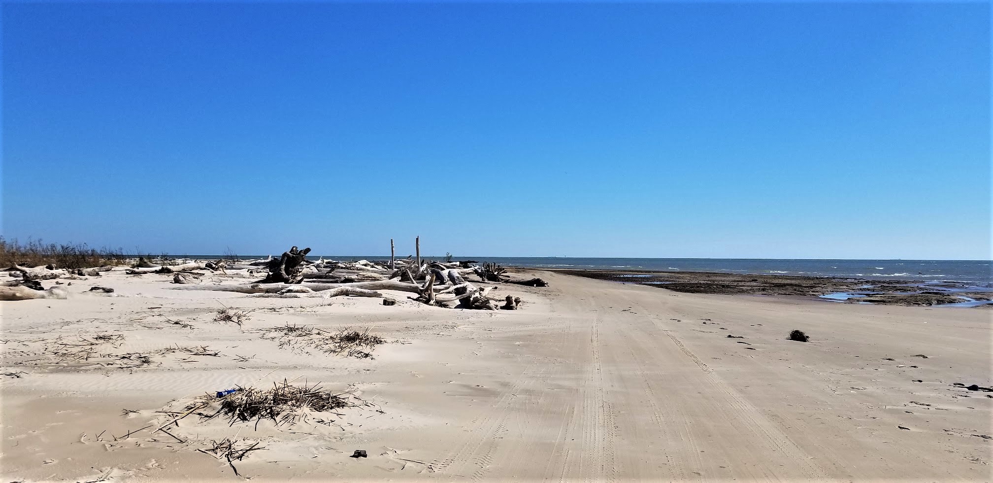
Our first stop down along the Gulf of Mexico coastline was in Freeport at the mouth of the Brazos River. There was a geocache there called Bryan Beach 4x4 (GCEA24). And when in the GeoJeep, it just calls out to go and find it! Well we did check out the beach but the geocache was nowhere to be found. First hidden way back it 2003 and I guess it frequently washed out to sea. It is now archived since the cache owner has gotten tired of replacing it.


We did spot something sticking up out of the water though. Looks to be a mast from a sailboat. I wonder what happened there. Hmmm, could be an interesting hiding spot for a geocache of the Difficulty 5 / Terrain 5 category!


From the northeast end of Galveston Island at the Fort San Jacinto Historic Point, you can see some of the many cargo ships that come and go through the port.


Also at the Fort San Jacinto Historical Point was our next geocache (GC8V700). There were a lot of muggles (non-cachers) walking by and huge rocks making for many hiding places. I didn't spend much time looking because of those things and ended up DNF'ing that one too.

This part of Galveston Island has had many forts since the early 1800's. Basic Spanish and French forts were established from 1816-1818. Those were replaced by small sand forts and batteries by the Republic of Texas from 1836 to 1844. After Texas statehood and the start of the Civil War, the Confederate Army built sandbag breastworks and an earthen battery named Fort Point in 1863. All traces of these early fortifications were destroyed by the strong winds and tides which regularly reshaped the sandy tip of the island.

A more substantial fortification called Fort San Jacinto was built here by the U.S. Army in 1897. After the fort was destroyed in the hurricane of 1900, the seawall was extended northward in 1921 to protect this area. The fort was rebuilt and new gun emplacements were added for the defense of Galveston during World War II. The fort was decommissioned in 1956 and only one concrete base of the 90-mm guns remains today.

Moving in a few blocks away from the coastline to find some of the historical buildings on Galveston Island, there's the Sacred Heart Church. The earliest Catholic services in the Galveston area were conducted in 1838. The Sacred Heart Church was established as the fourth church on the island in 1884. The original building was destroyed in 1900 Hurricane. This current building was constructed in 1903-04.


Next door to the church is the Bishop's Palace and a virtual geocache (GCH1CG). The Bishop's Palace matched the architecture of the original Sacred Heart Church which was swept away in the Great Storm. Construction lasted from 1886 to 1893 and was built as a private residence for Walter Gresham, a politician-turned-lobbyist during the mansion-building boom of the late-1800's. He had it made of Texas limestone accented with gray granite, pink granite, and red sandstone. This, combined with steel framing, helped it weather the Storm when so many thousands of other buildings were swept into the Gulf of Mexico.

In 1923 it was purchased by the Catholic Diocese of Galveston to become the official residence of the bishop. But only one ever lived there. Reverend Christopher Byrne stayed there until his death in 1950. In 1963, the Catholic Church opened it to the public, making it the first of the Galveston mansions to be turned into a museum.


The St Paul United Methodist Church was founded in the late 1860's and can trace it's history through two earlier Methodist congregations in Galveston. A second larger church building replaced the smaller first structure. This third and current sanctuary was constructed in 1902 to replace the previous which was also lost to the 1900 Hurricane.


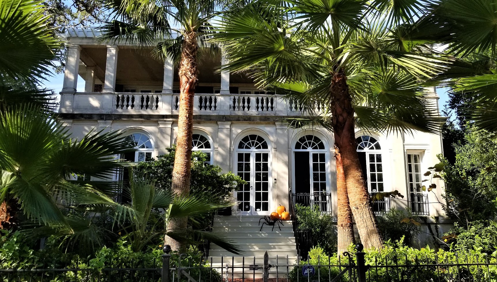
The Isaac H. and Henrietta Kempner House. Isaac Herbert Kempner, at age 21 and the eldest of Harris Kempner's eight children, took over his fathers many businesses after his death in 1894. Isaac became an important businessman in his own right and after the 1900 Hurricane demonstrated exceptional civic leadership in his efforts to rebuilt Galveston's entire infrastructure. From 1917 to 1919 he served as Galveston city mayor.

In 1904, the Kempner's purchased three lots and in 1906 their two-story neoclassical style home was completed. In 1924 additional lots became available and a concrete and stucco wing was added. The house remained in the Kempner family until 1970.


The Carl and Hilda Biehl House. Carl Christian Biehl immigrated from Germany in 1905 and founded a shipping company on Galveston. In 1915, Biehl purchased one of the damaged homes and cleared the site to build a new structure for his family. Designed by Anton F. Korn Jr and completed in 1916. The construction consisted of brick and concrete to stand up to the hurricanes and strong winds common to Galveston. The house remained in the Biehl family until 2008.


The William and Adele Skinner House. In 1895, local banker William Skinner and his wife Adele bought this parcel for a home for their young family. The two-story Queen Anne style house was completed in 1896 and remains as one of the more ornate residential designs. This structure was one of the few survivors of the 1900 Hurricane.


This next house didn't have a historical marker and I couldn't find any history other than it was built in 1965. But it does fit in well with the other homes.


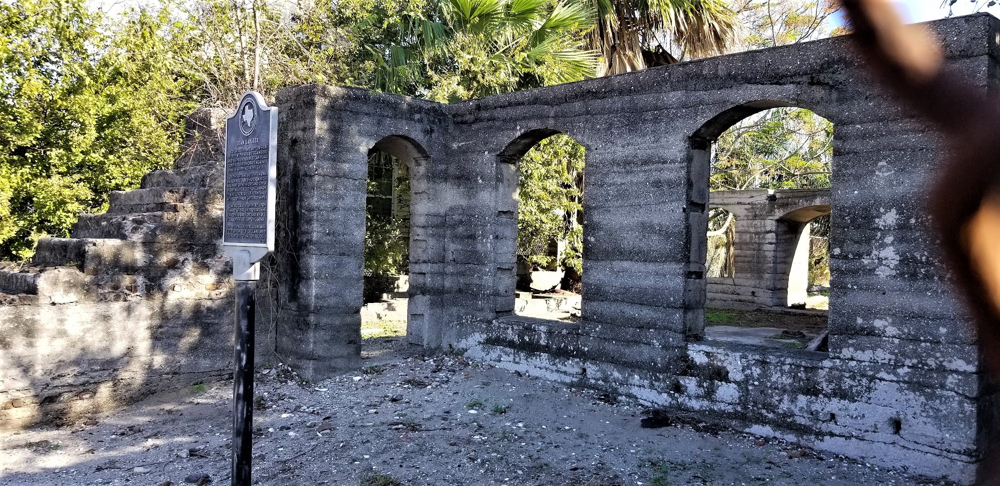
The last house I want to share with you is of the notorious pirate Jean Lafitte who settled here in 1817 with his buccaneers and ships, under Mexican flags, continued his assault against Spanish shipping in the Gulf.

Here he built his home, Maison Rouge (Red House), which was part of his fort, and upper story was pierced for cannon. It was luxuriously furnished with booty from captured ships. Leaving Galveston in 1821, upon demand of the United States, he burned his home, fort, and whole village, then sailed to Yucatan.

The walls that remain were built in 1870 over the old cellars and foundations of Maison Rouge. I'm curious as to what remains below the foundations and in the cellar. It would be cool to go down there and have a look around. This is also a virtual geocache.


That was it for our quick little return trip to Galveston Island. We visited here a few years ago in November of 2015 when it was a winter ghost town and most everything was closed.

Back on the mainland and headed to the RV Park in West Columbia, we made a short detour for another historical virtual geocache (GC2E13) in the town of Hitchcock, Texas. In an effort to defend U. S. coasts and shipping lanes against German submarine activity during World War II, the U. S. Navy established bases to house huge lighter-than-air (LTA) craft, also known as blimps were uniquely qualified for coastal defense and observation.

Because of its site on the flat Texas coastal plain, Hitchcock was chosen as the location for one of the nine new blimp bases. Construction began in 1942, and the facility was commissioned on May 22, 1943. The resulting military personnel build-up caused an economic boom in the community.

The Hitchcock base consisted of forty-seven buildings, including a massive hangar to house six blimps, administration buildings, warehouses, living quarters, and recreational facilities. Aircraft from the base, in addition to their regular patrolling duties, were also used to assist with hurricane relief efforts and war bond drives.

In 1944, after the blimps were no longer needed, the Hitchcock base was redesignated for other purposes. Following the war some of the buildings were used by private interests, and after hurricane damage in 1961 the blimp hangar was razed. All that remain are the towering hanger door supports.


Thanks for riding along today. Remember if you happen to find yourself on Galveston Island, there's more to see than the boardwalk on the beach.

To follow along on our travels and keep up with my latest blogs, you may do so here of course. But also by using your favorite of these social media platforms: FacebookMeWeGabRedditParlorTwitterRVillageGETTR and Instagram. These all link directly to my profile. Again, please feel free to comment and / or share.

Saturday, April 30, 2022

2020-10-20: Forget Graceland, We're Going to the Grotto! From Memphis and Geocaching Across Arkansas Counties

Welcome back everyone. This was Day #3 of our roadtrip from North Carolina to Texas. Last night we ended the day just outside and east of Memphis, Tennessee. And what is the first thing you do in Memphis? Forget Graceland. We going to The Grotto!! Not widely known but something that you must see if you're ever in the area. But until then, come with us for a virtual tour of this nearly 100 year old creation.


The plan was to start the day visiting Elvis's Graceland. But when we arrived at the entrance there were signs everywhere about masks being required. While I've been here before, Candy has not. Plus neither one of us are Elvis fanatics. It's just one of those places that you at least have to visit once in your life. However we just weren't up for touring this house during a "pandemic" wearing these silly masks. Which was a good thing because "Plan B" turned out to be a much better choice!


The Crystal Shrine Grotto is located in the Memphis Memorial Park and is also the coolest cemetery cache I've ever found! (GC9CBBIn 1924, E. Clovis Hinds purchased 160 acres of land on the outskirts of Memphis and transformed it into a tranquil graveyard he would call Memorial Park. A cemetery brochure describes his dream: “He sought not merely a pleasant, peaceful place of repose but an atmosphere steeped in tradition, linking the ancient past with the eternal future.”


Dionicio Rodriguez was born outside Mexico City in 1890 and immigrated to the United States in the early 1920's. He perfected a technique for chemically tinting concrete and then carving or molding it into naturalistic forms that closely resembled stones, logs, tree branches, down to such details as artificial worm holes, cracks in the wood, and peeling bark.  Rodriguez met Hinds here in 1925 and under Clovis’ guidance began the construction of what many would consider his masterpiece — the Crystal Shrine Grotto.


Words and pictures don’t really do it justice; only a personal visit shows the full scope of this endeavor. Using tons of tinted concrete, Rodriguez recreated scenes from the Bible and ancient literature. The Cave of Machpelah overlooks the scenic Pool of Hebron. Nearby are Abraham’s Oak, the Ferdinand IV Sunken Garden, Annie’s Wishing Chair, the Fountain of Youth, and other works — all made of cement. Perhaps the most unusual feature is the Grotto itself, a large manmade cavern carved into a hillside, with the high ceiling studded with thousands of quartz crystals. Inside, visitors can stroll past 10 panels depicting scenes from the life of Christ, which have been enhanced in more recent years by wood figures sculpted by Memphis artist David Day.


How did he carve out this grotto, or form these remarkable things, entirely alone? No one today is quite sure. Few photographs exist showing Rodriguez at work, because he was so secretive about his techniques that he often shrouded his projects in canvas until they were finished. After working at Memorial Park for several years, he left for other projects in other cities. He died in 1955 and is buried in San Antonio, but his remarkable creations live on. That’s because Dionicio Rodriguez took the time to make sure they were built to last. A marker at the Grotto explains that his artwork was “reinforced with steel and copper bar so as to ensure its existence for many centuries to come.”


Looking at some of the gravesites in the cemetery next to The Grotto, we noriced these two musical celebrities. The first headstone shaped, like a park bench, belonged to Marshall Grant (1928 - 2011). Buried there with his wife, he was the bass player for Johnny Cash and the Tennessee Two.


And not too far away from him was the legendary Isaac Hayes (1948 - 2008). A singer, songwriter, actor, composer, and producer, he was most known for the song "Soul Man" and the theme from the movie "Shaft."


We didn't spend much time looking throughout the remainder of the cemetery. There were probably many more graves of interest considering that there are almost 80,000 people laid to rest here. But we got to keep moving...

Crossing the Mighty Mississippi River over into Arkansas, we drove south of Interstate 40 into Lee County. A quick parking lot LPC geocache (GC1GE11) was requirement enough to fill in that caching county map.

Driving south into Phillips County, we found our next geocaching stop and more musical history (GC7KM9T). The son of an Arkansas Farmer, Levon Mark Helm was born May 26,1940, In Elaine Arkansas. He died April 19, 2012 in New York city. Lavon grew up listening to the music of the Arkansas Delta region west of the Mississippi River and Radio from Memphis, Nashville, and the King Biscuit Flower hour show from near by Helena Arkansas.

Helm started up his first rock group, The Jungle Bush Beaters, while in high school. In 1957, he joined Ronnie Hawkin's band as drummer. The group ended up in Canada where new musicians signed on. Levon and his fellow backing musicians split off from Hawkins, becoming Levon and the Hawks and then the Hawks. In 1967, he rejoined his bandmates in West Saugerties, New York. The group started calling themselves "The Band" and began to create and record their own songs. 

The house where Levon grew up, was moved from it's original location, Turkey Scratch five miles north, to its current location in Marvell.


Passing through Monroe County because I already had it, we arrived in Arkansas County. Just south of the town of DeWitt was a cemetery geocache (GC2C14A). I found the cache quickly and took a quick look around. Nothing really caught my attention and I didn't want to spend too much time there. Gotta keep putting the miles behind us.

Moving right along into Desha County, Arkansas, outside the town of Dumas, was a pioneer village and museum (GC3EYQ4). This collection of old buildings from around the area give you an example of what life was like for those seeking a new opportunity on the western frontier. Like this restored pre-1850 log home with the open breezeway in between two rooms to help with ventilation.


Or how about this old country church...


Not exactly luxury, but after working a long hard day on the farm or ranch, even the most meager thin beds would be welcome rest. Most bedrooms were multi-purpose rooms for sitting, reading, or even spinning wool or cotton into yarn or thread.


The next county over was Lincoln County and another quick cemetery geocache (GC1NY24). On the west side of Star City, Arkansas was the Leek-Drake Cemetery. With over 1500 permanent residents here and a lack of time, it was a short find the cache visit and a quick glance around. Nothing jumped out to peak my interest further, so down the road we went.

The same thing happened again in Cleveland County in the town of Rison. The Rison Cemetery geocache (GC1YE4B) was a quick find, a glance around, and move on down the road.

Now usually on my road trips, I have the targeted geocaches planned out so that I can get the needed counties to fill in the blank spaces on my geocaching map. And on occasion there's the unexpected sites that make traveling the back roads worth while too.

Passing through Kingsland, Arkansas, also in Cleveland County, we see the "Welcome to Kingsland" sign with the added "Birthplace of Johnny Cash." Well I'm not a country music fan but I do know who Johnny Cash is. And I've got some friends who are fans, one of which named his two dogs Johnny & Cash. So after a quick Google search we find the location and drive to the neighborhood. The house is gone and is now a community park. There's a church next door too. Along the street is this simple memorial. I kinda expected it to be in better condition than it was and was a little disappointed. But we can say now that we stopped at the "Birthplace of Johnny Cash."


Stopping in the town of Fordyce for a geocache in Dallas County, we come to the First Presbyterian Church (GC7WCDF). The church was first organized in 1883. As the congregation grew, this was their third building and was erected on this site in 1912. Now on the National Register of Historic Places, funds are being raised to restore this old church building.


Continuing our drive westbound, US-79 cuts through the northwest corner of Calhoun County. And finding a quick roadside geocache (GC8FZ1A) at the Welcome to Thornton sign filled in another empty spot needed on our geocaching counties map.

Crossing into Quachita County, the geocache in the Salem Cemetery (GC8TN20) gave us credit for that county. There are almost 2000 interments here in Salem, but no time to look around as it is getting late in the day, dinner time, and we're both hungry.


Our final geocache for the day was at the St. Matthew Cemetery (GC37P88) in Columbia County. About 400 interments, this cemetery dates back to 1867 and still serves the community.


Well we still have not yet made it to Texas. I'm sure we've all heard of "football time." Like the "two-minute warning" actually takes 10-15 minutes of real time. Or when a woman says they'll be "ready in a minute" when getting dressed up for a night out, turns into an hour later. 

Well the same goes for geocachers and road trips. According to Google maps, we should have crossed the Texas state line in about 5 1/2 hours from our start this morning. Here we are 10 hours later and still in southwest Arkansas. But we got to see a lot and had fun too. I mean what's the point of traveling for work if you don't get to enjoy the trip?

Time to finally get some dinner and find a place to stay for the night. We got one more Arkansas county to get to in the morning. Then finally back in Texas. I hope you enjoyed the ride. Post a comment to let me know you were here and feel free to share our blog with your friends. See you again real soon.

To follow along on our travels and keep up with my latest blogs, you may do so here of course. But also by using your favorite of these social media platforms: FacebookMeWeGabRedditParlorTwitterRVillageGETTR and Instagram. These all link directly to my profile. Again, please feel free to comment and / or share.

Saturday, October 2, 2021

2020-03-30: Roadtrip Day 4: Driving Through Alabama and Arriving in Georgia

Today was the fourth and final day of our Texas to Georgia roadtrip. This has been a great drive so far on the backroads and byways, seeing the sites, geocaching and picking up new counties along the way. For today we found some Civil War history, old cemeteries, a bird-dog champion and more. But I'm getting ahead of myself. Hop on in the GeoJeep and let's get rolling... 


Leaving out of Montgomery, Alabama, our first stop was southeast of town for a geocache at the Carter Hill Cemetery (GC2VFET). With just over 300 interments, the Carter Hill Cemetery dates back to 1844 with the burial of Andrew Allen. Along with his wife and two sons, they are the first four burials in this cemetery.

And then one more quick roadside geocache (GC2R7Y8) before leaving the county.

Continuing eastbound into Bullock County, we arrive in Union Springs and the Bird Dog Field Trial Capital of the World (GC56NF0). On February 21, 1996, the City of Union Springs and the Tourism Council of Bullock county dedicated this life-size bronze statue of an English Pointer. Sculpted by Bob Wehle, the monument pays tribute to the 11 men honored by the Bird Dog Field Trial Hall of Fame, to Bullock County’s unexcelled upland game country and bird dogs, and to the men and women who participate in the sport of field trialing.


Also located in Union Springs was this Log Cabin Museum. From the historical marker: "Early settlers of this area cleared land and built their first homes of logs in the 1830's. This cabin was built by Rueben Rice Kirkland (1829 - 1915) about 1850. He and his first wife had ten children while living in the log home.

"At one time an additional bedroom and chimney were on the right side, and the back porch was closed in for cooking and eating. A small log kitchen stood a few feet from the back and was later converted to a smoke house. The milk house beside the well was on stilts to protect butter and milk from animals.

"In 1981 the Bullock County Historical Society moved the cabin into Union Springs from its original site at Stills Cross Roads in Southern Bullock County and restored it as a museum."


If you look at the very first photo at the top of the blog, you can see that this new location of the cabin is off to the side of the Old City Cemetery, also known as The Confederate Cemetery. The historical marker reads: "Micajah Norfleet Eley donated land in 1849 for the Baptist Church and an adjoining public cemetery. The oldest cemetery in Union Springs, it served the city for 36 years. The Confederate Monument at the center (seen in the top photo) was unveiled at the intersection of Prairie and Hardaway Streets on March 29, 1895 by the Ladies Memorial Association. In 1973 it was moved to its present location.


"Locally known as the Confederate Cemetery, it includes the tombstones of some twenty-two Confederate soldiers. Below the Confederate soldiers' grave sites is a marker which reads: "Union Prisoners of War, 1861-1865, Victims of Plague."


US-82 eastbound over into Barbour County, the next geocache (GC2MY21) was a quick roadside stop at another historical marker. There wasn't anything to see there. Just the historical marker for the Election Riot of 1874 which read: "Near here is Old Spring Hill, the site of one of the polling places for the November 3, 1874 local, state, and national elections. Elias M. Keils, scalawag and judge of the city court of Eufaula, was United States supervisor at the Spring Hill ballot box. William, his 16-year-old son, was with him. After the polls closed, a mob broke into the building, extinguished the lights, destroyed the poll box and began shooting. During the riot, Willie Keils was mortally wounded. The resulting congressional investigation received national attention. This bloody episode marked the end of Republican domination in Barbour County."

Crossing the state line into Quitman County, Georgia, I quickly exit the bridge and turn back towards the reservoir for my next geocache (GC8M6AW). To the right just outside the photo below is the US-82 bridge which crosses over the lake. This little path heading down to the water is what remains of the old road that you used to drive between Alabama and Georgia before the Walter F. George Lock and Dam was built in 1962. Now it sits underwater.


Our last two geocaches were in Randolph County. The first was a quick roadside park and grab just east of the town of Cuthbert (GC7EV1G). The second was in the town of Shellman, Georgia (GC887JW). Originally called Ward Station, Shellman was established in 1883 and named after Major W. F. Shellman, who was the traffic manager for the Central Georgia Railroad. This was the Shellman Railroad Depot.


There's also these muraled silos in Shellman that portray the history and scenes of Shellman's past.


The next county over is Terrell and that's where we'll be staying and working. Time to settle in and relax after a long road trip. I hope you have enjoyed these last four days traveling along the rural backroads and byways of this great country of ours. And if I have inspired you to get off the Interstates and onto the scenic roadways, leave me a comment and let me know.

To follow along on our travels and keep up with my latest blogs, you may do so here of course. But also by using you favorite of these social media platforms: FacebookMeWeGabRedditParlorTwitter, and Instagram. These all link directly to my profile. Again, please feel free to comment and / or share.

Saturday, September 18, 2021

2020-03-28: Roadtrip Day 2: Driving Through Louisiana and into Mississippi on the way to Georgia

One thing I like about driving the backroads and byways on a roadtrip is that you never know what you're gonna see around the next corner. Whether it be a scenic overlook, a piece of history, or just something so crazy funny that it requires you to turn around for another look and capture it with a photo. Todays drive had something for everyone. So there's a lot to see now let's get rolling...


After waking up early in Shreveport, Louisiana and going for breakfast, I grabbed a quick urban geocache that was close by (GC7G3XD).

On the way to my next geocache, I passed this old church building. The sign out front said Antioch Baptist Church. It doesn't look like this facility has been used in many years. In preparing to write this blog post, I spent a few hours trying to research some history but kept coming up empty. I can't find anything on this old church.


So I arrive at the next geocache (GC1XVN5) which was just a simple and quick roadside cache to add a new county into the finds list. Upon arriving though and seeing the sign, I guess they take their "No Trespassing" pretty serious! I found the cache quick and got myself outta there!


After another quick roadside geocache (GC7QJ0X), I passed by these two old abandoned houses that were just slowly decaying and falling apart. I'm always curious as to what happened with these homes...


...especially this second house. It looked like it would have been a house to envy back in the day. Come to find out that it is called the Garland House. It was built in 1902 and placed on the National Register in 1994. It is a Queen Anne Revival design. This one is in great need of reviving.


Continuing eastbound on Hwy 2, the next geocache was at the Corney Creek Calaboose (GC26WWQ). A calaboose is a tiny jail. This calaboose in the town of Bernice, LA was built in 1902. The town of Bernice was established in 1899 as a sawmill town after Captain C.C. Henderson built the Arkansas Southern Railroad.


This next stop was rather sad. On the north side of Bernice is the old Mount Olive Cemetery (GC26HGV). This neglected forgotten cemetery contains between 40-50 burials dating as far back as 1860. However, I only saw less than 10 headstones in all this overgrowth. Some of the locals need to come out here and clean this cemetery up.


Still following State Highway 2 eastbound to pickup caches in these northern parishes, my next stop is an earthcache and a traditional cache at Elgin Springs (GC20PEP, GCJ4CV). It would have been a quick roadside stop, but I had trouble finding the traditional cache and had to DNF it. As for the earthcache, I got what I needed to answer the questions to log a find. No photos here since it really isn't much to see here. Not exactly what you picture in your mind when you think of natural springs.

To make up for the lack of photos at the springs, I was able to capture two great old car pics as an unexpected surprise. This one below of a 1920's sedan just rusting away among the trees along the highway. And the more humorous one I opened with at the top of the page.


These next two were just quick roadside park and grabs (GC73X26, GC23FEX).

Our next stop was a really cool piece of history in Oak Grove, LA. The Fiske Theatre (GC29ZM9) was first opened in April 1928 and at that time was the premier state of the art movie cinemas in Northeast Louisiana. It was owned and operated by the late Donald Fiske of Oak Grove. The Fiske Theatre was a two level cinema with a first floor that seated 500 people and a balcony that seats 250, as well as a cry room located on the back of the first floor for mothers with small children.

The Fiske Theatre was rebuilt in 1950 and relocated from just down main street to it's current location, and was operated continuously by the Fiske Family until 1987 as a first run cinema. It looks just about the same now as it did in the 1950's. In 1987 as Mr. Fiske's health began to fail him, the theatre was donated to the West Carroll Chamber of Commerce where it has been used mainly for gospel music concerts and other community events since then.


The theatre is in very good condition thanks to the hard work of the chamber volunteers and numerous grants for upkeep from the Louisiana State Legislature. After a two-month renovation period in the fall of 2008, the Fiske Theatre returned as a first run movie theatre on December 15, 2008 with a showing of "Fireproof". The theater is run by volunteers who share a passion for the preservation of this historic movie theater. Any proceeds go to the upkeep of this terrific piece of Americana. At the time of our visit to the Fiske Theatre was closed as the pandemic was just beginning to spread.

Next up was a geocache at the Cotton Museum (GC1CN8D). The Louisiana State Cotton Museum in Lake Providence provides a great introduction to one of Louisiana’s major agricultural crops, and certainly the one for which the Delta area is best known. Its main gallery features an extensive set of interpretive exhibits, including life-sized dioramas, farming equipment, a re-created juke joint and more, all packed into a replica gin house (where cotton fiber was ginned, or separated from the seed).


Also on the grounds of the museum is an impressive array of old plantation buildings, such as a sharecropper’s cabin, a schoolhouse, and a small chapel. And of course an old outhouse where the cache was hidden inside the business deposit area.


One more quick roadside geocache in the town of Transylvania (GC1CN8Z) along with the above museum are two caches for the East Carroll Parish completing the northern counties in Louisiana.


Now we face the Mississippi River and need to cross over. Most would go south to I-20 and cross over into Vicksburg. Been there, done that, and already have those counties. So I turn north into Arkansas. I stop for two quick geocaches along US-65 for Chicot County (GC2QTFTGC2R0NT). Then took US-278 to cross the great river.

Passing through Greenville, Mississippi, I spotted this riverboat and stopped for a quick photo.


The next few stops were part of the Mississippi Blues Trail. In the small town of Holly Ridge you'll find the final resting place of three bluesmen (GC15CJ1). Charley Patton (1891 - 1934) was the most influencing figure in the pioneering era of the Delta Blues. He helped define not only the musical genre but also the image and lifestyle of the rambling Mississippi bluesman. He roamed the Delta using Dockery as his most recent base, and lived his final year in Holly Ridge. Patton and blues singers Willie James Foster (1921 - 2000) and Asie Payton (1937 - 1997) are buried in the Holly Ridge Cemetery.

In the next town of Indianola, MS, I found the B.B. King Corner (GC4MZKG). It was on this corner, when Riley B. King was just a young man of 17, that locals first heard the musician destined to become the "King of the Blues." On June 6, 1980, BB King placed his handprints and signature here in the sidewalk to the left of the guitar.


Our last geocache of the day was at the Indianola City Cemetery (GC30XD5). This is a large well maintained cemetery with over 3,000 interments.


We ended the day in Greenwood, MS, a little more than 300 miles after we started. I picked up some new counties and parishes to fill the map. And we saw a lot of great roadside attractions, planned and a few surprises too. Tomorrow is another day and we still have a long way to go and a lot to see. I hope you come back and join us. See ya next time...

To follow along on our travels and keep up with my latest blogs, you may do so here of course. But also by using you favorite of these social media platforms: FacebookMeWeGabRedditParlorTwitter, and Instagram. These all link directly to my profile. Again, please feel free to comment and / or share.