Showing posts with label North Carolina. Show all posts

Saturday, January 1, 2022

2020-06-20: Taking a Trip Back to Mayberry and Andy Griffith's Hometown of Mount Airy, North Carolina

Welcome back friends, family, fellow traveler's, Geocachers, Jeepers, RV'ers, and ALL of you who've stopped by our AwayWeGo's Geocaching Adventures Blog. We're a couple of work travelers in construction and our job takes us all over the country. Currently, we're on a project in Central North Carolina near the town of Maiden.

Today was a great day to take a roadtrip back to Mayberry (GCJF95). Many say that "The Andy Griffith Show" was based on Mount Airy, NC, Andy's birthplace. So let's go for a drive and see what they've done to the town.

Mount Airy was settled in the 1750s as a stagecoach stop on the road between Winston-Salem, North Carolina and Galax, Virginia. It was named for a nearby plantation. Mount Airy was incorporated in 1885. The City's official seal was established in 1977, which depicts major industries that are home to Mount Airy including: furniture, textiles, and the granite quarry. In 1994, Mount Airy was named an All American City.


The Andy Griffith Show aired eight seasons on CBS from October 3, 1960, to April 1, 1968. The series originated partly from a prior episode of The Danny Thomas Show. The show stars Andy Griffith as Andy Taylor, the widowed sheriff of Mayberry, North Carolina, a fictional community loosely based on Mount Airy. Other major characters include Andy's cousin, the well-meaning and enthusiastic deputy, Barney Fife; Andy's aunt and housekeeper, Bee Taylor; and Andy's young son, Opie. Griffith said that the show evoked nostalgia, saying though it was shot in the '60s, it had a feeling of the '30s. It was, when we were doing it, of a time gone by."


Griffith was born on June 1, 1926, in Mount Airy, North Carolina, the only child of Carl Lee Griffith and his wife, Geneva. As a baby, Griffith lived with relatives until his parents could afford to buy a home. With neither a crib nor a bed, he slept in dresser drawers for several months. In 1929, when Griffith was three, his father began working as a helper or carpenter and purchased the home pictured below in Mount Airy's "blue-collar" south side. Griffith grew up listening to music. By the time he entered school, he was well aware that he was from what many considered the "wrong side of the tracks". He was a shy student, but once he found a way to make his peers laugh, he began to come out of his shell and come into his own.


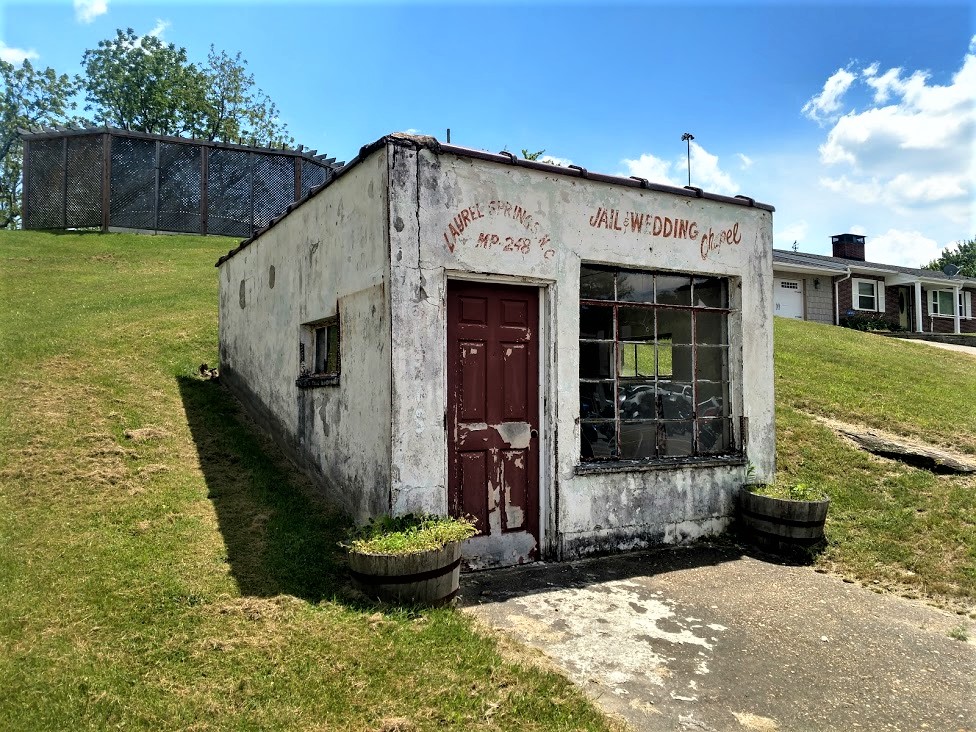
The Mayberry Courthouse is a replica of the courthouse that appeared in “The Andy Griffith Show” during the 1960s. Situated adjacent to Wally’s Service Station, visitors can sit behind Andy’s desk, type on the vintage typewriter, and even sit in the recreated jail cells that appeared in the show.


Remember Sheriff Taylor’s police car? The one you saw in every episode? In Mount Airy, you can tour all of the sites in a Mayberry squad car. Each tour starts at Wally’s Service Station, then it will travel up and down the streets of Mount Airy. Wally’s Service Station is an original service station built in 1937 and operated as a Gulf Station and then later operated as a Standard Oil Station or Esso.


As a student at Mayberry Union High (Mount Airy High School), Griffith cultivated an interest in the arts, and he participated in the school's drama program. A growing love of music, particularly swing, would change his life. Griffith was raised Baptist and looked up to Ed Mickey, a minister at Grace Moravian Church, who led the brass band and taught him to sing and play the trombone. Mickey nurtured Griffith's talent throughout high school until graduation in 1944.


The Darlings (usually pronounced "Darlin's") lived in a mountain shack, like the one below behind Wally's Garage, somewhere in the mountains neighboring Mayberry. The good-natured, but trouble-making Appalachian clan, led by patriarch Briscoe Darling (played by Denver Pyle) usually came into town piled into the back of their old truck.


Though Methodists had been present in Surry County since the 18th century along with Baptists, Moravians, Quakers, and other religious groups, the original Methodist church in town was established only in 1831. The “Old Methodist” cemetery belonged to Mount Airy’s Methodist Episcopal Church, South, after part of the 1831 Lebanon congregation moved to a new location on South Main Street in 1858. The cemetery and church were built on land donated from Elisha Banner’s plantation, and the earliest burial dates back to 1857.


Local tradition says that the church’s bell, now housed in Trinity Episcopal’s belfry, tolled during funerals for every year of the deceased’s life. The cemetery acted as a town cemetery, not just for one for Methodists, and it was replaced by Oakdale Cemetery in 1892 when space began to run out. The church changed its name to Central United Methodist Church when it moved closer to the center of town in the 1890s, and the last burials at the Old Methodist Cemetery (GC4NZNT) were made around the turn of the century.


Leaving Mayberry, we drove down the highway on the way back but not before hiking Mount Pilot. Pilot Mountain was the inspiration for the fictional town of Mount Pilot in “The Andy Griffith Show.” Nearby the actual town is Pilot Mount State Park (GC88Z1Y) which is known for its Big Pinnacle peak seen for several miles. It was a nice short hike over to the observation deck where I got this great wide angle photo.


That was our return to Mayberry. It's one of those must visit towns if you're a fan of the of the TV show.

To follow along on our travels and keep up with my latest blogs, you may do so here of course. But also by using you favorite of these social media platforms: FacebookMeWeGabRedditParlorTwitterRVillageGETTR and Instagram. These all link directly to my profile. Again, please feel free to comment and / or share.

Saturday, April 17, 2021

2019-06-18: Roadtrip Back to Texas Day 1 in NC and SC, Finding an Abandoned Racetrack, Farmville, a Historic Survey Marker and a 9-11 Memorial

Well it's that time again. My work on this project in North Carolina is done. Time for a roadtrip back to Texas. Only this time it's in North Central Texas, about an hour north of Abilene. So that means I'll be hitting the backroads westbound again looking for geocaches in new counties, finding historical places and stopping for roadside attractions. The passenger seat in the GeoJeep is open. Hop on in and let's go for a ride...


I get out of work a little early today, run by the house to pack everything into the GeoJeep, and head west on US-264. Driving around Greenville to the other side a few miles, I see this huge water tower for the town of Farmville, NC. I stopped to take a photo and send it to my wife. She used to play Farmville a lot. I told her that the town really does exist but it's in shambles! She needs to get playing the game again, plant and harvest the crops, feed the animals, and get this place back growing again. She got a good chuckle out of it!


Arriving at my first new county down in South Carolina in a town called Cheraw. The cache was a quick parking lot LPC find for Chesterfield County (GC6807X). This wasn't my first choice to find, but a plan B find for the county credit.

My original geocache, and one of the reasons I like geocaching, brought me to this long abandoned racetrack just down the road by the airport. Like several others before me, I could not find the geocache. (it has since been archived) But I did get to find this piece of NASCAR history. Built by NASCAR legend Jimmy Ingram, the race track was in operation from 1955 through 1968. It started out as a quarter-mile dirt track. Sometime in the 1960's, it was paved and expanded to 3/8 of a mile. Now the only passing and overtaking happening is by time and nature. I did get a quick shot with the GeoJeep at the top of the page.


Next up was a virtual geocache called "Run For The Border" (GCE55). As a surveyor myself, I like finding these old survey stone markers. This one was placed in 1813 to mark the line between North and South Carolina. Originally surveyed in 1764, this stone was placed because of the uncertainty of the location of the Salisbury Road which had served as the north-south boundary from the western terminus of the state line. It was resurveyed again in 1934, found to be accurate, and the round Geodetic Survey Disc was attached to the stone. Not too far away is a traditional geocache called "North Corner" (GC333HN) and I make a stop and found that one also.


The next county on my list was Chester County, South Carolina. There I made two quick park and grab cache finds (GC5MD92, GC5VGFZ). On the way to my next county and geocache, I passed through this small town called Lockhart. I grew up in a small town called Lockhart in Florida. Back in Texas, I also encountered another Lockhart which they're famous for their BBQ. So I found a place that would make a good selfie by the town square and Liberty Bell replica.


My next cache over in Union County was at this highway 9-11 memorial made of painted rocks (GC1410J). A quick find for the county and a nice GeoJeep photo opp too!


A short adventure for today, but had to work until 3:00. Now it's almost 10PM and I find a hotel for the night in Spartanburg, SC. Tomorrow I can get started out bright and early. There's more counties to pick up, more geocaches to be found, and lots of history and cool sites to see. I hope you'll be back too. The passenger seat is always open. See you soon...

Sunday, March 21, 2021

2019-06-02: Geocaching Through Love, History, and Chainsaw Art Along the Backroads of Virginia and North Carolina.

Who's up for a surprise road trip? Well one of my co-workers on this project here in North Carolina got transferred to another project up in Virginia. And he doesn't have a car to drive there himself. So I offered to drive him up there myself. That's also another roadtrip opportunity to go Geocaching in a new area, to see new things, and maybe get some new caching county or two out of it. So off we go...

His new project was just outside the town of Blackstone, Virginia. Doing some research online, we found a place for him to rent while he's there. So a quick stop at Hardee's in Washington, NC for breakfast and we hit the road. We drove straight up into Virginia and arrived at the rental house, but the person renting out the room wasn't home at this time. Instead of just waiting there for an unknown amount of time, I drove him up to Enterprise over in Colonial Heights so he could rent a car until arranging a ride with another co-worker.

Now that his transportation is set and he's heading back to Blackstone, I'm going south back to North Carolina. But not before finding a geocache (GC6J8B2) right there in the parking lot next door. Now one thing a little different with Virginia is that they have 95 counties to find caches in. But then there's also 38 independent cities separated from the county borders for a total of 133 regions to complete on the "county" map. This cache gave me credit for the city of Colonial Heights.

Then I drove over to the "Welcome to Hopewell" cache (GC3X2VT) to get credit for the City of Hopewell region. There along with the normal "Welcome to" sign, they have a huge "LOVE" sign.


A quick roadside stop in the City of Petersburg (GC2JQCN), and another in Nottoway County (GC27HQ8). Then over in Prince Edward County at the Gallion Game Sanctuary, I picked up a couple of caches down some Jeep trails (GC4MNAM, GC4MN9X). In Charlotte County I realized I skipped right over lunch when my stomach started growling. I hit the drive through at a Burger King then parked next door in the parking lot of the Food Lion right next to the LPC cache (GC5XD7R). The last geocache today in Virginia was for Mecklenburg County (GC2W7HB).

On the way out of Virginia, I passed this place called Chainsaw Art. Seeing some of the work on display I knew I just had to pull over at this roadside attraction and get a close-up look. If this is the stuff left outside on a Sunday afternoon when nobody's around, the artwork on the inside must be amazing. I don't usually include this many photos for one place. However I thought this place deserved it.


Stopping for gas in the tiny town of Wise, North Carolina, I spot this old abandoned red brick two-story building. I asked this guy sitting on a chair outside the Pay Jay's Corner Store if he knew anything about it. He just said it was the old school building. Now doing further research, I find that this old abandoned school building was built in 1904 and was placed on the National Register of Historic Places in 2006. I'm not sure when it was last used. There is an effort underway to raise funds to restore this old historic school building.


My last stop of the day was a virtual geocache (GCH16M) in Littleton, NC. Here you'll find a replica of the home of Nathanial Macon and the gravesite of he and his wife. The original house burned down in 1977. From the headstone: "Nathanial Macon, born December 17, 1758, was a soldier of the American Revolution, a state senator in 1782 and 1784, a Representative in Congress 1791-1815, Speaker of the House 1801-1807, United States Senator from 1815-1828, President of the Constitutional Convention of 1835, the strictest of our models of Republicanism." Notice they did NOT use the word democracy which is so misused today. The founders despised democracy and mob rule, forming a Constitutional Republic.


Nathanial Macon was one of the most powerful men in the nation and exercised great influence until his death June 29, 1837. Thomas Jefferson referred to Macon as "The Last of the Romans."


Nearly 500 miles later, I finally returned back to Blounts Creek, NC. It was one of those unexpected but pleasant geocaching trips, picking up some new counties and seeing history. Now time to get some rest and prepare for work tomorrow. Thanks for stopping by and look forward to having you ride along again soon.

Saturday, March 20, 2021

2019-05-27: Roadtrip Day3! The North Carolina County Challenge: Finding an Old School, Civil War History, BBQ, and Railroad Museums

So today is Day 3 and the last day of my holiday weekend roadtrip geocaching around North Carolina to try and complete my caching county map. Unfortunately though, like I said in Day 2's blog, I had to turn the corner and start heading east before I was able to get all the counties. But I still have more to get to today as I travel east along the south-central part of North Carolina. 

Let's hit the backroads and drive through North Carolina history. The passenger seat is open on the GeoJeep. Climb in and see what we can find... 


After checking out of the hotel bright and early this morning, I drove up to Burke County for my first geocache (GC6GJMA). This one was hidden by a geocacher outside her own house. Problem was that she moved away and it doesn't look like the house has been occupied in a while. Probably won't last much longer.

Moving right along into Alexander County for a quick parking lot cache at a grocery store (GC7MF94). Going east on I-40 into Davie County, I exit on US-64 to the town of Mocksville. I find the quick cache (GC467NN) near the fire station and keep going.

Entering the town of Lexington in Davidson County, I stop in the town square for a look back into history. The name Lexington was given to a crossroads settlement that consisted of a store, a tavern, and a few houses in 1775 shortly after the first skirmish of the Revolutionary War in Lexington, Massachusetts. The town was officially incorporated in 1828. The first Davidson County court house was completed in 1858, and was the only masonry building in the county at that time. The courthouse was used as barracks for Yankee soldiers in the civil war during which was damaged by fire in 1865, and rebuilt in 1867.


Lexington is also known for its BBQ (GC6C85). North Carolina has a long history regarding barbecue. The Spanish brought hogs to the Americas in the 1600's. As the pigs took over, pork became the meat of choice. Over time, the barbecue methods from around North Carolina converged into the style that’s known today as Eastern-style barbecue, a thin tangy sauce made with vinegar and red pepper flakes. Once the meat is smoky and tender, it’s chopped up and mixed with more of the vinegar sauce. Eastern-style barbecue is served by the plate or on a bun, usually accompanied by white cabbage and mayonnaise slaw. This is the original style of North Carolina bbq.

Sometime around World War I, an East-West split started to happen in the towns and cities of the Piedmont region west of Raleigh. There, pitmasters started using only the shoulder of the pig and vendors started adding ketchup or tomato paste to the traditional vinegar sauce. The style grew in popularity throughout the Piedmont region. It especially took hold in Lexington, which became the center point for Western-style barbecue. Barbecue is big in Lexington. The town of just under 20,000 hosts an annual barbecue festival that draws upwards of 175,000 attendees.


One more quick roadside geocache (GC46YJ8) in Davidson County at a historical marker for the Yadkin College which opened in 1856. It began as the Yadkin Institute, a high school for young men by the Methodist Church. It was re-chartered by North Carolina as Yadkin College in 1861.

Then followed by a quick roadside geocache (GC1V14A) in Rowan County.

Moving south into Stanly County was another historic old school building (GC15ENE), pictured at the top of this page and the next two. Pfeiffer University is a private university located in Misenheimer, North Carolina, established in 1885. The school first began its operation on the edge of Hudson, NC and was called Oberlin School, and was later endowed by Mrs. Mary P. Mitchell and was named in her honor as the Mitchell School. A fire destroyed the original school in 1907, and it was then moved to Lenoir. The new location proved to be inadequate and was relocated in 1910, to Misenheimer.


The Mitchell School began awarding high school diplomas in 1913, and began offering junior college classes in 1928. In 1934, the Pfeiffer family of New York City, gave several generous financial gifts to the school. The school changed its name to Pfeiffer Junior College, after it was accredited the same year. In the 1950's, the school began offering senior level college courses, and was then accredited as a four-year college in 1960. In 1996, the college received university status, as Pfeiffer University.


On the way to my next set of geocaches I passed through Albemarle, NC. One of those always interesting roadside attractions was spotted outside Jerry's Automotive. A shortened VW Bus with the monster head and arm sticking out that reminded me of the old Ed Roth or Rat Fink CARtoon drawings. I had to stop for a photo.


My next two geocaches were also quick roadside stops, one in Montgomery County (GC1M50J) and the other in Union County (GC82RBK).

Driving down to my next geocache, I passed by this old abandoned house. It looked like it was once a nice home. I wonder who once lived here and why they abandoned such a nice house. It's a shame it's just falling apart.


The next geocache (GC4JA4H) and county comes with a ghost story. The Ghosts of Indian Rock In Anson County, about 3 miles northeast of Wadesboro there's a small bridge crossing a creek. Most people drive across the bridge without a thought of what lurks nearby, but the locals know. They know it as Indian Rock. Near the creek known as Gould's Fork Creek there is a cave that was carved by Catawba Indians long before the white man settled in Anson County. But it's what happens here that has the locals spooked. That's all I'll share with you. You can read "the rest of the story..." over on the geocache page.

Moving over into Richmond County, I had two virtual geocaches on my to-do list. "Justice Rolls Down" (GCG67R) was the virtual located in the town of Rockingham. Outside the county courthouse were three historical markers and a monument. The historical markers were for a Brigadier General, a Governor, and a U.S. Congressman. The monument honors the county's veterans who served.


The next virtual geocache (GCG67V) was located in the town of Hamlet, NC. The first building constructed on Main Street by E. A. Lackey in 1901. It once was Carsons Drugs, Hamlet Pharmacy, and then Birmingham Drug which remained in business for over 50 years until 2019. During WWII, soldiers stayed in the rooms upstairs while waiting to board their trains. In 1990 the movie Billy Bathgate was filmed here and this was used as the hotel and restaurant in the movie.


Across the street from the historic train depot was the Tornado Building. I thought it had something to do with the weather. After some research for this blog, I discovered it to be a railroad museum.

The Tornado was the first steam engine locomotive in North Carolina. Originally built in 1839 by D.J. Burr & Co. of Richmond, Virginia, the Tornado was classified as a 4-2-0 steam engine locomotive. The numbers stood for four leading wheels, two driving wheels and no trailing wheels and a total length of 50 feet including tender and box car. It was one of four locomotives delivered to the Raleigh & Gaston Railroad, the others being the Tempest, Volcano and Whirlwind.

Weighing in at six and a half tons, the Tornado was on the light side by most locomotive standards; however she pulled thirty loaded cars and routinely hauled up to 160 tons of freight on 50-mile runs between the towns of Henderson and Gaston, North Carolina. In 1840, the Tornado became the first steam locomotive to reach the state capital of North Carolina on the Raleigh & Gaston Railroad, where she arrived to gawking crowds of residents.

In the spring of 1865, the Union Army captured the Tornado when they took the North Carolina Railroad between Goldsborough and Raleigh. After much use and a gradual phase out of this model in favor of the newer 4-4-0 models, this Tornado replica was originally rebuilt in 1892 for the Raleigh Centennial Exposition. It was featured in the Great Centennial Celebration parade in October of that same year. It arrived in the Town of Hamlet in 1950 and was again fully-restored with North Carolina DOT funds between the years of 2007-2009.

The building in which it is now housed was specially-created to accommodate the Tornado. The structure also houses a 1927 Model-T, a 1930 Model-A Ford and a 1949 fire engine. Now I wish I would have checked to see if it was open so I could go inside.


In the late 1800's, John Shortridge established a woolen and saw mill along Marks Creek in the sand hills of North Carolina. In 1879, a railroad running from Wilmington passed through the area that would become Hamlet to the Pee Dee River, where it connected to a line running to Charlotte. Another railroad was being built from Raleigh through to Augusta; it was through the influence of early residents that these tracks also crossed through Hamlet. 

The Hamlet depot, the only Victorian Queen Anne style station in North Carolina, was built in 1900 for the Seaboard Air Line Railroad as both a passenger station and division headquarters. This two-story station was originally constructed at the crossing of the Raleigh and Augusta Air Line and Central Carolina Railways. Hamlet grew with the railroad, as it provided hospitality for travelers passing from New York to Florida. By 1936, Hamlet was dubbed the “Hub of the Seaboard,” with five Seaboard Air Line Railroad lines leading out from the city and about 30 passenger train departures each day. Freight trains still come to Hamlet for maintenance at the CSX Transportation Maintenance Shops.


Running out of time, I start making my way back as quickly as possible. In Moore County I find a quick roadside geocache along US-1 (GC1WYKK), one in Scotland County (GC1W6AA), another in Hoke County (GC3WBFA), Lee County (GC2QJFE), and finally Chatham County (GC7TCRR).

That is all the time I had for this weekend. Unfortunately, I couldn't make it as far west as I wanted too and had to leave those counties for another roadtrip. The other two counties in the middle, well I'm not exactly sure how I missed those. Still a good trip since just a few weeks ago when I first arrived in North Carolina I think I only had about 24-25 counties completed. And I still have some time left here. Maybe I can get those on the way back to Texas. 


Saturday, March 13, 2021

2019-05-26: Roadtrip Day2! The North Carolina County Challenge: Visiting Mt Pilot, Siamese Twins, the Jail Chapel, and the Blue Ridge Parkway

Rise and shine roadtrippers, geocachers, travelers, and friends. Today is Day 2 of our 3-day Memorial Day weekend roadtrip across North Carolina. (Click here for Day 1) We gotta lot of miles west into the mountains to get to today. And hopefully round the corner back east to start the return trip for tomorrow. So grab a cup of coffee, climb into the GeoJeep and let's get going...

I grab breakfast in the lobby and check out of the hotel at the crack of dawn. Before driving away, I first grab the geocache (GCW6C1) in the parking lot to claim a find for Forsyth County. It wasn't a planned cache, but when there's a geocache so close it's hard to just leave it behind.

Driving west into Yadkin County, I pass through East Bend headed for the Mt Olympus Greek Restaurant for my next geocache (GC42WQF). What should have been a quick parking lot find turned into 15 minutes spent for a DNF. Being half Greek, I really wanted to find this one. But no luck this morning. I still need the county so I drive another mile down the road for another quick roadside cache and find that one (GC3YNZM).

On the way to my next geocache, driving the backroads through the country, I spot this old truck sitting off to the side of this gated driveway. Then I notice the skeleton sitting inside and just knew I had to turn around for a photo. As I'm taking the photo, I see the sign and realized that I'm getting my picture taken also.


Driving north on US-52 into Surry County, I see my next goal. As a fan of "The Andy Griffith Show" I wanted to return to Pilot Mountain, also known as Mt Pilot on the TV show. It's been nearly 14 years since I last visited this area with my sons and I hadn't yet started geocaching. There were two geocaches: "This Way to Pilot Mountain" (GC322YP) near the state park entrance and the "Pilot Mountain" Earthcache (GC1195C) up near the observation deck. I drove up the mountain to the parking area and made the short hike to the observation deck. After some photos I gathered the information I needed to claim a find for the earthcache.

Driving up US-52 with a view of Pilot Mountain

The view from the observation deck.

The view from the observation deck.

I wouldn't want to be down below if that rock slides off!

Instead of continuing on up to Mayberry (Mt Airy), since I've been there before, I thought I would check out less popular historical sites. Such as a virtual geocache at the grave of the Bunker Brothers (GCF338). I know... you're probably thinking "Who are the Bunker Brothers?" More commonly known as the Siamese Twins, Chang and Eng were born in 1811 in what used to be called Siam, now Thailand.

In 1829, the twins left Siam to begin touring Europe and the US. They were very popular and drew large crowds in "freak shows" where the twins exhibited various feats of strength and dexterity. In 1839 the brothers quit touring, purchased 150 acres in Traphill, became American citizens and choose the last name of Bunker in honor of a woman they met and admired in New York. In 1845 they purchased 650 acres here in Surry County. A few years later the twins married two sisters, Sallie and Adelaide Yates


Within 9 months and one week of the marriage each sister had given birth to a child. Over the years 19 more children would be born to the sisters. Over time, the two sisters began to fight and would often put Chang and Eng in the middle of their fights. It was decided that the family would split and two houses were built. The two houses were about two miles apart and the twins would spend three days in one house with Sallie and then move in with Adelaide for three days before starting the cycle all over.

Chang passed away on Jan 17, 1874. There were several theories and autopsies performed as to why Eng died, some saying within 30 minutes and others up to two hours. It is often said that Eng was scared to death of the thoughts of his brother being dead and have attributed his death to shock. Others concluding that blood continued transferring from Eng to Chang, but obviously not returning. They were then buried in the lawn at Chang’s house and in the 1920’s were moved to the church that they are at now, which the brothers had donated the land for.


The White Plains Baptist Church was established in 1856 on land donated by Chang and Eng who went to church there. The twins, their wives, and 40 other Bunker's are buried there in the cemetery, plus many other descendants under various other names.

One more geocache for Surry County was at the Dix Freeman Homeplace (GC4P3ER), a favorite location for Round Peak musicians to gather to play their old-time music and hold weekly square dances. Furniture would be moved, sometimes even outdoors, to make room for two or more groups of square dancers in the two room cabin. String musicians, mostly fiddle and banjo players, would stand in the doorways and play their music for the dancers.

“Breaking up Christmas,” usually held after harvest time between Christmas and the New Year, was a time for festivities including music, dancing, socializing and lots and lots of food! Families in this Round Peak area would begin at the Freeman home and then travel to a different cabin every night. Dix Freeman, 1908 – 1995, was an oldtime claw-hammer banjo player who learned to play when he was 10 years old. He credits learning most of his banjo tunes from the legendary Charlie Lowe. Dix played with the Pine Ridge Boys and was a collector of banjos and fiddles, amassing over 237 instruments.

Round Peak Mountain, eleven miles east of here, lends its name to the signature style of old-time fiddle and banjo music that developed in its shadow. The relative isolation of the community and difficulty of travel during most of its history helped to ensure that a limited selection of songs shared and composed by residents would eventually became the core of today’s “Round Peak” music. Round Peak music is characterized by a close interplay between the fiddle and the “fretless” banjo with a driving sound that developed as the musicians played for flat foot and square dancers at frequent social gatherings such as corn shuckings, barn raisings, house parties, and an annual local party tradition referred to as "Breaking Up Christmas."


Moving right along and hopefully picking up the pace. I found a quick roadside geocache in Alleghany County (GC2RTZF) before getting onto the Blue Ridge Parkway. Then quick earthcaches at the Stone Mountain Overlook (GC77NWW) and the Air Bellows Gap Overlook (GC6TP4K).


One more stop further down the parkway exiting at mile marker 248 was for a cache (GC47JGV) at this Jail / Wedding Chapel in Laurel Springs. Gives new meaning to the term "shotgun wedding" I suppose. Doing a little research, I found that that wasn't ever a real jail or chapel. Just painted up that way for a roadside attraction and photo opp. Unfortunately it was a busy area off the parkway with a restaurant and bar across the street and a motel and campground nearby. There were a lot of muggles nearby and made it difficult to search for the cache.


Driving down to Glendale Springs in Ashe County, I stop for a multi-cache. A multi-cache is where you have to go to multiple stages getting clues to the final coordinates. They can be as few as a simple 2-stage cache to as many as you want. I think the longest I've found was a 7- or 8-stage multi-cache.

This one was called "Re-Visit the Past" (GCK8FB). In the late 1800’s Episcopal missionaries came to this region of the Blue Ridge Mountains to provide schooling and medical help for the people living there. Holy Trinity Episcopal Church was built in Glendale Springs in 1901. After the church was officially closed in 1946, members began removing the furnishings and taking them home. For over 30 years the church sat deserted and neglected. In 1972, Rev. Faulton Hodge became priest-in-charge at St. Mary’s Episcopal Church in nearby West Jefferson. In the late 1970’s, he started a campaign to restore Holy Trinity. As work progressed on the building, the original furnishings were returned. Today the church has its original pews, pump organ, Altar, and candle stands.

There's also a cemetery on the property as well that has over 200 interments and is still in use today. According to the findagrave website, the oldest dates back to 1879. After gathering clues from the front and cemetery area, The final cache location was around back by this large statue.


Then there is the "Fast Find" cache (GC5QYT7) in Watauga County followed by another quick roadside stop at "Fall Creek" guardrail cache (GC29P3N) in Wilkes County. Had to take a few pictures at the creek though.


Getting back to the Blue Ridge Parkway southbound, I stop at the Green Mountain Overlook for another earthcache (GC6YHXZ) in Caldwell County and a few photos. I decided to include the GeoJeep in one of them.


Moving down into Avery County there was the Boulderdash Earthcache (GC700KY)...


...followed just down the road by the Artic Window Peak earthcache (GC21N6F) at the Yonahlossee Overlook.


My next stop was down in McDowell County at a cache called Restful River (GC6KHW5). This cache was near the bridge overpass for the North Fork Catawba River and the Honeycutt Creek. Down along the banks were a dozen or more of these butterflies. Every now and then they'd stop long enough for me to get a photo.


And then there's the "Be In Three Places At Once" cache (GC6HE12). Louise's Rock House Restaurant was formerly known as the Linville Falls Tavern and is on the National Register of Historic Places. Built in 1936 by stone mason Lenoir Franklin and owned by C.J. Howell, the tavern was built right where the intersection of three counties converge. The Avery, Burke, and McDowell counties all come together near the fireplace. With the layout of the restaurant, your food is cooked in Avery County, picked up by the wait staff in Burke County, and then served to you in McDowell County. Even though the restaurant was a little busy, the cache was hidden enough by the wall that I was able to quickly retrieve it without being seen. I just forgot to take photos.

Well it was starting to get late in the day. Looks like I'm gonna have to skip a few of the counties still to west and round the corner back towards Blounts Bay. So I head south into Rutherford County and the town of Forest City. There I get a quick parking lot cache (GC4H1H9) to claim that county. Now driving on US-74 eastbound, another quick parking lot cache in Cleveland County (GC16C21). Turning north on US-321 for a park and grab in Lincoln County (GC53CBQ).