Wednesday, May 27, 2020

2018-06-07: Geocaching in West Texas Ghost Towns and a Cemetery

On this day, a Thursday, we got out of work early to have long weekend. This solar project I'm working on here in West Texas is winding down to an end. I thought I would have already been laid off, but as the last surveyor on site, I need to stay until the end. For now I will continue the drive between Fort Stockton and Killeen every weekend.

Normally driving eastbound is at the end of a long workday. Therefore, I only stop for gas and food. My geocaching is on the Sunday return trip when I have more time. But getting out early today, I made a few stops just to break up the drive.

Passing through Iraan on US-190 east of town, you climb up out of the valley and over the mesa's. In doing so you get these great views. On this trip I decided to stop and get a few photos. Hard to tell in this shot, but I'm actually looking downhill.


I stopped for my first geocache in the ghost town of Hext at the cemetery (GC5ADA0). Hext is at the intersection of State Highway 29 and Farm Road 1221, sixteen miles southeast of Menard in eastern Menard County. It was known as Maringo (Marengo) when the area was settled in the 1870s, but residents changed the name to Hext in the late 1890's in honor of Joseph Robert Hext.

A local post office was established in 1897 with Ennis Stark as postmaster. In 1914 the community had a cotton gin, a hotel, two general stores, and 125 residents. A Church of Christ had been organized in 1904, and a Baptist church was established in 1916. At one time Hext had a school. By the mid-1920's, population estimates for the community had fallen to forty; they rose to sixty in the late 1940's and remained at that level through the mid-1980's. Today the postmaster stated that the post office serves 49 residents through its boxes and route deliveries. It is one of the smallest in Texas.

The photo below is of one of the old structures still standing just down the road from the cemetery.


Then there was Grit, Texas (GC11957). Settled by cotton farmers around 1889. When the time came to open a post office the town wanted to be named after General Frederick Funston, Spanish American War Hero. Saddened to discover that Funston had already been so honored in Texas, the town settled on the more earthy name of Grit - said to be the texture of the local soil. The post office opened in 1901, the first store opened around 1903, and the town had its first school building in 1908. The Baptist church met in the Grit school until it built its own building in 1924. Telephone service began around 1914 when the town had 30 people.

It remained at 30 until the 1960's when 63 people lived in Grit. This number held into the mid 80's, but it has since declined back to the 1914 level of 30 citizens. The post office has since been discontinued, but Grit remains on state maps. Nothing here except the schoolhouse and the 2 signs announcing that you are in Grit and those are less than a half mile apart. This is the old schoolhouse which is used as a community gathering place.


Also in Mason County was my final geocache stop this afternoon. The historical marker states that the Crosby Cemetery (GC1NVFP) is the first burial ground for the citizens of Mason and Koocksville. This cemetery traces its history to the 1850's. The oldest documented burial is that of Kate Lemburg, who died in 1856. Also interred here is Mason County's first sheriff, Thomas Milligan (1810-1860). The Crosby family purchased the property surrounding the cemetery in 1866, and it has been known as Crosby cemetery since that time. Those buried in the cemetery include members of the Crosby and other pioneer families. It stands as a reflection of the area's heritage.

So just three stops on the drive back to Killeen. A few quick stops to break up the 300+ mile drive home. A little more history to be learned in West Texas.

Sunday, May 17, 2020

2018-06-03: A Couple of FTF's, Cemeteries and an Old School in Central Texas

On this day, another Sunday and another 360 mile drive from Killeen to Fort Stockton, Texas, I found seven geocaches and visited a couple cemeteries, an old schoolhouse, and a ghost town.


I had to make a stop in Odessa also which would normally have me on a more northerly route up through San Angelo and began to head that way. Then I remembered a new cache publishing along my route to the south in Burnet. I checked the phone and yes it was still available. So I made a u-turn.

Wallace Riddell served as Burnet County Sheriff longer than any other county sheriff in Texas. I’m wondering if maybe it was longer than any sheriff anywhere? He ranched, and also won rodeo championships for roping. The really remarkable thing about him is that he didn’t carry a gun! Yep. After a bad incident with a gun in his first year as sheriff, he vowed never to go armed. But he did have deputies to do that, if the need arose.

The geocache (GC7QGF9) was located in a city park named after him. Arrived at geocache to find a blank log sheet and stamped my name on the top at 10:55 AM! WOHOO a First to Find!

Continuing west on Highway 29 over to Llano, turning northwest on Highway 71 to the Salem Cemetery (GC35JNM). William Leggett Lewis, a physician and ordained Methodist minister who served in the Civil War, came to Texas with his family in 1878. Lewis' land was probably used for a family and community burial ground before 1884, when Rebecca Ann Stevenson, the daughter of Joseph and Eliza Stevenson, was interred in the earliest marked grave on this site. Dr. Lewis' son, M Dee Lewis, was interred here a month later.

Dr. Lewis and his wife deeded 100 square yards of land for use as a cemetery to the Methodist Episcopal Church in 1888. Of more than 200 known graves in the Salem Cemetery, 61 are unmarked and a few have initials scratched on rocks. Twelve graves are those of civil war veterans. Others served in World War 1, World War II, and the Korean War.


Several miles up the road was the ghost town of Valley Spring, Texas and my next three geocaches. The first stop was at the Valley Spring Volunteer Fire Department building (GC57E1T).

The next geocache (GC1NVGN) was at the old school building built in 1938. This area was originally settled by the O. C. J. Phillips family in 1854 and was known as Phillips Ranch in the early years. The Phillips's were soon followed by several other families, including that of Davie Owen. Phillips's son, W. O. Phillips, established a cotton gin and sawmill on the ranch in 1860, known as Whistleville because of the steam whistle that announced the opening of his business day.

A rival mill and gin were built by Davie Owen less than a mile away and were facetiously referred to as Bugscuffle. When a post office was established for the community in 1878, it was located at the Bugscuffle establishment, which was thereupon renamed for the numerous springs in the area. The stage route from Llano to Brady was changed in 1882, and Owen built a store on the new route, at the site of present Valley Spring. From a population of 100 and several businesses in the 1930s and 1940s, Valley Spring had declined by 1968 to fifty people, a post office, and a store. The population through 2000 was still reported as fifty.

The old school building below is used as a community center today.


The last one in this community is at the Valley Spring Cemetery (GC1NVNQ). This hilltop cemetery has served the local community since 1867 when Martha Epperson Eaker and Hattie Phillips, daughters of the pioneer settlers, were buried here. Burials continued, and in 1877 the Epperson family donated land for the "benefit and convenience of San Fernando Valley." Cemetery trustees acquired another acre in 1889, the deed referring to the "old graveyard west of the Valley Springs."

Renowned pioneer physician, Dr. W. Y. Fowler (1860-1935), who began his 46 year Llano County practice in Valley Spring in 1889, acquired the surrounding ranch in 1897 and provided additional land for the cemetery. More than 100 graves in this cemetery are marked with a rock or unlettered stone. The grave below is that of David Owen (1791-1873), the father of Davie Owen mentioned above, who was also a veteran of the War of 1812 and a Texas Ranger.


Now that it is getting so late in the afternoon and I still got a long way to go, I drove non-stop into Odessa. I made a quick geocaching find after stopping for gas (GC7N73E). Then standing in line at Walgreens, I checked on another new cache that was published about 30 miles west off I-20. Yep, still unfound!

"Welcome to Thorntonville" (GC7Q9PH) is for a small town just outside of Monahans. I arrived and quickly find the cache and a blank log sheet. I happily stamp the top of the log sheet at 5:19 PM for another First-to-Find! WOHOO!

That's all for caching. Another hour drive down to Fort Stockton and that put's me over the 400 miles for today with the detours. I'm ready for this day to be over!

Sunday, April 19, 2020

2018-05-28: Ghost Towns, Old Schoolhouses, Cemeteries, Geocaching Through West Texas

Welcome back everyone. On today's drive from Killeen to Fort Stockton, Texas, my Geocaching adventure takes me to a few ghost towns, abandoned school buildings, some cemeteries, and a cool abandoned outdoor stadium. So let's get started...


Heading west on US-190, I drove through to Brady before turning north on US-283. My first stop was a quick roadside geocache (GC2ED5W).

A few more miles up the road is the small town of Lohn, Texas. The first settlers in the area were the William F. Lohn family in 1879. In 1881 they were joined by other German families. Boi Albert Cornils immigrated as a young adult to this area in 1884 wed another young immigrant, Bertha Lembke. The couple settled on ranchland east of Lohn and reared five children.

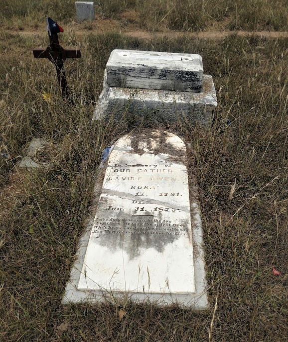
Morgan Stacy built a store at the community site and ran the post office when it was granted in 1890. In 1892 the community had a flour mill and gin, a general store, and a Baptist church. The first school was a one-room structure built in 1893. In 1896, the Cornils deeded five acres for a free public school adjacent to a community burial ground on their property. Several unmarked graves predate the first recorded burial, that of Heinrich Rudolph (d. 1883).

Separated about a mile apart, there are two cemeteries; the Lohn Family Cemetery (GC7QD68) and the Lohn (Community) Cemetery (GC7QD61). There weren't any geocaches hidden in either cemetery. So of course I had to remedy that situation.


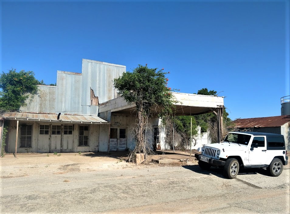
New businesses were built from around 1910 through the 1920's, and the number of residents increased from seventy-five in 1914 to a high of 360 in 1931. The Lohn population was 250 in the 1940's and 1950's, but it fell to 100 in the mid-1960's. In 1988 two businesses and 149 residents were reported there; the population of Lohn was still estimated at 149 in 2000. The first photo below is an abandoned gas station followed by one of the abandoned houses.


A few miles west down Ranch Road 504 is Pear Valley, Texas and my next few geocaches. It began about 1908 as a widely scattered settlement called Saddle Creek. When the post office opened in 1910, the name was changed to Pear Valley. The population remained stable at forty-five from the 1930's to the 1960's. In 1964 it fell to twenty. Two churches and two businesses appeared on the 1987 county highway map, and the town reported thirty-seven residents in 1990. The remains of the school, built in 1935 (GC48A5, GC11BB1), General Store building, and the cemetery (GC5ADBJ) are about all that remain.


My next stop and geocache (GC11BB2) was in the ghost town of Salt Gap, Texas. Located at the intersection of County FM 503 and FM 504, it had a population of just 25 in 1990. Named for the local creek of the same name, the town had a post office in operation from 1905 to 1913 - the year it closed. It reopened in the 1920's and closed for good several years later. The population high-water mark was 60 people in the late 1930's. The town never developed past the store and school stage, but it remained a viable community in 2006 and still appears on the county map. Not much to see here but the signs announcing its existence and a few buildings at the intersection.

A few miles around the corner from there was another ghost town that really had my interest. The early settlers of Doole, Texas (GC11BAX) wanted to name their town in honor of a prominent family in the area, the Gansel Family, therefore this farming and ranching community was originally known as Gansel, Texas. Residents decided to establish a post office in approximately 1911 and ask the postmaster at Brady, Texas for advice. The postal service in Washington D.C. said that the name Gansel was unacceptable, so the settlers named their post office and town after David Doole, Jr., the postmaster at Brady. These are just a few of the many photos I took in Doole.

The Old Doole Baptist Church

Gray's Machine Shop which handled all the auto and tractor repairs, welding, and blacksmith.

Old House with Porch Swing


This was to me the most fascinating part. A lot of towns have old buildings. But how about the school sports stadium where the bleachers were built into the side of the hill! Kinda like ones I saw of the ancient ruins in Athens, Greece. Even had the old ticket booth standing and still in decent shape. There's even an old rusty 1957 Plymouth sitting in the mesquite where the parking lot probably was. Darned if I forgot to take a photo of it though. This ghost town is definitely one of the must see on a roadtrip through Central/West Texas!


Continuing slowly westbound, I arrive in Millersview in Concho County and my next two geocaches (GC11BBB, GC5ADC4). Named for Edward D. Miller, who co-founded the town with one Henry Barr. Previous settlement had been scattered along Mustang Creek - some seven miles NE of present day Millersview. The town was granted a post office in 1903.

In 1914 the town had a population of 160. From 300 people in 1931, it was reduced by two thirds by 1933 but somehow managed to rise to 250 as the Depression was winding down. The Millersview school had eight teachers in 1940 to teach both elementary and high school grades. High school classes were suspended in 1958 although elementary classes continued until the school closed sometime before 1989. The population was 175 in 1963, declining thereafter to 70 by 1970 - an estimate that stayed in place for thirty years. Students from Millersville now attend classes in Eden. The school itself is now degrading, but the people have restored the gymnasium (built in 1939) and continue to use it as a community center.

The community is reportedly the only town in the United States using the name Millersview.


Also in Millersview is the Our Lady of Guadalupe Catholic Church. They have erected a monument and marker in 1998 honoring the Mission San Clemente. The mission was established in 1684 by Spanish missionaries for the purpose of sharing the Catholic faith with Indians in the area. In 1984 mass was celebrated at this location to commemorate the founding of the mission 300 years ago. A congregation of more than 3,000 joined many of the Texas Bishops in the Liturgy.


My next geocache was a roadside cache on FM 765 on the way to the ghost town of Eola, Texas. The Eola Museum cache (GC10V2A) is at the corner of a dirt road leading to the Barrow Ranch. Earnest and Dorthy Barrow founded the Museum in 1976 to house their extensive collection of memorabilia from the early days of Concho County. It has since grown to include items from all over the world, collected by the Barrows and many other donors. As a gift in perpetuity to the public, the Museum is owned and operated as a non-profit foundation by a Board of Directors.

Four large buildings house the collections that range from delicate crystal to a magnificent pipe organ. Visitors can step back into history as they view many different antiques. Some of the largest collections contain thousands of cat figurines, hundreds of Hummel and Goebel figurines as well as thousands of arrowheads and other Indian artifacts. There are also gems, minerals, cars, farm equipment, medical and dental equipment, windmills, and seashells of all types.

I didn't have the time to drive down the road to see the museum. Maybe another day I just might.

Another side road so that I don't have to backtrack, and I arrive at Henderson Chapel, Texas (GC1DZFX). Henderson Chapel, also known as Hendersons Chapel and as Henderson, was near a tributary of Kickapoo Creek. In 1936 Henderson Chapel had a business and a school. In 1940 its school, which encompassed grades one through seven, had an average daily attendance of twenty. By 1955 the community's school had been consolidated with the Eola school district. The 1963 county highway map named the community, but showed no buildings at the site. The only thing I saw was this building which is barely standing and overtaken by trees.


Finally reaching Eola, Texas, the area was originally called Jordan. However it changed its name in 1902 when the first store was built and the town only had four families. Eola was created during a land boom when county school lands were put up for sale at fifty cents an acre in the 1890's. The sale attracted many Europeans – primarily Czechs.

A two-story schoolhouse was built in 1906. By 1914 Eola had a population of twenty-five which grew to 240 by 1931. In 1940 Eola had a population of 250 and was thriving. It reached its zenith in ’47 when 350 Eolans called the town home. Nine teachers taught elementary and high school classes.

Recently a carpenter from Washington moved in and has been restoring the old school building a little at a time. He also opened up a steak house on one end and is only open Friday and Saturday to help raise money for the restoration project. I thought I had taken a photo of the school, but I guess I didn't.

A few miles north of Eola is the Mereta-Eola Cemetery (GC1DZGE). Not a whole lot of history other than it serving the towns of Mereta to the west and Eola to the south. Still in use today with just under 100 burials listed, it dates back to the late 1800's.


My last two geocaches for the day are in Mereta, Texas (GC1ABHM, GC10V2C). Mereta, also known as Fisherville and as Lipan, was named by its postmaster in 1902 for twin sisters Meta and Reta Burns, had a gin, two stores, and a school in 1904, when a town plat was made. Its population fell from seventy-five in 1914 to thirty in 1925. In 1931 Mereta had three businesses and a school with three teachers; by 1934 the community's population was reported as ten, with four businesses. The 1936 county highway map showed two churches, two factories, a post office, a school, and scattered dwellings at the town site. By 1939 a store was operating at the local community center. The population of Mereta was estimated at seventy-five from the early 1940’s through the early 1990’s. The 1984 county highway map showed a church, a business, and a park.


That was it for today. Spent enough time on these little backroads and ghost towns. I still had 180 miles of driving before reaching Fort Stockton. Gotta get moving. Thanks for riding along and be sure to either Follow Me via the button on the right (if you're on you computer), and on Facebook or Twitter for the latest updates.

Saturday, April 4, 2020

2018-05-20: Exploring and Geocaching in the Historic Town of Mason, Texas

On this weeks long drive from Killeen to Fort Stockton, I spent most of the day exploring and geocaching in the historic town of Mason, Texas.


One of the first settlers in the area was William. S. Gamel in 1846. Fort Mason was established in 1851 and settlers were attracted by the protection that the fort provided from Indians. Germans moved into the area from Fredericksburg and even soldiers settled the town after their discharge. In 1858 the town received mail as well as the fort's supplies from San Antonio. The post office opened in town and the name was changed from Fort Mason to Mason that same year.

In the 1870's Mason County was the scene of a violent feud between German settlers and Anglo ranchers. Known as the "Hoo-Doo" War or the Mason County War - it was a nasty business of many killings with no one ever standing trial.

Mason became a stage stop after the war and it never did get a railroad - usually a very important milestone to a developing town. In 1923 Mason was the largest "city" in Texas without a railroad.


My first stop and geocache was at the Gooch Cemetery (GC1NVFD). There are over 2600 burials in the Old and New sections combined. I couldn't find any information on Benjamin Gooch other than he was born in 1790 in North Carolina. The inscription on his headstone reads: "Christian Patriot, Pioneer in Texas, Under Four Flags, 1834-1872." I can only assume that he was the initial donor of land used for the cemetery.

One burial of interest is that of Adolph Korn. Eleven-year-old Adolph Korn was tending sheep on New Year’s Day, 1870, when three Apache warriors came up to him on horseback. One of the warriors grabbed Adolph, hit him over the head with a gun barrel, pulled him onto his horse, and rode away. That was the last his family saw of him until three years later, when a band of Comanches, who had received the boy in a trade with his abductors, surrendered him to government authorities November 14, 1872, at Fort Sill, Indian Territory (Oklahoma).


He lived with the Comanches for only a few years but was "Indianized" by the experience. After being returned to his family, Adolph never again became completely comfortable with "white" civilization. He withdrew from his family and the community and lived in a cave for a number of years. His last years were spent with his sister Johanna spending most of his time outside, eating raw meat, sleeping outdoors, and avoiding contact with people.

And then there's Private Walton Tart. With the inscription of Texas PVT 636 TD BN and died December 12, 1944 at age 24, I can only assume he was killed in action though I could not find any additional information to verify that.


One more that caught my attention.
The next geocache brought me to the Seaquist Home and the Broad Street Bridge (GC1NVFK). Construction began on the Seaquist Home in 1887 by the Rev. Thomas Broad. In 1891, Banker E. M. Reynolds acquired and enlarged the house. The architect, Richard E. Grosse, also did the ornate stone cutting and woodcarving. Property was then sold to Oscar E. Seaquist in 1919, a Swedish immigrant, who finished the ornate house. This beautiful landmark still owned and occupied by his family. Exemplifying fine workmanship and materials, the house features a third-floor ballroom.


On the same street at the north corner of the property is the Broad Street Bridge. In 1914, the citizens of Mason petitioned the county commissioners court for a reliable means of crossing Comanche Creek, which separated north and south Mason. Initial construction bids were deemed too high and a second petition was presented in 1917. Because Mason had no railroad to transport large pre-fabricated building materials, the Alamo Construction Company crafted the bridge of reinforced concrete on site in 1918. Perhaps the last concrete truss bridge to remain in Texas, the Broad Street Bridge continued to support vehicular and pedestrian traffic in Mason until recently when bollards were installed to block cars from crossing.


Next up is a statue outside the Mason Library honoring its hometown author Fred Gibson (GC1195B). If you're as old as I am, you probably remember reading or watching the movie "Old Yeller" in grade school. The author Fred Gibson was born here in Mason, Texas.


Making my way back to the town square, I stop at the Mason County Jail. A good example of a small, nineteenth-century jail, this structure was built in 1894 from the brown sandstone available in the nearby hills. The ground floor of the county's third jail includes living quarters for the sheriff, while the jail cells are located on the second floor. The modified Romanesque revival building features a massive entry arch, segmental arches over the windows, and a central tower.


My next geocache was at the Old Mason Grammar School (GC13165). Located near Gamel Springs on the grounds of Fort Mason and constructed in 1887. Builder August Brockmann used stones from the former Fort, which were originally quarried on this hill. The school served Mason until 1952, with curriculum including music and German. In the 1960's, the building was used as a library, museum, and youth center. Now it is just the museum and senior center.


Old wagon behind the old school.
German immigrant Anna Mebus (1843-1925) came to Texas in 1858 and married her merchant cousin, Karl Martin (1828-1879). After his death she continued to operate their Mason store and post office, and by the 1880s was handling the cash of area ranchers. In 1901 she helped establish and became president of The Commercial Bank, opened with $3,000 capital. Before a bank building was acquired in 1903, cash was taken home at night. Her sons, Charles (1861-1940) and Max (1863-1941), served as bank officers and helped coin the bank's motto, Safety-Service-Silence. The family operated the bank until 1958.


Sitting proud in the center of the square is the Mason County Courthouse. Constructed in 1909, this is the third courthouse to serve the people of Mason County. Commissioners Court probably met in other locations until the first courthouse was built in 1872. It burned in 1877 and was replaced that year by a second red sandstone building. That one caught fire in 1900. Designed by E. C. Hosford, this Beaux Arts style third courthouse features a center dome and clock tower, gable front porticoes, with two story Doric columns and rusticated stonework with contrasting stone lintels.


Now off to visit the towns namesake. Fort Mason (GC181Q3) is situated near a spring long used by Indians; built of stone quarried from post hill. The Fort helped protect Texas frontier from Indians. Colonel Robert E. Lee, stationed in Texas 2 years, commanded Fort Mason from February 1860 to February 1861. Here he made his decision as to his part in the Civil War, saying: "If the Union is dissolved,... I shall return to my native state and... save in defense... draw my sword on none". He left Fort Mason February 13, 1861. In wartime he remembered "the enemy never sees the backs of Texans".

The fort was abandoned in 1969. The native stone buildings, which once numbered 25 were spirited away (stone by stone) to reappear in town, transformed into residences. In the mid 1970's the pattern was reversed when local citizens rebuilt a former officer’s quarters from the well-used rock.


On my way out of town, I stopped at the Crosby Cemetery and my next geocache (GC1NVFP). The first burial ground for the citizens of Mason and Koocksville, this cemetery traces its history to the 1850's. The oldest documented burial is that of Kate Lemburg, who died in 1856. Also interred here is Mason County's first sheriff, Thomas Milligan (1810-1860). The Crosby family purchased the property surrounding the cemetery in 1866, and it has been known as Crosby Cemetery since that time. Those buried in the cemetery include members of the Crosby and other pioneer families. It stands as a reflection of the area's heritage.


My last geocache of the day was on the outskirts of Mason in what used to be the town of Koocksville (GC1195E). The towns namesake(s) were William and Minna Koock who opened a store in their log house just after the Civil War. Due to its proximity to Mason, the Koocks never saw the need to apply for a post office. Koock's store became a stop for cattle buyers from more western counties.

The log store/ residence was rebuilt as a large stone structure in 1883. The building's second floor served as a community center and a place to hold civic meetings. The town thrived after the Civil War and the new prosperity made Koock a banker as well as a storekeeper. Koock later built a large flour mill and gin on his property but it was torn down and the stone cannibalized to build the VFD building in Mason. Koockvsille did have its own school at one point.

A decline in cattle and sheep prices sent the town into a slump, but when William Koock was killed in a riding accident (1890) his family moved into Mason and eventually sold the businesses (1899). Without the driving force of William Koock, the town would've become a ghost, but it's nearness to Mason has caused it to evolve into part of that city.


While driving the rural backroads of Texas, you never know what you're gonna see.


Just one more stop to make. Last week I mentioned stopping by Gamel Cemetery. I also mentioned William Gamel at the start of this blog as one of the earliest settlers in Mason County, moving here from Georgia. This land was a part of his homestead and you'll find his grave among those here. The oldest known burial is from 1883.

You have to cross this creek to get to the cemetery. Last week it was dry. This week there was a little bit of water there. I did manage to hide a cache there too (GC7Q19Q).


That's it for this week. The rest of the drive was straight through to Fort Stockton and getting ready for work tomorrow. Thanks for stopping by.

Sunday, March 22, 2020

2018-05-13: More Geocaches, a Bridge With a Swing, Ghost Towns, Cemeteries, and Texas History

On today's 360+ mile drive in my new GeoJeep, I find a swing on a bridge, some old cemeteries, an abandoned ranch house, a missing motel, and much more. There's a lot to see in Texas, so let's get started.

My first stop after leaving Killeen is the Bear Creek Cemetery in Bertram and my first two geocaches (GC7DVVQ, GC442E2). Established in 1865, this cemetery has over 1500 permanent residents here. This one in particular is Texas Ranger Millard S. Moreland who died in 1891 at age 35.


Continuing westbound on Hwy 29, I arrive at the Colorado River and the Old Inks Lake Bridge. Built by the Austin Bridge Company in the mid-1930's, this truss bridge is now a pedestrian bridge after the new bridge was built along side. I parked at the east end to grab that first cache (GCMQ7H) near the entrance.

I started to walk down towards the other geocache on the bridge, but it was almost to the other side. Plus the last few cachers had logged DNF's. Having second thoughts, I was about to turn around back to the GeoJeep. But then I figured I'd walk across and get some good photos from the middle. Well it was a good thing I did. I've been on plenty of old bridges. But this was the first time I ever saw a swing on one! (See the first pick up top.) Now that's what you call a swinging bridge! Took some more pictures, then looked and looked and found the missing geocache (GC52MVG).


Moving along down the road, I exit from Hwy 29 onto US-377 in the community of Grit, Texas. A few miles down from there I stopped for a quick roadside geocache called Weird Rock Ranch (GCZMJT).

A couple of miles later there was another roadside geocache for a Texas ghost town called Streeter (GC11953). The first settlers were Irish (1855) and within a few years they were joined by German immigrants. Settlement was first along Big and Little creeks and Honey Creek and the town was first known as either Bluff Creek Community or Honey Creek Community.

In September, 1890, a post office was established and the submitted name was Streeter after early settler Samuel T, Streeter. In 1870 a Baptist church formed and the town had a cotton gin and a flour mill. There had been a school, earlier, on Honey Creek, but Streeter didn't have a school of their own until 1900. Streeter was quarantined for smallpox in 1903 and telephone service began in 1917. The post office closed its doors in 1970. The population of Streeter which had been reported as 100 people from 1925 dropped to only 60 by 1964. Streeter has since rebounded to about 100 people.

Nothing to see except the old house near the cache which was buried deep in the trees and overgrown brush. Supposed to be a cemetery there too but not exactly sure where.

I did find Gamel Cemetery to the southwest. There wasn't a geocache hidden there and unfortunately all of my geocache supplies were back in the GeoPrius in Fort Stockton. But I did look around a little bit at the headstones and hiding places. I'll talk a little more about this cemetery when I return to hide a geocache soon.


Continuing southwest on US-377 towards I-10, I got off the main road to get to my next geocache. On the corner was this old abandoned house engulfed by nature. It would have been cool to go in and explore, but being on private property that's not such a good idea.


I made it to Red Creek Cemetery (GC1JR4E). Red Creek Cemetery is located in Kimble County. There is no sign identifying the cemetery.There is no historical marker. The land for Red Creek Cemetery was donated to the Community by Frank Latta on 23 May 1896, to be used "for general burial purposes." The first marked grave is that of T. Roy Black (31 August 1897). Frank Latta was laid to rest here 23 March, 1902.

Three young men who made the supreme sacrifice for their country repose here in final rest. Thomas St. Clair lost his life in World War I in Europe; a memorial stone in tribute to Lloyd G. Ivy was placed here following his courageous death in World War II; and John Wilbur Gentry (World War II) rests here. The latter's brother, Lawrence Gentry, lost his life while serving as a military mechanic during the second World conflict. At least eleven veterans of the Civil War - one who served the Union Army and ten who fought for the Confederate cause - are among early settlers buried in Red Creek cemetery.


Continuing south on Ranch Road 385 for a couple of miles, I arrived at my next geocache at the ghost town of Yates, Texas (GC1M4K5). Yates, also known as Yates Crossing, is twelve miles northeast of Junction in eastern Kimble County. It was named by Joseph A. Yates, who opened a post office in June 1907 on his land near a ford of the Llano River on the road from London to Fredericksburg.

Camp meetings were held by early settlers under the live oaks near Yates. Tully J. Lange became Yates's second and final postmaster in June 1909. By the 1920's Yates was the center of a farming community in the Llano River valley. Throughout the decade Yates had a post office, a general store, a gas station, and a population that reached at least fifty-one. The area was advertised as a vacation spot for tourists and campers.

The post office closed in March 1930, and though Yates continues to be shown on maps, its last reported population was ten in 1958. Aside from a few scattered houses, the only thing business related that I saw was this old Kimble Motel sign.


Through Yates on this same spot on the Llano River is the Old Beef Trail Crossing. This Llano River crossing became a main line of the Spring cattle drives from 1867 to the 1880's. Capt C. A. Schreiner and his partners herded cattle on their way to Abilene and Dodge City on the Western Trail; many area cowboys rode with them. Preceded by a trail boss and chuck wagon, as many as 2,000 cattle per herd took half a day to cross. With the air full of dust, local ranchers sat on their own horses watching their own cattle closely to ensure that none of their own herd joined the trail drive. This site later became a vehicle crossing.


Back on US-377 south, I caught this old truck parked by this broken windmill and had to turn around for a photo.


Just down the road was my next roadside geocache near a historical marker (GC1M4J3). Teacup Mountain was named for its peculiar formation. Probably used as a lookout post by both whites and Indians in pioneer days. Near here occurred the Indian killing of pioneer James Bradbury Sr., 1872; and the capture of a wanted man by Lt N.O. Reynolds and four fellow Texas Rangers in 1878.


Named for the soaring Teacup “Mountain” to the west of the site, not much is known of this community other than there were 10 inhabitants at one time and they were served by a single store. The post office “may” have been located in the general store according to The Handbook of Texas. 1947 was the last year anyone bothered to count the number of residents and now there’s no one left to ask.

My last geocache of this trip was at Gentry Creek Cemetery (GC1M4HX). Raleigh Gentry was one of the first settlers in Kimble County, coming to the county in the early 1850's, when he settled on Bear Creek, some five miles with its junction with the North Llano. Here he built a home, erected stables, corrals, outhouses, cleared land and had an ideal paradise from a material standpoint. He prospered, farmed enough land to produce grain for use of his family and his stock, raised cattle, and enough hogs for his family use. In the early 1860's the war clouds gathered and became darker and darker, and finally the able bodied men had to go to war or join the frontier defense. Raleigh Gentry had six stalwart sons; Alan, Lee, Guliford, William, George, and Jack.


His son William married Nancy Frazier, but he answered the call of the Southland and joined the Confederate forces. He left his wife and son John at home, never to return.

In 1862, Raleigh Gentry sold his holdings on Bear Creek and moved some fifteen miles northeast and made a new location, now known as Gentry Creek, but here trouble awaited them. The Indians taking advantage of the lonely situation and the further fact that many of the men folks had gone to fight with the South made repeated raids on Gentry Creek, stealing horses and killing anyone that got in their way. On one occasion, two of the Gentry boys were hunting horses about a mile from home, when they saw the horse herd surrounded by a band of Indians and being driven off. The boys escaped to their home.

In 1867 Allen Gentry and his brother, Lee, went northeast to the Little Saline on a hog hunt and were soon joined by Felix Hale. Their hunt led over the line into Mason County. The part divided, Allen Gentry took one side of the creek, and Felix Hale and Lee another side in their hunt for the hogs. Allen was attacked by the Indians and killed in the very sight of his brother, Lee, who wanted to rush to the defense of his brother but he was told by Felix that it would be suicide and he would lose his own life. Hale and Lee dashed to the first neighbors' and gave the alarm, and parties organized to rescue the body of Allen Gentry and also to pursue the Indians. The body was found and placed on a blanket, and the four corners tied to a long green pole, and in this was the frontiersmen formed a hearse and conveyed the body to the residence of Matthew A. Doyle, the nearest neighbor, a distance of four miles. Here the body was placed in a hack and carried to the Gentry Creek. The body was buried in what developed into the Gentry Creek Cemetery.


Another buried here and worth mentioning is Dan C, Bird, grandson of George C. Kimble, an Alamo hero for whom Kimble County is named. Bird's son, Jack, passed away in California in 1981, and according to his wishes, Jack's cremated remains were scattered above Teacup Mountain that looms in the distance from Gentry Creek Cemetery.

That was it for today. Drove onto I-10 at Junction all the way to Fort Stockton. Thanks for stopping by and we'll see you next week for another tour of Texas.