Saturday, November 28, 2020

2019-03-09: A Packed Geocaching Roadtrip Returning from Minnesota to Texas: Day 3 in Kansas and Oklahoma

Hello again and welcome to Day 3 of the roadtrip returning from a business meeting in Minnesota and driving back to Texas. CuteLittleFuzzyMonkey (CLFM) and I took three days driving from TX to MN. Do we make it back to Texas today? Let's get going and see...

We left Manhattan, Kansas at sunrise and headed east on US-24 down the road into Wamego, KS. The town of Wamego is the birthplace of Walter P. Chrysler. You'll also find the Columbian Theater where you can see turn-of-the-century murals from the 1893 Chicago Worlds Fair. Probably the most popular attraction is the OZ Museum and all the Toto statues around town.


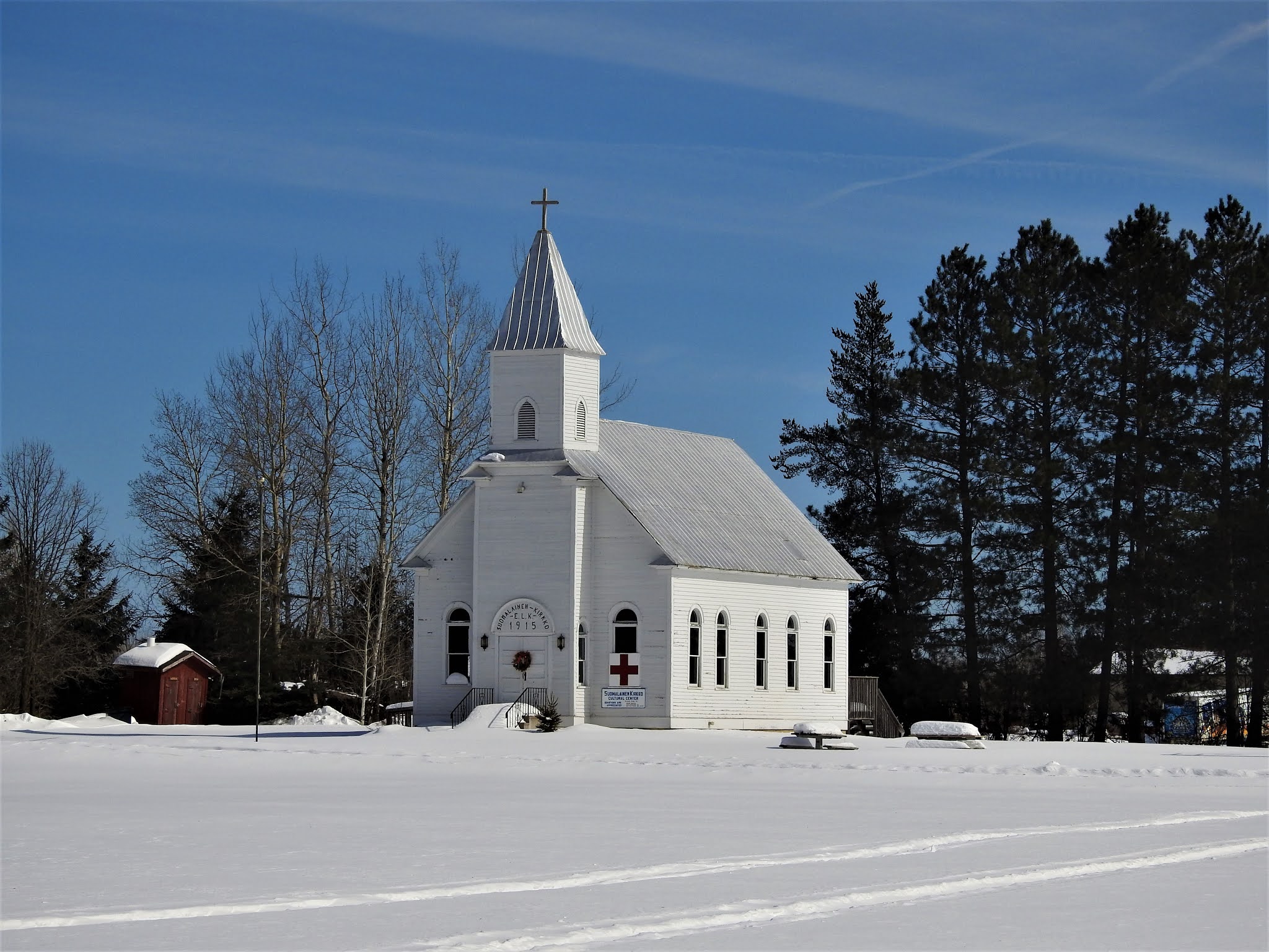
But what CLFM and I came for was our first geocache, a webcam geocache (GCPGXD). There were several webcams around town. We took our pose in front of the United Methodist Church.


Our final stop before leaving town was the Old Dutch Mill (GC83C3) virtual cache. Built in 1879 by Dutch immigrant John B. Schonhoff on his farm twelve miles north of Wamego, this old mill was used to grind grain into flour and cornmeal. In 1925, thirty-five team and wagons moved the windmill to this site. Each stone was taken down, numbered, and rebuilt exactly as the original. A bust of Ceres, goddess of grain, is set above the window. The mill is 25 feet in diameter and forty feet high.


Then we backtracked a few miles to Manhattan, KS because we forgot about the virtual geocache at the Kansas State Vietnam Veterans Memorial (GC6887).

Heading south on Hwy 177 for a few miles, we arrived at Konza Prairie Research Nature Preserve. The Konza Prairie located in the Flint Hills and is managed by Kansas State University as a long term ecological research site. This vast ecological system provides some spectacular views as you arrive at the visitors center. This was once part of the 2923 acre Dewey Ranch and was purchased in sections by the Nature Conservancy and Kansas State University from 1971 to 1979 for a total of 8600 acres today. The Konza Prairie was named after the Konza Indians. It also offers a trail system that can be combined for a 6 mile loop.

There was a virtual geocache and an earthcache along the highway (GCB63B, GC1DJV8). Then there was another virtual geocache (GC6E84) on the westside of the preserve as well as another virtual "Ashland Community" (GC6E86) outside to the north. Looking at the satellite imagery, it looked like we should be able to drive around the outside and get both of those. We really weren't up for the 6 mile hike at this time. So we gave it a shot.

Getting to the Ashland Community was pretty easy and we parked right out front of the historical building. Then following Google Earth, we continued down the muddy road around and into the westside of the preserve. Drove right up to within a couple hundred feet of the old water well. Sure made it easier than a long hike. And with the muddy conditions, I got to put the GeoJeep in 4x4 mode again.


Now jumping onto I-70 west for a short trip to the hill overlooking Fort Riley. This virtual geocache brings us to an Atomic Cannon (GC698E). Now I've never even heard of an atomic cannon! This is why I love geocaching! According to the historical marker at the site of the cannon: "This is one of only three atomic cannons in existence. The other two are located at Ft. Sill, Oklahoma and the U.S. Army Ordinance Center in Aberdeen, Maryland. This cannon was placed in service on November 17, 1952 and was deactivated in August 1963. Two 375 HP engines were used to transport the 42-foot, 280-mm cannon at 35 M.P.H. to the desired firing locations. The cannon can fire a projectile 11 inches in diameter for more than 20 miles. This cannon was never fired."

From the parking area, you can see the barrel of the massive cannon pointing outward. Standing next to it, it's like the huge cannons on a Navy battleship. Looking back downhill, that's CLFM nearby, I-70 going left to right, Junction City to the far left, and Fort Riley way off in the distant right side.


Driving on US-77 southbound in Herington, KS, we stop at the Father Padilla Memorial Park. There we find a not-as-big-cannon and our next virtual geocache (GCACE0). It seems like a pea shooter by comparison.


At the park across the street was this bench that was just calling out for me to take a photo!


Back to I-70 westbound, we take a ride over to Abilene, Kansas. There we found a large boulder which marks the northern terminus of the Texas Cattle Trail (GCGA9K). The plaque gives a little history, including the following, over three million cattle were delivered here. The trail was in operation from 1867 to 1871. The dollars brought in by the cattle trade and those hustling the cowboys gave Abilene the foundation of prosperity that still carry it today. The wild wild west was definitely here! Gunfights in the street, fistfights in the saloons, and prostitutes working the cowboys made for many wild nights. The upper class citizens of Abilene desired a more reputable image and laws were passed here that brought the cattle trade to an end. The cattle drives moved west to cities like Ellsworth, Hays and Dodge. Abilene continued to prosper without the cattle trade and is still a successful community.

Also in Abilene, you'll find the Dwight D. Eisenhower Presidential Library and Museum. And of course it's also another virtual geocache (GCBB05). President Eisenhower was born in Texas and lived there until age 1 1/2. His parents then moved back to Abilene. There he grew up and remained until he joined the military. Even though after his military and political career he moved to Gettysburg, he always considered Abilene his hometown and where his Library and Museum was built.


Next on our target list was a virtual geocache at the site of the Old Salina Brick and Tile Company (GC2E7C). We got the required bit of information needed for the answer and moved on.

Also located in Salina, Kansas is some aviation history (GC7B69P). In 1942 the Smoky Hill Army Airfield was constructed southwest of Salina. When the base closed in 1967 it left Salina with one of the largest Municipal Airport runways in the world. Turns out that wasn't the end of Salina's aviation story. For many years aircraft parts were built in several of the old base buildings by several familiar manufacturers. In more recent years it has become home to K-State Polytechnic with pilot programs in flight including a unmanned flight program. Military aircraft are still a common site at the airport with several reserve units having training facilities on the airport properties. 38 years after the closing of the military airfield a record breaking round the world flight took off (02/28/05) and landed (03/03/05) on the historic runway. The "Global Flyer" was quite an event and this monument is the centerpiece of a newly dedicated park with extensive history of the Airfield.


Heading south from Salina on I-135, we go down a short drive to Coronado Heights Park (GC3483). Located up on a hill overlooking Saline and McPherson Counties. Coronado Heights receives its name from Spanish Explorer Francisco Vasquez de Coronado who visited central Kansas in 1541. He was looking for the Native American community of Quivira where he was told "trees hung with golden bells, and pots and pans were beaten of gold." Coronado didn't find his gold.

In the 1930's, the Works Progress Administration built a picnic area and castle like building out of Dakota limestone. There was also a traditional geocache hidden a short walk down one of the trails (GC1TNG5).


Continuing southbound on I-135, there's a roadside attraction photo opp and our next virtual geocache (GC348A). Though I don't know how I missed taking a photo myself. So I'll use CLFM's photo. This used to be the "Happy Chef" which stood outside the Happy Chef Restaurant in McPherson. Someone bought it and moved it here. Now it looks like Mr Moneybags from the Monopoly game.


On the way to Canton to pay respects to Edgar Miller, we found two geocaches (GC824R0, GCG6V6) on the road to and in the cemetery. Edgar was an 18 year old ranch hand who bravely rode across the prairie to get help for his bosses wife who was very ill. He was captured by Cheyenne warriors who tortured, scalped, and murdered him, leaving his body in the weeds. For the complete riveting story, visit the Santa Fe Trail Research website.


Then there's the "Nothing But Blue Sky" virtual geocache in Newton, KS (GCAE93). Located in Centennial Park is this huge piece of artwork sculpture created by three artists.


Finally making it down into Oklahoma, we make string of geocaching stops in cemeteries to claim new counties. One cemetery geocache in each county of Alfalfa (GC2BFZ3), Grant (GC3NNQM), Garfield (GC71GHP), Kingfisher (GCMJND), Blaine (GC4J0Y3), and Caddo (GC7KGVK).

By now it's getting late, already dark, but we're still going on. Also in Caddo County, in the town of Anadarko, OK, we stop by the former Rock Island Railroad Depot (GCGA01). Built in 1902, it is now a museum and a virtual geocache. The museum was closed at 9:30 PM while we were there, but I did manage to see the cool old fire truck parked out front.


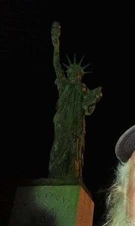
Moving down to Grady County, we get our last cache for the day. A virtual geocache for another one of those miniature Statue of Liberty monuments (GCFC05).


We finish the day near midnight finally getting some sleep down in Lawton, OK. Twenty-eight geocaches, about a dozen new counties, and nearly 18 hours later I'm exhausted! But it was a great day for geocaching and sightseeing through history.

Until tomorrow... ZZZzzzzz........

Tuesday, November 24, 2020

2019-03-08: A Packed Geocaching Roadtrip Returning from Minnesota to Texas: Day 2 in MN, SD, NE, and KS

Hey everyone! I'm glad you made it back to check in on our progress. If you're just joining us, I had a fly in / fly out business trip and turned it into a week long geocaching roadtrip! I recruited my friend and fellow geocacher CuteLittleFuzzyMonkey (CLFM) to go along for the ride. He also did the cache planning and route navigating for the trip.

To catch up to where we are now:
Day 1: Texas to Minnesota in TX & OK
Day 2: Texas to Minnesota in OK, KS, & MO
Day 3: Texas to Minnesota in NE, IA, & MN
Day 1: Minnesota to Texas still in MN

So today we started out in Saint Cloud, Minnesota. Checking out of the hotel at sunrise, our first stop was the parking lot to grab a simple LPC (GC62YJN).

Driving southbound, we stopped in Willmar, MN for our next cache to claim a find in Kandiyohi County. It was the Point Lake Travel Bug Hotel geocache (GCXZ87). This was one cache that I'm glad we're here in the winter with sub-freezing temperatures. While the geocache was hidden among the trees on the bank of the lake, the lake itself was frozen over with ice and snow! Being a Floridian / Texan, this was finally an opportunity to "walk on water." We took turns walking out onto the frozen lake and taking a photo.


Next up was a quick park & grab geocache (GC7AEPM) in Clara City, MN to claim a find in Chippewa County.

Then there was the Tri-State tri-corner virtual geocache (GC8809). Even though this monument sits on the corner of Minnesota, South Dakota, and Iowa, technically the coordinates are in South Dakota. This was my second tri-state cache in already this year! This one was much colder. Stepping out from the warm GeoJeep, I didn't feel like putting my heavy jacket back on. There was also a traditional cache placed there as well (GC41H35). So it was a 2fer location!


Our next geocache and another virtual (GCFBF1) was along US-18 on the eastside of Canton, SD. There are three roadside historical markers concerning this area. The one the cache focuses on was about the Norwegian immigrants and skiing. Since I don't want to give away the answers, I'll tell you what one of the other historical markers says: The Hiawatha Asylum For Insane Indians.

"Receiving Congressional appropriations in 1899, the Hiawatha Asylum for Insane Indians was the second federal mental hospital and the first dedicated to American Indians. The first patient arrived in 1902, and through 1934, more than 370 patients –ages two to eighty, from fifty tribes nationwide – lived here. Patients did domestic and agricultural work onsite, were occasionally shown to paying visitors, and underwent treatment with methods later deemed outdated and dehumanizing. From 1929 to 1933, federal inspectors found intolerable conditions, inadequate staffing, several sane patients kept by force, and numerous other abuses. In 1933, John Collier, the newly appointed Commissioner of Indian Affairs, ordered the asylum closed. G. J. Moen, with the Canton Chamber of Commerce, filed an injunction to keep the asylum open, but it was overturned in federal court. Many patients were discharged and those who still needed care were sent to St. Elizabeth’s Hospital, Washington, D.C. The major buildings used by the asylum have since been demolished. The Hiawatha Asylum cemetery, where at least 121 patients were buried in unmarked graves, is located between the 4th and 5th fairways of the Hiawatha Golf Club. In 1998, the cemetery was listed in the National Register of Historic Places.

Making our way down to Lincoln, Nebraska, our next two virtual geocaches (GCC963, GCB88C) were located at the Wyuka Cemetery. One cache was to recognize Albert Gordon MacRae (1921 – 1986) was an American actor, singer and radio / television host, who appeared in the film versions of two Rodgers and Hammerstein musicals, Oklahoma!

The other virtual was for an infamous 1950's serial killer. Inspiring the films "The Sadist" (1963), "Badlands" (1973), "Kalifornia" (1993), "Natural Born Killers" (1994), and "Starkweather" (2004). "A Case Study of Two Savages," a 1962 episode of the TV series Naked City, was also inspired by the Starkweather killings. More recently a "Criminal Minds" episode portrayed a newlywed killing spree very similar to the crimes of 19 year old Starkweather and his 14 year old girlfriend Fugate.

Also in Lincoln, NE was another virtual cache at the Lincoln Children's Zoo (GCGJQ1). The cache is highlights the Dakota Age Sandstone which is said to be 130 million years old.

South of Lincoln out in very rural Odell, NE is our next virtual geocache called "Oketo Cut Off" (GC8CCE). I'll give you much of the description from the historical marker without giving away the answers for the cache. During the 1860's, stagecoaches passed near here along the Oketo Cutoff. The cutoff diverged from the Ft Leavenworth to Ft Kearney Military Road northeast of Marysville, Kansas angled northwest to cross the Big Blue River near Oketo, KS and passed through the Otoe Indian Reservation just south of Odell. The cutoff rejoined the main trail between Steele City and Dillar, NE.

The stagecoach company owner, who had the government contract to carry mail and passengers from the Missouri River to California, ordered the cutoff laid out producing a shorter, better road and bypassing Marysville after the town refused to improve the Military Road. Although his coaches used the Oketo cutoff, freighters and other travelers continued to follow the Military Road which had been popular since the 1840's. After only a few months he abandoned the cutoff.

This metal sculpture was there along with the historical marker to recognize this historical trail. Kinda hard to see as it was already dark by the time we arrived.


Well it's late and it's dark out. However even if we wanted to call it a day and stop geocaching, we're out in the middle of nowhere and there's no hotel to be found anyway! So we keep going and have now dropped down into Kansas.

Just north of Concordia, KS, is our next target at the "Kansas POW Camp" virtual cache (GC4CAF). During World War II, 300,000 German Prisoners of War were interred in the United States. Three larger camps were located in Kansas, near Salina (Camp Phillips), at Fort Riley, and just outside Concordia, Kansas. Construction of Camp Concordia began in February, 1943 and the POW camp was turned over to the US Army on May 1, 1943. At its peak Camp Concordia had 4,027 Prisoners, over 800 soldiers and 179 civilian Employees.

Camp Concordia had 304 buildings including a 177 bed hospital, fire department, warehouses, cold storage, and officers club, and barracks, mess halls & administrative buildings for both the German POWs and American soldiers. All of the prisoners at Camp Concordia were members of the German Army. Most were captured in Africa, and the first POWs came from Rommel's Afrika Korps. Only the enlisted POWs worked, most of them on farms, but some worked on the railroad or in the ice plant.

Camp Concordia officially closed on November 8, 1945. Many of the buildings were torn down and others were moved. Some are still serving as homes in Concordia. The only structures remaining at the original location are Guard Post 20, a ware house, some stone walls, the officers club, a few foundations, and the tower which once supported a 100,000 gallon water tank. A two story stone guard tower has been reconstructed and pictured below.


There was one more virtual geocache we got that night before calling it quits. It was for the "Boston Corbett Dugout" (GCFF36). Along this rural Kansas road you will find a small monument which has been erected as a historical marker near the location of a Dugout once owned by Boston Corbett. Boston Corbett was an Army Sergeant who was with a detachment of soldiers searching for John Wilkes Booth. When they caught up with Booth, Corbett was credited and later discharged from the Army for the shot that killed Booth. It seems that Corbett made a spectacular shot through a crack in some barn siding, however Corbett was discharged for failing to follow orders in the shooting.

After being discharged, Corbett homesteaded in Kansas and made this dugout his home for awhile. The eccentric man had a run in with the local sheriff (after showing some local children the business end of his pistol) and through some sympathetic friends he landed a job at the state capital. After an incident where he displayed his 38 at the capital he was sent to the state insane asylum, which he quickly escaped from. He made his way to a friends house and was last seen jumping a train. There is no record of what happened to him after that.

Now getting to and from this last geocache was an adventure of its own! This rural Kansas farmland dirt road was now slushy mud with the melting snow. We were in 4x4 mode for several miles slipping and sliding. It was pitch black with no lights anywhere in site on the horizon. We had limited cell phone service and running low on gas. All we could see was the path before us from the headlights. I was doing my best to stay down the center of the road cause I wasn't sure if under the clean snow on the sides was a ditch. I knew that for the most part, my tires were spinning faster than we were moving! Traction was coming and going at best. I just knew that as long as I was moving forward, I did NOT want to ease off the gas.

After about 20-30 minutes at a slow pace, we finally made it out to a paved road. Now we can finally stop worrying about get stranded out in the middle of nowhere! We made our way to US-24 and followed it to Clay Center, KS. There we finally found a gas station and was able to take a look at the Jeep. I thought it would be covered in mud more than it was. I guess being the wet slushed snow blew off the last 15 or miles.


Still no hotel worth staying at, we continued east over to Manhattan, Kansas. There we were able to find a decent place to finally call it a day about 11 PM, a LONGGGGGG DAY!

Come back tomorrow and see how far we get. Do we make it back home to Texas or not? What other sights to we bring to you? You'll just have to wait and see.

There are new ways to follow me. Follow the blog directly by using buttons on the right of your computer screen. Or through various social media platforms:  FacebookMeWeParlerGabTwitterInstagramMAGAbook, and Reddit. Follow us on any or all of these platforms and whichever you choose, please leave your comments. We'd love to hear from you and it encourages us to continue sharing our adventures.

Monday, November 23, 2020

2019-03-07: A Packed Geocaching Roadtrip Returning from Minnesota to Texas: Day 1 Exploring Minnesota

Welcome back to the frigid cold of Minnesota in early March! After two days of sitting in a meeting room for some surveyor training for the latest Trimble software, it's time for me to get behind the wheel of the GeoJeep and head back to Texas.

My traveling geocacher sidekick CuteLittleFuzzyMonkey (CLFM) has been out driving all over Minnesota and Wisconsin the past two days finding geocaches. He'll be back in the passenger seat navigating the return trip and choosing which caches to go after.

We're up and out at sunrise to hit the road and beat the Minneapolis morning rush hour traffic. Our first two caches were just around the corner in a shopping center parking lot. These were two challenge caches hidden under a lamp post skirt. Normally easy park-n-grabs, but the snow and sub-freezing temps had these hard to lift open. Probably would have skipped these except being challenge caches, meaning that you had to fulfill the required challenge in order to claim the find. These were called 10x10 (GC37PR0) and 15x15 (GC3D5K7) Challenges. The requirement was to have found at least 10 caches in each of 10 different states and 15 caches in each of 15 different states. And as much as we get around, this was accomplished long ago!

Next up and also nearby was a virtual cache called Surveyor's Error (GC5882). As a surveyor myself and in town for some surveyor training, how could I even think of passing this one up! The piled up snow didn't make this one easy. (CLFM had already gotten this one 2 years earlier when he was in town on another trip.) At the location was a boulder with a plaque on it. It marked the Latitude of 45° 00' 000' which is the halfway point between the equator and the north pole. I got the required info I needed and we moved on. 

Passing through a neighborhood on the way to our next geocache (GC6CDV8), we saw this humorous sign by one of the residence. I just had to stop for a photo. I've always felt that snow was nice to go visit and see, but not to live and work in!


Slowly working our way north... wait Texas is south? But there are still virtual caches and geocaches of interest to the north! Like this virtual geocache at a Veterans Memorial at Bunker Hills Regional Park (GC74C7).


Heading northbound on I-35, we made a quick exit to grab a "Welcome to Wyoming" cache (GC5QW44) at the welcome sign for Wyoming, Minnesota. This also gave us Chisago County. Further up another quick stop for a virtual in Pine County at the Hinckley Museum (GC7B7YK). Got the info we needed on the outside, but the inside was still closed.

Then in Carlton County was a virtual geocache (GC8EB7) at a historical marker in a roadside picnic area to commemorate the early Finnish Settlers who came to the area in the 1870's. What caught my eye about a hundred yards behind it was the old church. And with all the snow on the ground, it made for a nice photo.


As with the first photo above, sometimes you see things that make you laugh and you have to stop and take a photo of it. Driving through Cloquet, we saw this laundromat and car wash combo. Ummm do you like drive through the car wash with your windows open and have your laundry washed at the same time? Do they have super-sized dent-less tumble driers for the cars? I'd hate to be in the car during the spin cycle! LOL!


Arriving in Duluth, MN with its rich history, there were several on our to-do list. First up was a virtual geocache at the statue of the mini-Lady Liberty (GC89E9). These are scattered all throughout the country. I remember my hometown back in Orlando, Florida had one.


Next up was a puzzle cache called "Hurry HARD!" (GC16REQ). Something about the sport of Curling. Anyway, I hate these puzzle caches because most I'm usually clueless on how to solve them. But CLFM is the Master Puzzler! So we found and signed the log for that geocache.

The Duluth Aerial Lift Bridge virtual cache was next (GC7B69H). The Aerial Lift Bridge was originally built in 1905 as a gondola bridge. It was converted to the lift bridge that you see today in 1929-1930. The bridge span weighs approximately 1000 tons (2 million pounds!). The weight is offset by two 500 ton weights on each end that allow the motors to move the span up and down with little effort. The horn you hear from the lift bridge is actually made up of two Westinghouse Airbrake locomotive horns. The span is 15' above the water when down and can raise as high as 135' above the water if necessary. It takes approximately three minutes for the bridge to rise to the top. When large ships are entering, the bridge will start its ascent when the ships are approximately a mile and a half from the bridge.

Being on the bridge, I couldn't get a decent photo of the bridge from the side obviously. However, it did allow me a great view of a frozen Lake Superior with both lighthouses: the Duluth Harbor South Breakwater Inner Light on the right forefront and the Duluth North Pier Lighthouse way out to the end on the left side of the photo.


Then there's an earthcache for a giant piece of floating copper (GC19AXB). This huge chunk of metal was dredged up in 1937 from the Keweenaw Waterway in Michigan.

The next virtual was a monument dedicated to remembering three men who lost their lives one dark day in Duluth back in 1920. Clayton, Jackson, and McGhie (GCGMGH) suffered an injustice that day and this memorial was built to remind us and not repeat the wrongs of the past.

Back in 1920 in Duluth, Minnesota there was an old fashion lynching. A young white girl made a claim that some blacks from the traveling circus raped her. The local police arrested several of the workers and placed them in the Duluth city jail. The news of this alleged rape spread through town like wildfire. Soon, a mob formed in front of the jail demanding justice. The police made a valiant effort (they were ordered not to use guns to stop the mob) but were not able to stop the mayhem. Three of the young black men were dragged from their cells and were savagely beaten and given a "kangaroo court trial". All 3 were then hanged from a lamp post while the mob gathered around for photo opportunities. The picture even was used as a postcard for several years.

Turns out the girl "more than likely" made up the story anyway. Another black man was convicted of the rape, then freed after serving 4 years of a 30 year sentenced because the evidence was later believed to be false and politically motivated. Three of the men in the mob were convicted of rioting and served about two and a half years for rioting. None for murder.


Around the corner on the next block I spotted this great architectural building and took a photo. Turns out it was the Old Central High School built in 1892. After a new high school was built in 1971, this building was granted historical designation. Today the Old Central High School houses offices for the school district, Education Equity, Indian Education, and the St. Louis County Soil & Water District. It also contains an 1890s classroom museum.


Arriving over in Aurora, we stopped at another historic building for another virtual geocache. Centered in Saint Louis County, MN, Aurora was plated in 1898 and a post office established in 1903. A few years later this historic City Hall was built (GCG4WF). On the north side of town was another virtual geocache at another not-as-old building (GCG4WM).

Now the main reason for sticking around here in Minnesota was to go for the oldest geocache in Minnesota. "Alvin's Phone Line" (GC9FF) was hidden November 5, 2000. This was definitely ranking in the top 5 of most challenging I've ever attempted!! Bushwacking the scrubs and swamps of Central Florida for 6 hours in 98° temps is the complete opposite but just as tough. We definitely needed proper clothing, snow shoes and perhaps a snowmobile for this one. But us southern cachers only come with jeans and work boots.

We drove up before sunset and went in about 300 feet and quickly turned around. Our legs and ankles were already frozen from the thick snow that soaked our jeans and snuck into the boots with each step. CLFM sent a message to the CO. To our delight and surprise he got a call right back. He quickly started the conversation off with y’all are stupid. We got some much needed advice and his hospitality was great. Now back at the GeoJeep we pondered while thawing out.

Looking around at what we had, I noticed some heavy duty jumbo sized trash bags and duct tape I use on the job site. We quickly grabbed a few and rigged ourselves some plastic bag waders. You know what they say that duck tape fixes everything. I don’t know about that but in this case it was a savior. CLFM put on his jolly green giant knit cap he bought at the museum the other day and used a pair of clean boxers to cover his face. I wasn't so bold and just tightened my hoodie!

Now we looked awfully funny, but we weren’t wet and cold and that made all the difference in the world. Probably should invest in some snow shoes and winter clothing. But would we ever get the chance to use them again? Lots of caches and their attributes steered us wrong today but you better heed the warning on this one and read the logs. Hardest T3 ever! More like a T10 in the winter!

We got back to the GeoJeep and said "Damn, we gotta go back to take pictures!" NOT!! It's gonna take us a MONTH to thaw back out again! LOL

Heading south now down in Crow Wing County, we stopped for another virtual geocache in the town of Pequot Lakes. This one is called "The Bobber" (GC7B8N8) due to the fact that its water tower is painted to look like a fishing bobber. It is kinda hard to tell in this photo cause it's nearly 9 PM when we arrived here. Going on 14 hours of geocaching and we're not done yet.


Continuing southbound, we made a quick stop in Little Falls, MN for a park and grab cache (GC65TQ3) to claim Morrison County.

Finally, we arrived down in St Cloud, Minnesota at about 10:30 PM and checked into a Quality Inn to call it a day. After a LONGGGG DAY it was finally good to stretch out and get some sleep. My back was starting to ache again due to that hike in the snow. A couple of Advil and I was out quick.

Thanks for riding along. Come back tomorrow to see where we'll end up.

Friday, November 20, 2020

2019-03-04: A Packed Geocaching Road Trip from Texas to Minnesota and Back! Day 3 in NE, IA, and Arriving in Minneapolis!

What were we thinking! My Geocaching sidekick and navigator, CuteLittleFuzzyMonkey (CLFM) and I, both from Florida, now working and living in Texas, on a roadtrip in early March on the way to Minnesota in sub-freezing weather! Who's idea was this anyway? Oh yeah, it was my company's business training meetings I was driving to that we turned into a "fun" geocaching adventure! But it is so COLD!!

My back is feeling somewhat better. If you remember I twisted while reaching for a cache and pinched a nerve in my lower back. Between the Advil, stepping out into the cold, and returning to the heated seats of the GeoJeep, it's bearable.

Starting out at sunrise right here in Omaha, Nebraska, our first stop was at the Henry Doorly Zoo and Aquarium for a virtual geocache (GC7B6PE). Obviously they weren't open yet, but we got the needed logging requirements and continued on.


Not too far away and still in Omaha, we stopped by the Earthcache Sedimentary and Igneous Rocks (GC3VXN1). Located in the Spirit of Nebraska's Wilderness and Pioneer Courage Park, it consists of more than 120 individual bronze statues covering six city blocks. A pretty cool look of a wagon train making it's way through the rugged winter snow in Nebraska.


Before leaving town, we stopped to pick up Omaha's Easiest Multi-Cache (GC4PDC4). There wasn't anything special about this cache or anything interesting in it's location. But it did add another type of cache which bumped up my cache types for a single day from 4 to 5, as we finished with an earthcache, an event, a multi, a traditional, and a virtual cache.

Making our way into Iowa, we stopped at Karen's 71-20 T.B. Rest Stop (GC1DEYB). This was located in Early, IA which gives me Sac County. It's also in the Protestant Union Cemetery. There's only 21 graves here, all from the late 1800's. The town of Early began in 1878. In 1882, most of the town moved 1 1/2 miles to the north to be closer to the railroad.

We stopped for gas on the outskirts of town. Go figure there's another cache in the parking lot (GC4C32V)!

Continuing north on US-71 in Iowa, our next stop was for a virtual geocache that I never would have figured there's be one! Who knew there would be a lighthouse in IOWA of all places? Located on the northshore of Storm Lake, the Siebens Lighthouse (GCG72J) was built in 1992. This was about as close as I could get with the snow being up to my knees already.


Getting back to US-71 northbound, it's a two-lane highway. Having my back issue on day one and having to deal with that, throw in the single digit freezing temps, can I atleast have a day WITHOUT any new issues? Nope, it just ain't gonna happen!

As we're driving northbound at 60-65 MPH, the 18-wheeled farm trucks are hauling 60-65 MPH southbound. As each one passes by, the GeoJeep hood catches the 120 MPH wind through the front and causes a violent shutter of the hood. Well the frozen rubber latches on the sides of a Jeep hood just couldn't hold it any longer. Suddenly the driver side latch snapped and the corner of the hood just popped up about a foot! Scared the crap out of me!

I pulled over to take a look. Now I got nothing holding the drivers side of the hood secure. Now even at just 20-30 MPH and pulling way over onto the shoulder, the passing trucks just blow the hood up. I manage to drive a couple of miles down the road to this business entrance where I can get clear of traffic and try to figure out a solution. I can only mess with it for a minute or two before having to get back in the GeoJeep to thaw my fingers out before they fall off from frostbite! I got some basic hand tools and a package of zip ties. But with the brackets still in place, only the rubber piece broke off, there's nothing to run the zip tie through.

After about 30 minutes, someone from the shop pulled in and asked if I needed help. He let me pull inside the back of the building so that I could work on it without my fingers freezing. I did manage to get the top part of the bracket off. That allowed me to run the zip ties through the bolt holes and attach to the bottom bracket. GREAT!

Well not really. It didn't take long in those freezing temps for those plastic zip ties to become brittle and pop. After a couple of singles breaking, then two at a time, and even three! They wouldn't last at speed. So I had to continue to slow down and pull onto the shoulder every time an 18-wheeler passed by.

Nearly an hour later we finally made it up to the town of Spencer, Iowa. There they had a Jeep dealer. But they didn't stock any of those latches. Now what... There was a Menards around the corner, so I drove over there. Looking around for ideas, I found some tie wire used for holding rebar in place before pouring concrete. I bought it and a pair of wire cutters. But in trying to tighten it down the wire kept breaking. It was too thin.

Back inside I looked at other types of wire. I found another that was a little thicker and covered in a flexible plastic. So I buy that one. A little harder to snake through the holes, but I managed to tighten the hood down securely!


After that ordeal we needed a break and stopped over at Arby's for a bite to eat!

On the road again, we finally made it into Minnesota up US-71 northbound. We then pickup I-90 eastbound making up some lost time. The wind was really blowing the snow across the highway.


Upon arriving in Blue Earth, MN, there was one virtual geocache that we just couldn't pass up. I mean how can you pass up the huge Jolly Green Giant and Sprout! (GC628B)


Northbound on US-169, we stopped for another virtual geocache in Kasota, MN. Called Designated Trout Stream (GC938E), it was located along the highway in the Seven Mile Creek Park. The snow was pretty thick there and I put the GeoJeep in 4x4 mode to make sure I can maneuver around. Got the information we needed and got back into the warm GeoJeep.


Two more virtual geocaches, one for the original location of the Jolly Green Giant (GC9392) which was originally called the Minnesota Valley Canning Company. And the other was at a Veterans War Memorial (GCDF77).

Finally we made it to Minneapolis! But due to todays delays, we don't have much time. We check into the hotel and get unpacked quickly. Then off to Teresa's Mexican Restaurant where we are hosting our geocaching event "Texas Meets Minnesota in Mexico" (GC83PEG). It was a great time spent with and meeting the local geocachers. We had 18 cachers come out to welcome us!


Well that's it for Day #3 of our roadtrip. I get to spend the next the next two days in a conference room for some training meetings. CLFM will be out in the GeoJeep roaming all over the place finding more caches. Atleast I'll be staying warm!

Be sure to stop back by for the return trip back to Texas. We're not constrained by time for the return trip so who knows where we'll end up!

There are new ways to follow me. Follow the blog directly by using buttons on the right of your computer screen. Or through various social media platforms: Facebook, MeWe, Parler, Gab, Twitter, Instagram, MAGAbook, and Reddit. Follow us on any or all of these platforms and whichever you choose, please leave your comments. We'd love to hear from you and it encourages us to continue sharing our adventures.

See you next time...

Saturday, November 14, 2020

2019-03-03: A Packed Geocaching Road Trip from Texas to Minnesota and Back! Busy Day #2 in OK, KS, and MO.

"OK campers, rise and shine, and don't forget your booties because it's COOOLD out there!" (a little Groundhog Day humor there) Are you ready for day two of our road trip? The temperature is a whopping 1 DEGREE outside this morning with fresh snow on the ground! CLFM and I were up and out at sunrise ready hit the road. Well he more than I since I'm still dealing with a pinched nerve in my lower back and not much sleep because of it.


In case you missed Day One of our roadtrip, you can catch up here. We begin today still in Oklahoma. In the town of Perry to be exact. First geocache on the agenda is another one of those puzzle caches that I'm clueless about. But CLFM solved it and we make the find for "Wrestling Park" (GC73VWX). I think we were the first ones downtown this early Sunday morning and I felt kinda bad putting the first set of tire tracks through the fresh snow cover.


Now back to I-35 northbound only to exit back off a few miles up the road for a virtual cache drive-by. "Keep a Truckin" (GC4B0F) is a very unique roadside attraction and billboard for a trucking supply company. What I didn't realize until now was that I had seen this truck several times before passing through while I was a trucker myself from 2007-2010. I started geocaching back in 2006 and don't know why I never logged this virtual geocache as a find before.


Well we finally made it to Kansas! And after a stop at Walgreens to pickup some Aleve, my back is starting to feel a little better. Not much, but a little bit.

First on the list in Kansas is another quick drive-by virtual geocache at the Mulvane Historical Museum (GC66E3). We found the caboose with the required answer (which I have blocked out), snap a photo, and on to the next one.


Now one of the great things about geocaching and driving the back roads is that you never know what you might run across. This next one was NOT on our planned to-do list. We were driving down this back country road outside of Derby, Kansas on the way to grab another virtual. I spotted this metal sculpture, yard art of a bull mounted on 4-wheels, sitting atop a fence. It gave us a chuckle and I just had to make a u-turn for a photo. And wouldn't you know there was also a geocache there too (GC2RQM2). Sorry for the bad photo. This was taken through the window while CLFM was getting the cache.


So that virtual geocache we were headed to turned out to be some more yard art metal sculptures. "Jurassic Art" (GCB0CA) was probably the largest collection and best displayed yard art I've seen. Not pictured was a life size knight in shining armor with sword drawn fighting an even bigger winged dragon. But my favorite was the parade of ghost riders on Harley's!


Our next stop getting closer to Wichita, Kansas was an Earthcache at the Butler Artesian Well, a natural spring water well (GC1RY3Z). Although with the single digit temperatures and all the snow on the ground, there wasn't much to see.

Next up is a string of virtual geocaches in and around Wichita. "Hold the Anchovies" (GC85C9) is the beginning of one of the largest pizza chains in the country. This little brick building on the campus of Wichita State University is the very first Pizza Hut location.


And then there was this unique statue (GC7B63). There's no plaque or historical marker placed there to tell the story. But it goes along with what the soda counter represent. You can read the entire story at the geocaching page. In summary, on July 19, 1958 at the Dockum Drug Store sit-in was one of the first organized lunch counter sit-ins to protest segregation.


The Chisolm Trail was a trail used after the Civil War to drive cattle from Texas up to the Kansas rail yards heading east. The next virtual geocache is for a monument (GC9F39) that reminds us of the history of Wichita and those dangerous cattle drives.

And last but not least was the Lonely Steer (GCB06A). A statue of a Texas longhorn bull, just one of two original bull statues built in the 1970's. They were separated a few years back because of some construction and this one ended up out front of the high school as its mascot.

Back on the Interstate 35 northbound, we stopped at a rest area for some gas, coffee, and a cache for Chase County (GC5QCMP). Then a quick stop for a cache in Lyon County (GC28NF4).

In Topeka, this next one was another virtual geocache (GCB30E). Can't show you the photos because they give the answers. But I will describe it from the CO's perspective. He's an Iraq War Veteran. "The aircraft in question has quite the history. It does not list the accomplishments it has endured but it holds 14 world records in various areas such as longest endurance flight and highest altitude. I am a member of one of the units that used to fly one of these very dependable and durable aircraft. We now use a more advanced aircraft that has more room and greater speeds as well as being more mission capable. If you stay long enough, you may see us up flying around."

Also in Topeka was the "Gone But Not Forgotten" virtual geocache (GCG3ZN). This memorial was dedicated to those who served and gave their lives during the Vietnam War.


Our last two geocaches in Kansas were in Atchison, both virtuals, and both in the same neighborhood! One at the birthplace of Amelia Earhart (GCBA15). She was a pioneer in aviation and the first woman to fly solo across the Atlantic Ocean. She went missing trying to cross the Pacific and was never seen again.


The other house in the 'hood was the "Sallie House" (GC7B8Z7). The most haunted house in Kansas's most haunted town is none other that The Sallie House. The home earned its nickname after a 6-year-old died in the home during a failed appendicitis surgery in the early 1900's. Then it gained notoriety in the 1990's, when a couple renting the home reported harmless pranks being played on them, which eventually turned malicious and violent. After consulting a psychic, it was discovered that Sallie wasn't the only ghost haunting the home, but a middle-aged woman as well.

One more geocache today at the "Loess Is More" Earthcache (GC64KXZ) in Rock Port, Missouri. It was a long day, a long drive, freezing cold, and my back was still hurting. But we did find 18 caches for the day and saw a lot of history. We ended in Omaha, Nebraska for the night. And we start right there first thing in the morning. See you then.