Saturday, January 29, 2022

2020-08-30: Touring the Biltmore Mansion Estate, the Largest Home in the United States

GROUP ROADTRIP!! Working in central North Carolina near the town of Maiden, I talked a few of my co-workers into taking a group roadtrip over to Asheville and tour the Biltmore House. Completed in 1895 with 178,926 square feet, it is the largest house in the United States and second largest in the world. Today was that day when the bunch of us walked the halls and rooms of this awe-inspiring house. So join us as we take a step back in time, share some history and photos. 


George Washington Vanderbilt II (1862-1914), the grandson of railroad tycoon Cornelius "Commodore" Vanderbilt (1794-1877), fell in love with Asheville in 1888 while visiting the area with his mother Maria Louisa Kissam Vanderbilt. His older siblings had already built summer homes around New England. He decided he was going to build his "little mountain escape" in North Carolina and began purchasing land in 1889. Vanderbilt bought almost 700 parcels of land accumulating over 125,000 acres.

The massive construction project on the main house alone utilized over 1000 laborers and stonemasons. A 3 mile railroad spur was built to bring materials to the site. Also to aid in such a large undertaking, a woodworking factory and brick kiln were constructed onsite. The kiln produced 32,000 bricks a day.

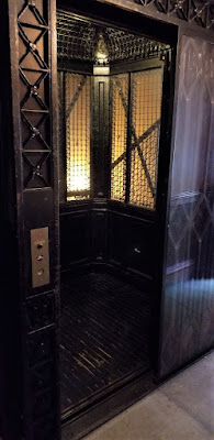
The Biltmore Mansion has four acres of floor space and 250 rooms in the house, including 35 bedrooms for family and guests, 43 bathrooms, 65 fireplaces, 3 kitchens and 19th-century novelties such as an electric Otis elevator, forced-air heating, centrally controlled clocks, fire alarms, and a call bell system.

To the right of the marbled Entrance Hall, the octagonal sunken Winter Garden is surrounded by stone archways with a ceiling of architecturally sculptured wood and multifaceted glass. The centerpiece is a marble and bronze fountain sculpture titled Boy Stealing Geese, created by Karl Bitter.


The Banquet Hall is the largest room in the house, measuring 42 ft × 72 ft (13 m × 22 m), with a 70 ft-high (21 m) barrel-vaulted ceiling. The table could seat 64 guests and is surrounded by rare Flemish tapestries and a triple fireplace that spans one end of the hall. On the opposite end of the hall is an organ gallery that houses a 1916 Skinner pipe organ.


The two-story Library contains over 10,000 volumes in eight languages, reflecting George Vanderbilt's broad interests in classic literature as well as works on art, history, architecture, and gardening. The second-floor balcony is accessed by an ornate walnut spiral staircase. The Baroque detailing of the room is enhanced by the rich walnut paneling and the ceiling painting, The Chariot of Aurora, brought to Biltmore by Vanderbilt from the Palazzo Pisani Moretta in Venice, Italy.


The second floor is accessed by the cantilevered Grand Staircase of 107 steps spiraling around a four-story, wrought-iron chandelier holding 72 light bulbs. The second-floor Living Hall is an extension of the grand staircase as a formal hall and portrait gallery. Several large-scale masterpieces are displayed in the hall.


Located nearby in the south tower is George Vanderbilt's gilded bedroom with furniture designed by Hunt.


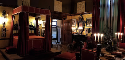
His bedroom connects to his wife's Louis XV-style, oval-shaped bedroom in the north tower through a Jacobean carved oak paneled sitting room with an intricate ceiling.


Fully electric and centrally heated, Biltmore House, at the time of its completion, was considered one of the most technologically advanced structures ever built and is still admired today for its innovative engineering. It used some of Thomas Edison's first light bulbs, boasted a fire alarm system, an electrical call box system for servants, two elevators, elaborate indoor plumbing for all 34 bedrooms and a relatively newfangled invention called the telephone.


The basement level featured activity rooms, including a large muraled room often used for kids as a haunted house during Halloween,...


a two-lane bowling alley,...


an indoor, 70,000-gallon heated swimming pool with underwater lighting,...


and a gymnasium with once state-of-the-art fitness equipment.


The service hub of the house is also found in the largest basement in the U.S. It holds the main kitchen, pastry kitchen, rotisserie kitchen, walk-in refrigerators that provided an early form of mechanical refrigeration, the servants' dining hall, laundry rooms, and additional bedrooms for staff.


One of the two ornate elevators located within the mansion.


Following George’s early death at age 51 in 1914, his wife, Edith, sold a large portion of the original landholding to the government — 87,000 acres — to preserve in a natural forestry state, following his intentions for the acreage. 


Over the next few years, selected properties were sold from the estate, including the Biltmore Village. Today the Biltmore Estate encompasses about 8,000 acres.


Biltmore's unique horticultural environment creates a blooming season that begins in early spring and continues until the first frost: in other words, something is blooming at Biltmore from March through November. Even during winter months, the conservatory is full of colorful tropical plants such as poinsettias, orchids, lilies, cacti and bougainvillea.


After more than two hours of touring the Biltmore Mansion and Gardens, we all drove over to the Biltmore Village. I think the biggest interest there was the winery. The ladies spent much of the time there. Candy purchased a Biltmore wine glass for her two bottles of Biltmore wine.

Before heading home, we stopped at a Greek/Italian restaurant for a late lunch / early dinner. From there it was a drive back to the Lake Norman RV Resort. A great adventure was had today and this time with a group of friends. Until next time...

To follow along on our travels and keep up with my latest blogs, you may do so here of course. But also by using you favorite of these social media platforms: FacebookMeWeGabRedditParlorTwitterRVillageGETTR and Instagram. These all link directly to my profile. Again, please feel free to comment and / or share.

Saturday, January 22, 2022

2020-07-04: Day 2 of Our Roadtrip Through the Smoky Mountains and Finding Fugitive Crash Site and Smallest Post Office

Welcome back friends, Jeepers, Geocachers, RVers, and Adventurers. On this Day 2 of our long weekend roadtrip geocaching through the Smoky Mountains, we got to see the beauty of the mountains while discovering some other sites of interest as well. Such as the bus and train crash scene from the movie "The Fugitive" and the smallest post office in the country. But not to get ahead of myself. So climb aboard the GeoJeep and lets go exploring.


Leaving Morganton, I drove back north towards the Blue Ridge Parkway. Our first stop was just a simple LPC (Light Post Cache)(GCV6EB). It made for a quick stop and credit for Mitchell County. Now usually you'll find just a pill bottle with the logsheet inside under these skirts. But this was a first time for me seeing that the entire skirt was used as the geocache container.


A few miles later over in Yancy County, I made another quick park and grab geocache stop to claim a find in that county (GC18PVC). Continuing on US-19 over into Madison County, we made a stop at the Mars Hill Recreation Park for one more quick geocache (GC5CWVV).

The next one on the list is just another of the many reasons I like Geocaching. In Jackson County, specifically in the town of Dillsboro along the banks of the Tuckasegee River, there's a geocache hidden up above the Fugitive Train Wreck (GC3F9ZA). In the 1993 movie "The Fugitive," starring Harrison Ford and Tommy Lee Jones, included a wreck involving a train and a prison bus. 


This wreck was staged near Dillsboro on a rail siding in the GSMR maintenance yard, between the working rail tracks and Haywood Road, the rail cars and bus remain in the same location today. Year round you can get a good view of the Illinois Dept of Corrections transport bus. But as you can see from our photos, the train is a bit hard to see with all the summertime foliage.


We even drove around to the other side of the river to get a different view, but not much better. The best view of the wreckage would be to take a ride on the Great Smokey Mountain Railroad which runs on the tracks right along side of it.


Driving west on US-64 to Clay County, the most western North Carolina county we needed to complete our map, we target the nearest geocache "The Legend of the Fairy Cross" (GC3GX90). This section of US-64 runs alongside Buck Creek. We exit the highway closer to the geocache onto the parallel National Forest Road, which looks like it might have been the Old US-64.


There was a small pull-off area to get to Buck Creek, so I decided to stop for a moment for some photos. I like these old roads enclosed by bushes and trees. After a few minutes of enjoying the sounds of the creek and taking some photos, we drove up a little further and turned onto Buck Creek Road.


For all my geocaching friends I thought I'd post a rare photo of my GeoJeep. Usually I'll post just the hood logo in front of something or have the tracking code blurred out like in the pic above. I'm only gonna leave this here a week, maybe longer, so log your "Discovered It" soon. I don't normally allow virtual discoveries so please don't copy this photo to your social media sites. And please include the location of where I'm parked in your discovered log. Thanks.

50ATJ9

Now back to the geocache. According to the description on the cache page: "this general area has a great history of minerals and mining. We are aware of at least 4 abandoned mines nearby. One of the minerals unique to the area is staurolite crystals, also known as fairy crosses because of their unique shape.

"Two thousand years ago, so the Cherokee legend of Fairy Crosses begins, the "Yunwi Tsunsdi," or Little People, lived in the beautiful mountains of what is now North Georgia and Western North Carolina. Shy and elusive creatures, the Little People were revered throughout the Cherokee Nation for their ability to find people lost in the thickly forested mountains of the region.

"One evening, while the Little People were enjoying an enchanted celebration of dance, music and song, a foreign messenger arrived bearing the sad news of the Crucifixion of the Son of the Great Creator. So moved were the Little People upon hearing the news of the loss of one so great, that they were moved to tears. As their tears fell to the ground, they turned into Fairy Crosses, where they can be found to this day."

Well I don't know anything about the little people or fairy crosses, but I did find the geocache down by the creek. I looked along the banks a few minutes for some minerals or cool rocks, but I didn't see anything special. Didn't want to spend too much time there though.


Finally rounding the corner and headed back to the east towards the campground, we followed US-64 into Highlands and Cashiers. Once in Highlands, I started taking the rural backroads to my next stop. It was there we found the Smallest U.S. Post Office in the country, at just 6 feet by 6.5 feet.

Originally built in 1878 about a mile away on Whiteside Road next to a grist mill at Sliding Rock, our next stop below. It remained there for 69 years and its first postmasters were Thomas and Elizabeth Grimshawe. In 1911 the Grimshawes sold their property to Warren and Lena Alexander who acted as the postmasters for 36 years. In 1947 they sold their property and the post office was moved near its current location once owned by the Alexander's daughter. Mae Alexander Passmore was postmaster for the final 6 years until President Dwight Eisenhower closed all third class post offices in 1953.


It was then moved and used as a ticket office and post card stand until returning here in 1976. Falling into disrepair and still getting the occasional tourist visitor, in 1999 neighbors decided to restore the post office and move it off the road a little bit and provide safe parking. From the photos displayed inside, the front area where I'm sitting was the customer area and the back half for mail and storage. Currently hanging on the back wall is the last flag which flew over the post office from the 1950's.


Driving a mile up the road we get to Sliding Rock. Actually a waterfall flowing over a large smooth rock, it turns a creek into a natural waterpark. A popular place in the summer time to cool off as you can see. There was a geocache on the short trail leading from the parking area to the rock but I couldn't find it. (The cache has since been archived as many others could not find it as well.)


And finally, one last quick roadside geocache (GC3C0B0) in Transylvania County to complete my final 100 North Carolina counties Geocaching map!

That was it for Day #2 of our long holiday weekend. On Day #3, Candy wasn't feeling well and we drove nonstop back to the campground at Lake Norman. I hope you have enjoyed this roadtrip through the Smoky Mountains. And perhaps found something I've written about to add to your bucket list of places to visit. See you back real soon.

To follow along on our travels and keep up with my latest blogs, you may do so here of course. But also by using you favorite of these social media platforms: FacebookMeWeGabRedditParlorTwitterRVillageGETTR and Instagram. These all link directly to my profile. Again, please feel free to comment and / or share.

Saturday, January 15, 2022

2020-07-03: A Long Weekend Geocaching Counties and Hiking in Western North Carolina

Well we're working in North Carolina and have a 3-day holiday weekend. Do we chill at the RV Park or go exploring the Smoky Mountains and Geocache the remaining six counties to complete the state? It's a roadtrip of course! Grab the hiking boots, hop into the GeoJeep, and let's go sightseeing along the backroads of North Carolina!


Leaving the Lake Norman Motorcoach Resort behind for a few days, we headed west on NC Highway 18 until we got near Pleasant Grove. There we made a detour over to a bridge on Old North Carolina 18 for a First-to-Find attempt at a geocache published two days earlier (GC8VWYF). Another geocacher tried to find it the same day it was published without any success. I tried searching for nearly 30 minutes. But it wasn't for me to find on this day. I ended up having to log a DNF.

Driving north on US-321, I get off at the Mulberry exit for our next geocache (GC8MRYY). It was located near Silvervale Falls. These cascading falls are about 80 feet from top to bottom. Being this far from the Blue Ridge Parkway, there aren't as many tourists visiting these waterfalls. Only enough parking for 3 cars and we didn't have any problem. But worth the stop if you happen to be nearby.


One of the other reasons I like geocaching and traveling the backroads is that you never know what you might come across. Like this old rusty car, truck, and tractors lined up on the side of the road. I just had to stop and get a few photos.


Our next stop WAS to be Blowing Rock and then Grandfather Mountain. I've visited the Smokey Mountains and the Blue Ridge Parkway many times. However I have never made it to these two popular tourist destinations. Today it was going to be another of those times. It was July 4th weekend and the places were packed full and we did not want to contend with the crowds. So we continued on southbound down the Blue Ridge Parkway.

One of the first photo opp stops we took along the parkway was at the Wilson Creek Valley Overlook. A great view and you can see for miles!


Our next stop was a hike for a virtual geocache in the Linville Gorge Wilderness Area. The Linville Gorge Wilderness is part of the Pisgah National Forest. The gorge is formed by the Jonas Ridge on the east and Linville Mountain on the west and is bisected by the Linville River which drops 2,000 feet into the valleys below.

The virtual geocache (GC3A44) was a hike down the Spence Ridge Trailhead. This trail was supposed to take us down to the Linville River where we were to find the "House Rock," a flat top rock formation in the river that looks like a house. I wish I could show a picture of it, but we never made it. After about an hour of hiking, we were slowly getting closer but the destination appeared to be staying off to the right. Finally we decided to turn around and head back to the GeoJeep. As we were hiking back I noticed the correct trail we should have stayed on teeing off. Oh well, maybe next time.


Driving our way around to the other side of the Linville River we headed for our next virtual geocache called "Look At That" (GCG9YT). After 3.5 miles of gravel road, a little rough in a few spots, we made it to our destination at the Wiseman's View Scenic Overlook. Just a short walk from the parking area and you'll arrive at this viewing platform high above the gorge.


Driving back along the 3.5 mile gravel road, which is the Old NC 105 / CR 1238, I spotted this old road marker off the side in the weeds. After a few hours of research, Andrew Milton Kistler (1871-1931) was originally from Pennsylvania and became a prominent businessman in Morganton, Burke County, NC. First established in 1926 as the primary route between Nebo and Linville Falls, a 24 mile road that has since been rerouted and improved. The remaining Old NC 105 is now 17 miles of gravel road which can require 4x4 in some areas. That just added to the adventure in the GeoJeep.


We ended the day in Marion, NC. It was a pretty good day with the sightseeing, the hiking, the off-roading, and a little bit of history. I hope you have enjoyed todays adventure. See you back soon for another day of exploring the Smoky Mountains in Western North Carolina.

To follow along on our travels and keep up with my latest blogs, you may do so here of course. But also by using you favorite of these social media platforms: FacebookMeWeGabRedditParlorTwitterRVillageGETTR and Instagram. These all link directly to my profile. Again, please feel free to comment and / or share.

Saturday, January 1, 2022

2020-06-20: Taking a Trip Back to Mayberry and Andy Griffith's Hometown of Mount Airy, North Carolina

Welcome back friends, family, fellow traveler's, Geocachers, Jeepers, RV'ers, and ALL of you who've stopped by our AwayWeGo's Geocaching Adventures Blog. We're a couple of work travelers in construction and our job takes us all over the country. Currently, we're on a project in Central North Carolina near the town of Maiden.

Today was a great day to take a roadtrip back to Mayberry (GCJF95). Many say that "The Andy Griffith Show" was based on Mount Airy, NC, Andy's birthplace. So let's go for a drive and see what they've done to the town.

Mount Airy was settled in the 1750s as a stagecoach stop on the road between Winston-Salem, North Carolina and Galax, Virginia. It was named for a nearby plantation. Mount Airy was incorporated in 1885. The City's official seal was established in 1977, which depicts major industries that are home to Mount Airy including: furniture, textiles, and the granite quarry. In 1994, Mount Airy was named an All American City.


The Andy Griffith Show aired eight seasons on CBS from October 3, 1960, to April 1, 1968. The series originated partly from a prior episode of The Danny Thomas Show. The show stars Andy Griffith as Andy Taylor, the widowed sheriff of Mayberry, North Carolina, a fictional community loosely based on Mount Airy. Other major characters include Andy's cousin, the well-meaning and enthusiastic deputy, Barney Fife; Andy's aunt and housekeeper, Bee Taylor; and Andy's young son, Opie. Griffith said that the show evoked nostalgia, saying though it was shot in the '60s, it had a feeling of the '30s. It was, when we were doing it, of a time gone by."


Griffith was born on June 1, 1926, in Mount Airy, North Carolina, the only child of Carl Lee Griffith and his wife, Geneva. As a baby, Griffith lived with relatives until his parents could afford to buy a home. With neither a crib nor a bed, he slept in dresser drawers for several months. In 1929, when Griffith was three, his father began working as a helper or carpenter and purchased the home pictured below in Mount Airy's "blue-collar" south side. Griffith grew up listening to music. By the time he entered school, he was well aware that he was from what many considered the "wrong side of the tracks". He was a shy student, but once he found a way to make his peers laugh, he began to come out of his shell and come into his own.


The Mayberry Courthouse is a replica of the courthouse that appeared in “The Andy Griffith Show” during the 1960s. Situated adjacent to Wally’s Service Station, visitors can sit behind Andy’s desk, type on the vintage typewriter, and even sit in the recreated jail cells that appeared in the show.


Remember Sheriff Taylor’s police car? The one you saw in every episode? In Mount Airy, you can tour all of the sites in a Mayberry squad car. Each tour starts at Wally’s Service Station, then it will travel up and down the streets of Mount Airy. Wally’s Service Station is an original service station built in 1937 and operated as a Gulf Station and then later operated as a Standard Oil Station or Esso.


As a student at Mayberry Union High (Mount Airy High School), Griffith cultivated an interest in the arts, and he participated in the school's drama program. A growing love of music, particularly swing, would change his life. Griffith was raised Baptist and looked up to Ed Mickey, a minister at Grace Moravian Church, who led the brass band and taught him to sing and play the trombone. Mickey nurtured Griffith's talent throughout high school until graduation in 1944.


The Darlings (usually pronounced "Darlin's") lived in a mountain shack, like the one below behind Wally's Garage, somewhere in the mountains neighboring Mayberry. The good-natured, but trouble-making Appalachian clan, led by patriarch Briscoe Darling (played by Denver Pyle) usually came into town piled into the back of their old truck.


Though Methodists had been present in Surry County since the 18th century along with Baptists, Moravians, Quakers, and other religious groups, the original Methodist church in town was established only in 1831. The “Old Methodist” cemetery belonged to Mount Airy’s Methodist Episcopal Church, South, after part of the 1831 Lebanon congregation moved to a new location on South Main Street in 1858. The cemetery and church were built on land donated from Elisha Banner’s plantation, and the earliest burial dates back to 1857.


Local tradition says that the church’s bell, now housed in Trinity Episcopal’s belfry, tolled during funerals for every year of the deceased’s life. The cemetery acted as a town cemetery, not just for one for Methodists, and it was replaced by Oakdale Cemetery in 1892 when space began to run out. The church changed its name to Central United Methodist Church when it moved closer to the center of town in the 1890s, and the last burials at the Old Methodist Cemetery (GC4NZNT) were made around the turn of the century.


Leaving Mayberry, we drove down the highway on the way back but not before hiking Mount Pilot. Pilot Mountain was the inspiration for the fictional town of Mount Pilot in “The Andy Griffith Show.” Nearby the actual town is Pilot Mount State Park (GC88Z1Y) which is known for its Big Pinnacle peak seen for several miles. It was a nice short hike over to the observation deck where I got this great wide angle photo.


That was our return to Mayberry. It's one of those must visit towns if you're a fan of the of the TV show.

To follow along on our travels and keep up with my latest blogs, you may do so here of course. But also by using you favorite of these social media platforms: FacebookMeWeGabRedditParlorTwitterRVillageGETTR and Instagram. These all link directly to my profile. Again, please feel free to comment and / or share.

Friday, November 26, 2021

2020-06-04: More Geocaching Through the Backroads of Georgia Counties and a Confederate P.O.W. Camp

So on this second day of our roadtrip through the backroads of Georgia, on our way to North Carolina, we still didn't get very far. After nine hours we've barely gone 200 miles from where we started this morning. Also, we only managed to find 6 geocaches located in 4 new geocaching counties. However we did find a 20 year old geocache that was hidden way back in June 2000! There were a lot of cool historical sites on the agenda today. Let's go for a drive and do some sightseeing...


Our first stop was a virtual geocache (GCGMJY) in Andersonville, Georgia. The Andersonville National Historic Site began as a stockade built about 18 months before the end of the Civil War to hold Union Army prisoners captured by Confederate soldiers. This location became the deadliest ground of the Civil War. Nearly 13,000 men died on these grounds.


Located deep behind Confederate lines, the 26.5-acre Camp Sumter (named for the south Georgia county it occupied) was designed for a maximum of 10,000 prisoners. At its most crowded, it held more than 32,000 men, many of them wounded and starving, in horrific conditions with rampant disease, contaminated water, and only minimal shelter from the blazing sun and the chilling winter rain. In the prison's 14 months of existence, some 52,000 Union prisoners arrived here; of those, 12,920 died and were buried in a cemetery created just outside the prison walls. Conditions were so bad here that the residents of the town of Americus, 10 miles to the south, often complained of the smell blowing in their direction.


The stockade was designed in this location with the theory that a small creek passing through the middle would provide fresh drinking water upstream as it entered at the higher elevation. The lower elevation would be used as a latrine downstream and flush sewage out as the water flow exited the camp. Inadvertently, the prison was designed for death. Stockade posts slowed the drainage, and during dry spells the creek was more of a stagnant swamp than flowing stream. Dysentery swept through the camp. Overcrowding soon fouled the water, and the sluggish current failed to wash sewage out of the prison. The stream's bacteria quickly became lethal.


Today, Andersonville National Historic Site comprises three distinct components: the former site of Camp Sumter military prison; the Andersonville National Cemetery, where veterans continue to be buried today; and the National Prisoner of War Museum, which opened in 1998, and serves as a memorial to all American prisoners of war.


The cemetery site serving Camp Sumter was established as Andersonville National Cemetery on July 26, 1865. By 1868, the cemetery held the remains of more than 13,800 Union soldiers whose bodies had been retrieved after their deaths in hospitals, battles, or prison camps throughout the region. Andersonville National Cemetery has been used continuously since its founding and currently averages over 150 burials a year. The cemetery and associated prison site became a unit of the National Park System in 1970.


These six graves were deliberately set apart among the others. These six prisoners were buried with dishonor. Only enlisted soldiers were held at Andersonville. With no Union officers to maintain order, life in the pen became anarchy. A gang known as the Raiders roamed the prison yard, bullying, robbing, and even murdering other prisoners. Eventually, with the blessing of Commandant Wirz, the prisoners formed a police squad called the Regulators and arrested the Raiders. Before their execution, the six Raider leaders were court-martialed by their peers. Confederates provided lumber for the gallows, which was erected near the prison's South Gate. The remaining Raiders were forced to run a gauntlet formed by their fellow prisoners.


After nearly 2 hours of wandering the grounds, looking at all the large state monuments and memorials, the stockade walls, displays and information boards, and just taking it all in, it was time to get back on the road.

From there we went to another historical virtual geocache (GCGVRY). The town of Americus, Georgia plays a part in aviation history. From the statue and historical marker at the Jimmy Carter Regional Airport: "The "Lone Eagle" first flew solo in early May, 1923 from Souther Field. Charles Lindbergh had come to Americus to purchase a surplus aircraft from the World War I training center. He chose a Curtiss JN4 "Jenny." He got the plane with a brand new OX-5 engine, a fresh coat of olive drab dope, and an extra 20 gallon fuel tank for $500. Lindbergh had less than 20 hours of instruction when he soloed. He practiced take-offs and landings for a week; then having filled up with 40 gallons of gas, he set course for Montgomery, Alabama, to start his barnstorming career. Four years later Lindbergh flew alone in "The Spirit of St Louis" from New York to Paris and into aviation history."


Next door at the South Georgia Technical College was our next cache (GC17V02). The land on which the college now sits was once a training facility for WWI and WWII pilots. This is also the where Charles Lindbergh trained and had his first solo flight. It was converted to a college in the late 1940's. This was one of the airplanes located on the campus grounds.


Over in Crawford County in the town of Knoxville, Georgia more history was to be found. My next two geocaches were located by the old courthouse (GC6C5C, GC3DFJG). Crawford County was created by Acts of the Legislature on Dec 9 & 23, 1822, and is named for William H. Crawford, a Georgia statesman. This building served as the county courthouse from 1823 until a new one was constructed in 2001.


Most everyone has heard of Route 66, the Lincoln Highway, and many other historic highways which played a role in the expansion of this country. US-80/GA-22 passing through town was once known as the Federal Wire Road. This highway, created by an Act of Congress in 1810, entered the state at Augusta, passing through Warrenton, Sparta, Milledgeville, Macon and Knoxville to Coweta Town (now called Columbus). It was formally known as the Stage Coach Road. A telegraph line, the first that connected New Orleans with Washington D.C., was erected in 1848. The wires paralleled this road between Columbus and Macon giving to this section of the old highway the name of the Federal Wire Road. This telegraph line was also the first one to be erected in the state of Georgia.

Knoxville also played a role in Texas history. It was here that Joanne Troutman gave to a company of Georgia soldiers commanded by Col. William Ward on their way to fight for the Independence of Texas, a Lone Star Flag. It was carried to Goliad where James Fannin Jr raised it as the Texas National Flag.

One more that I want to mention... Alexis de Tocqueville, the 25 year old French aristocrat and author of Democracy in America, visited this area during his 1831-1832 tour of America.

Over in Jones County we stop at a park for short hike to our next geocache (GC229DF). The first iron foundry in Georgia was established here by Samuel Griswold, who came from Connecticut, settling in Clinton in 1820. He also manufactured about 1,000 cotton gins a year and ran a steam sawmill and grist mill. Moving to Griswoldville in 1849 to be on the railroad his mansion and factories were burned by Sherman in 1864 when he was making pistols and ammunition for the Confederacy. He died in 1867. Daniel Pratt of Temple, NH, later designer of the Alabama capitol, was at one time Griswold's partner.


Moving right along we made a quick roadside stop for a quick cache in Jasper County (GC5RKVD).

Looping around Atlanta to the northeast side, we arrive at our final geocache of the day. This is one that has been on my bucket list for a long time. Beaver Cache (GC1D) was hidden way back in June 2000 and is the 8th oldest active geocache in the world. I had been close to it many times before, but either didn't have the time or just forgot all about it. That completes one more of my Year 2000 calendar. All that's left now is July and August.


So that was Day 2 of our Florida to North Carolina roadtrip. Like I said at the beginning, we saw a lot but didn't get very far.

On Day 3 it was just driving straight through the rest of the way where we reached our destination at the Lake Norman Motorcoach Resort. For the next few months here working at this project, this will be home:


Come back soon as we will be exploring the backroads of North Carolina and completing the last 7 NC Counties while we're here.

To follow along on our travels and keep up with my latest blogs, you may do so here of course. But also by using you favorite of these social media platforms: FacebookMeWeGabRedditParlorTwitterRVillageGETTR and Instagram. These all link directly to my profile. Again, please feel free to comment and / or share.