Showing posts with label chapel. Show all posts

Saturday, March 13, 2021

2019-05-26: Roadtrip Day2! The North Carolina County Challenge: Visiting Mt Pilot, Siamese Twins, the Jail Chapel, and the Blue Ridge Parkway

Rise and shine roadtrippers, geocachers, travelers, and friends. Today is Day 2 of our 3-day Memorial Day weekend roadtrip across North Carolina. (Click here for Day 1) We gotta lot of miles west into the mountains to get to today. And hopefully round the corner back east to start the return trip for tomorrow. So grab a cup of coffee, climb into the GeoJeep and let's get going...

I grab breakfast in the lobby and check out of the hotel at the crack of dawn. Before driving away, I first grab the geocache (GCW6C1) in the parking lot to claim a find for Forsyth County. It wasn't a planned cache, but when there's a geocache so close it's hard to just leave it behind.

Driving west into Yadkin County, I pass through East Bend headed for the Mt Olympus Greek Restaurant for my next geocache (GC42WQF). What should have been a quick parking lot find turned into 15 minutes spent for a DNF. Being half Greek, I really wanted to find this one. But no luck this morning. I still need the county so I drive another mile down the road for another quick roadside cache and find that one (GC3YNZM).

On the way to my next geocache, driving the backroads through the country, I spot this old truck sitting off to the side of this gated driveway. Then I notice the skeleton sitting inside and just knew I had to turn around for a photo. As I'm taking the photo, I see the sign and realized that I'm getting my picture taken also.


Driving north on US-52 into Surry County, I see my next goal. As a fan of "The Andy Griffith Show" I wanted to return to Pilot Mountain, also known as Mt Pilot on the TV show. It's been nearly 14 years since I last visited this area with my sons and I hadn't yet started geocaching. There were two geocaches: "This Way to Pilot Mountain" (GC322YP) near the state park entrance and the "Pilot Mountain" Earthcache (GC1195C) up near the observation deck. I drove up the mountain to the parking area and made the short hike to the observation deck. After some photos I gathered the information I needed to claim a find for the earthcache.

Driving up US-52 with a view of Pilot Mountain

The view from the observation deck.

The view from the observation deck.

I wouldn't want to be down below if that rock slides off!

Instead of continuing on up to Mayberry (Mt Airy), since I've been there before, I thought I would check out less popular historical sites. Such as a virtual geocache at the grave of the Bunker Brothers (GCF338). I know... you're probably thinking "Who are the Bunker Brothers?" More commonly known as the Siamese Twins, Chang and Eng were born in 1811 in what used to be called Siam, now Thailand.

In 1829, the twins left Siam to begin touring Europe and the US. They were very popular and drew large crowds in "freak shows" where the twins exhibited various feats of strength and dexterity. In 1839 the brothers quit touring, purchased 150 acres in Traphill, became American citizens and choose the last name of Bunker in honor of a woman they met and admired in New York. In 1845 they purchased 650 acres here in Surry County. A few years later the twins married two sisters, Sallie and Adelaide Yates


Within 9 months and one week of the marriage each sister had given birth to a child. Over the years 19 more children would be born to the sisters. Over time, the two sisters began to fight and would often put Chang and Eng in the middle of their fights. It was decided that the family would split and two houses were built. The two houses were about two miles apart and the twins would spend three days in one house with Sallie and then move in with Adelaide for three days before starting the cycle all over.

Chang passed away on Jan 17, 1874. There were several theories and autopsies performed as to why Eng died, some saying within 30 minutes and others up to two hours. It is often said that Eng was scared to death of the thoughts of his brother being dead and have attributed his death to shock. Others concluding that blood continued transferring from Eng to Chang, but obviously not returning. They were then buried in the lawn at Chang’s house and in the 1920’s were moved to the church that they are at now, which the brothers had donated the land for.


The White Plains Baptist Church was established in 1856 on land donated by Chang and Eng who went to church there. The twins, their wives, and 40 other Bunker's are buried there in the cemetery, plus many other descendants under various other names.

One more geocache for Surry County was at the Dix Freeman Homeplace (GC4P3ER), a favorite location for Round Peak musicians to gather to play their old-time music and hold weekly square dances. Furniture would be moved, sometimes even outdoors, to make room for two or more groups of square dancers in the two room cabin. String musicians, mostly fiddle and banjo players, would stand in the doorways and play their music for the dancers.

“Breaking up Christmas,” usually held after harvest time between Christmas and the New Year, was a time for festivities including music, dancing, socializing and lots and lots of food! Families in this Round Peak area would begin at the Freeman home and then travel to a different cabin every night. Dix Freeman, 1908 – 1995, was an oldtime claw-hammer banjo player who learned to play when he was 10 years old. He credits learning most of his banjo tunes from the legendary Charlie Lowe. Dix played with the Pine Ridge Boys and was a collector of banjos and fiddles, amassing over 237 instruments.

Round Peak Mountain, eleven miles east of here, lends its name to the signature style of old-time fiddle and banjo music that developed in its shadow. The relative isolation of the community and difficulty of travel during most of its history helped to ensure that a limited selection of songs shared and composed by residents would eventually became the core of today’s “Round Peak” music. Round Peak music is characterized by a close interplay between the fiddle and the “fretless” banjo with a driving sound that developed as the musicians played for flat foot and square dancers at frequent social gatherings such as corn shuckings, barn raisings, house parties, and an annual local party tradition referred to as "Breaking Up Christmas."


Moving right along and hopefully picking up the pace. I found a quick roadside geocache in Alleghany County (GC2RTZF) before getting onto the Blue Ridge Parkway. Then quick earthcaches at the Stone Mountain Overlook (GC77NWW) and the Air Bellows Gap Overlook (GC6TP4K).


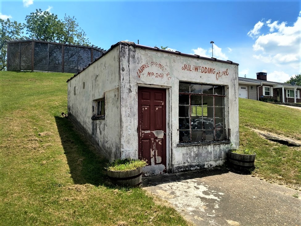
One more stop further down the parkway exiting at mile marker 248 was for a cache (GC47JGV) at this Jail / Wedding Chapel in Laurel Springs. Gives new meaning to the term "shotgun wedding" I suppose. Doing a little research, I found that that wasn't ever a real jail or chapel. Just painted up that way for a roadside attraction and photo opp. Unfortunately it was a busy area off the parkway with a restaurant and bar across the street and a motel and campground nearby. There were a lot of muggles nearby and made it difficult to search for the cache.


Driving down to Glendale Springs in Ashe County, I stop for a multi-cache. A multi-cache is where you have to go to multiple stages getting clues to the final coordinates. They can be as few as a simple 2-stage cache to as many as you want. I think the longest I've found was a 7- or 8-stage multi-cache.

This one was called "Re-Visit the Past" (GCK8FB). In the late 1800’s Episcopal missionaries came to this region of the Blue Ridge Mountains to provide schooling and medical help for the people living there. Holy Trinity Episcopal Church was built in Glendale Springs in 1901. After the church was officially closed in 1946, members began removing the furnishings and taking them home. For over 30 years the church sat deserted and neglected. In 1972, Rev. Faulton Hodge became priest-in-charge at St. Mary’s Episcopal Church in nearby West Jefferson. In the late 1970’s, he started a campaign to restore Holy Trinity. As work progressed on the building, the original furnishings were returned. Today the church has its original pews, pump organ, Altar, and candle stands.

There's also a cemetery on the property as well that has over 200 interments and is still in use today. According to the findagrave website, the oldest dates back to 1879. After gathering clues from the front and cemetery area, The final cache location was around back by this large statue.


Then there is the "Fast Find" cache (GC5QYT7) in Watauga County followed by another quick roadside stop at "Fall Creek" guardrail cache (GC29P3N) in Wilkes County. Had to take a few pictures at the creek though.


Getting back to the Blue Ridge Parkway southbound, I stop at the Green Mountain Overlook for another earthcache (GC6YHXZ) in Caldwell County and a few photos. I decided to include the GeoJeep in one of them.


Moving down into Avery County there was the Boulderdash Earthcache (GC700KY)...


...followed just down the road by the Artic Window Peak earthcache (GC21N6F) at the Yonahlossee Overlook.


My next stop was down in McDowell County at a cache called Restful River (GC6KHW5). This cache was near the bridge overpass for the North Fork Catawba River and the Honeycutt Creek. Down along the banks were a dozen or more of these butterflies. Every now and then they'd stop long enough for me to get a photo.


And then there's the "Be In Three Places At Once" cache (GC6HE12). Louise's Rock House Restaurant was formerly known as the Linville Falls Tavern and is on the National Register of Historic Places. Built in 1936 by stone mason Lenoir Franklin and owned by C.J. Howell, the tavern was built right where the intersection of three counties converge. The Avery, Burke, and McDowell counties all come together near the fireplace. With the layout of the restaurant, your food is cooked in Avery County, picked up by the wait staff in Burke County, and then served to you in McDowell County. Even though the restaurant was a little busy, the cache was hidden enough by the wall that I was able to quickly retrieve it without being seen. I just forgot to take photos.

Well it was starting to get late in the day. Looks like I'm gonna have to skip a few of the counties still to west and round the corner back towards Blounts Bay. So I head south into Rutherford County and the town of Forest City. There I get a quick parking lot cache (GC4H1H9) to claim that county. Now driving on US-74 eastbound, another quick parking lot cache in Cleveland County (GC16C21). Turning north on US-321 for a park and grab in Lincoln County (GC53CBQ).

Saturday, January 23, 2021

2019-05-03: Moving Day Roadtrip from Texas to North Carolina Day 1 in TX, LA, & MS Cemeteries, Historical Sites and an Old Church

Well it's that time again. I finished up on the wind farm down in South Texas and have to be in North Carolina on Monday to start a solar project. So another roadtrip is ahead of me. Supposed to be 2-3 months there in NC. Unfortunately the wife will still be here in Texas working. But hopefully the time will pass quickly and the next project will be back in Texas. But for now, lets hit the road and see what kinda cool places we can find.


My first stop, after Duncan Donuts for iced coffee and a bagel of course, was just outside of Waco, Texas. "Sleepy Hollow" (GC3D0BB) was a cemetery and the location of a geocache. Unlike the typical cemeteries I visit, this one is a pet cemetery! I think I've only encountered maybe one or two pet cemeteries before. This one had a doghouse and a fire hydrant as headstones. One thing I didn't see were any zombie cats or dogs that have been resurrected!


Also a little further east outside of Waco was the "Shootout at the Double EE" (GCGM3X) Ranch Road is a virtual geocache. On April 19, 1993, the FBI and ATF raided the compound of the Branch Davidian Church. After 100 canisters of tear gas being deployed over a 6 hour period, a fire broke out and the compound was engulfed in flames. David Koresh and 75 of his followers, including 25 children, perished in the blaze. Only nine managed to escape. The church has since been rebuilt.


My next two geocaches are in Corsicana, Texas at the Oakwood Cemetery (GC3EXG7, GC4G8EJ). There are nearly 14,000 burials dating back to 1833. There are several historical markers throughout the cemetery as well. One of the caches highlights a native of Huntsville, Texas, Samuel R. Frost grew up in Navarro County and in 1863 enlisted in the Confederate army. After the Civil War, he studied law and was admitted to the bar in 1870. In the years that followed, Frost served as Navarro County attorney, county judge, district judge, and state legislator. He and his wife, Mary (Winkler), were the parents of nine children. The town of Frost (20 mi. W) was named in his honor.

Another interment, and a more recent one, is Aaron Dale Allston (1960-2014). He is the author of 13 Star Wars novels as well as many other science fiction, game based fiction and mystery novels, short stories and technical guides for writers.

But the one historical marker that caught my attention was by the grave of David Reed Mitchell. Like myself, he was also a surveyor. From the historical marker: "Born in 1797 in North Carolina, arrived in Robertson County, Texas in 1845. He was a surveyor by trade, and had surveyed the upper Trinity and Brazos river areas in 1844. He became surveyor of the Robertson County land district, as well as the original land of Navarro County and Corsicana.

Mitchell was also a land speculator of sorts, and by 1847 he owned a large amount of land in Navarro County. With two partners, Thomas I. Smith and James C. Neill, he donated one hundred acres on which the town of Corsicana was founded. For a time he operated an inn in the town, sometimes referred to as the "lower hotel" because of its location in proximity to another hotel run by pioneer Hampton McKinney.

David Reed Mitchell married Mary Ann Higgins, and they were the parents of five children. Mitchell continued to live in Corsicana until his death on Oct. 7, 1853. He was buried in Oakwood Cemetery, and the citizens of Corsicana erected a monument at his grave in 1899. Of the three partners who donated land for the city of Corsicana, Mitchell is the only one buried here."


Before leaving Corsicana, I had to stop and get one more geocache here. "The Fruitcake Factory" (GCF11B) is located at the Collin Street Bakery. Yes, that dreaded fruitcake that usually makes an appearance around the Christmas holidays. The Collin Street Bakery is the largest producer of fruitcake in the world. They have been baking since 1896 and are shipping to almost 200 countries around the globe.


Another goal of this roadtrip is to pickup new geocaching counties. I've already completed my Texas counties. Now that I've crossed over into Louisiana it's time to pick off a few more of those. Bienville Parish was the first one with a quick roadside park and grab geocache (GC5BQVX).

My next geocache and county was in Quachta Parish in the town of Calhoun. "Breaker 19" (GC1V79Q) was a creative cache at a CB shop. I posted a photo below and also my first attempt at bringing you a video. Hopefully it works.


Just up the street in Calhoun was the Mount Zion Cemetery. There wasn't a geocache there, but it's still hard to pass up an old cemetery. There are over 500 interments that date all the way back to 1852 belonging to an eight year old boy named Robert Simmons Gaston who died in 1852 while visiting this country with his mother.


Located in Richland Parish, Holly Ridge was established in the early 1900's as a sawmill town in the middle of a large farming area. The company started with making barrel heads and later changed to the lumber industry. The company that owned all the timber land was Chess and Wymond out of New York state. Mr. Franklin leased all the land and cut all the timber. After the timber was gone it became a large farming area owned by the Franklin family. A quick roadside geocache (GC29MH5) in Holly Ridge off of I-20 to claim that county. Some dark clouds overhead isn't very promising though. I did get some heavy rain along the Louisiana / Mississippi state line.


After the rain and crossing over into the state of Mississippi, I jump off of I-20 and drive up into Madison County and the town of Annandale. There I find my next virtual geocache at the Chapel of the Cross (GC29MH5). After John and Margaret Johnstone arrived in Mississippi from North Carolina in 1840, they lost two of their sons that same year and buried them on their land, which would become the Annandale Plantation. John had the idea to build the chapel but died in 1848 before he accomplished it. The Gothic Revival chapel was erected in the 1850's by his wife Margaret L. Johnstone as a memorial to her husband.


Behind the chapel is the cemetery which now contain over 250 interments, the oldest being the two sons from 1840. The geocache page mentions one grave in particular as a question from which you need to answer in order to claim credit for the virtual geocache. But it doesn't give you the history of the grave. Henry Grey Vick was killed in a duel at age 23, just days before he was to marry Helen Johnstone, the daughter of John and Margaret. Helen was said to have worn her wedding dress to Henry's funeral. And legend has it that the "Bride of Annandale" continued to love Henry the rest of her life, even after marrying George Harris, and that her ghost is often seen sitting on a bench near Henry's grave.


Now that the sun is down and it's dark out, my plan is to keep going as long as I can find the geocaches. If I can't find a cache and need the county, then it's time to find a hotel and wait for daylight.

But next up is another virtual cache in Canton, MS. "Casey's Intended Destination" (GCF5FE) was located at the old train depot, now a museum. Canton was the destination of the famous train engineer John Luther "Casey" Jones when his train derailed after colliding with a stalled freight train 15 miles up track. He was traveling at about 75 MPH when he noticed the broken down train cars still on the track about 300 feet ahead near a side track switch.

While he could have jumped off the engine to save his live, as did the fireman on board, he stayed with the engine pulling on the brake and reversing throttle to protect those on the ground and passengers of the other train. He managed to slow down to approximately 35 MPH before colliding with the caboose and 3 of the freight cars when his train derailed. He died upon impact and time was recorded at 3:52 AM by his cracked watch.

I would liked to have gotten some more photos of the outside and down the side with the tracks in view. It was lit up enough. But there were some shady characters hanging out across the tracks on this Friday night. So a quick photo of what I needed for answers and moved on. (answer covered)


From here to the Alabama state line, I found several quick parking lot geocaches in Leake County (GC3CMVJ), Neshoba County (GCV8ZT), and Kemper County (GC7KCNW). Then I continued over into Alabama where I already had the next  few counties. Getting close to midnight I found a hotel in Birmingham for the night.

A long drive today, but I did get to pick up some new counties and see some great places. I especially like that old chapel in Mississippi and wish I got there just a little earlier to get some better photos.

Anyway, tomorrow is another day and another adventure. Do I make it all the way to NC or stop short. Guess you'll have to come back to find out. See you next time...

Saturday, January 2, 2021

Beyond the Alamo, Exploring the Other Four Historic Spanish Missions in San Antonio Texas

Hello friends, travelers, explorers, and geocachers. Welcome back to AwayWeGo's Geocaching Adventures blog. For today's roadtrip, we are going back to San Antonio for a trip back into early Spanish history in North America.

Let's start with a little background. Between 1528 and 1535, Spain sent Álvar Núñez Cabeza de Vaca across the land eventually known as Texas to explore and further claim the region as Spanish Territory. Over the later years, the focus was more to the south. Then in the 1680's with the French starting to intrude from their territory to the east, Spain once again initiated explorers into Texas. In 1686, Alonzo de León led the first land expedition or entrada seeking to expel the French from their colony at Fort St. Louis.

During his fifth expedition in 1690, de León and his chaplain, Fray Damián Mazanet, founded the first Spanish mission in Texas along the Neches River in east Texas. Their successful expedition along the Camino Real Trail created the emergence of San Antonio as a stop for travelers in route from Mexico to East Texas. The first governor of the Province of Tejas, Domingo Terán de los Ríos, undertook another entrada. The Spanish government authorized additional missions among the East Texas Indians. Governor Terán was accompanied by Fray Mazanet and followed the same route as de León before veering further north and passing through the vicinity of present day San Antonio. The two men were the first to visit and name the location.


Under direction of a new governor, Martín de Alarcón in 1718, a new entrada specifically to establish a mission and presidio on the San Antonio River and to deliver supplies to the missions in east Texas began. Because of its location halfway between Spain’s missions and settlements along the Rio Grande River and in East Texas along the French Territory, San Antonio became an important outpost.

The first and most popular of these is the Mission San Antonio de Valero (Alamo) founded in 1718 by Fray Antonio de Olivares. The mission was originally established along the banks of San Pedro Creek but was soon relocated to the east bank of the San Antonio River. After a hurricane destroyed the complex in 1724, it was relocated to its current and final location. Construction began on a stone church in 1744 but it collapsed before it could be finished. Work on a third church, the one that exists today, began around 1756.

Now we all "Remember the Alamo" and its role in the Texas War of Independence. Today it receives more than 2 1/2 million tourists a year visiting from around the world. Many of those also visiting the San Antonio Riverwalk and its many shops and restaurants between The Alamo and the 1730's San Fernando Cathedral Catholic Church. You can read more about our visit to these sites in a previous blog here.

Now we get to the main reason of todays return trip to San Antonio. Most tourists don't even realize that there are a total of five Spanish missions in San Antonio just a few miles apart. There is a walking / biking trail to connect them to the main Riverwalk. However, we decided to drive between them.


Our first stop was at the Mission San Francisco de la Espada. Originally established in 1690 in East Texas, it is one of three missions relocated to San Antonio in 1731. Since water was vital to the mission and survival of the community, the Franciscan Missionaries and their Indian followers built a dam, irrigation ditch, and aqueduct from 1740 to 1745, after laying the foundations of the mission but before the construction of permanent buildings on site.


The vast walled complex consisted of the church building, the two-story priests quarters, workshops, storage facility, a friary, and Indian quarters surrounding an open courtyard. The stone rooms which served as the Indian housing were built along inside the fortified wall. By 1762 three sides were lined with these houses.


Then we drove over to the Mission San Juan Capistrano. Like Mission Espada, it was also relocated to San Antonio in 1731. In addition to its early history, the mission compound itself was constructed in a similar form, including a church and plaza surrounded by a defensive wall formed from stone Indian quarters. By 1756, the mission’s first church was completed in addition to a convent building and a stone granary.


By 1762, a second church building was under construction, though the Native American converts were still living in temporary jacal type housing. Mission San Juan was never as successful as its counterparts. One reason was that the Spanish government did not allot the mission sufficient lands to cultivate food and to engage in ranching activities. The mission was also subject to repeated Apache raids, which reportedly occurred more frequently there than at other missions.


Next up was the Mission San José y San Miguel de Aguayo, founded by Father Antonio Margil de Jesus in 1720. Approval for its construction was granted in order to serve several Native American groups who would not settle at Mission San Antonio de Valero (the Alamo) because they refused to live with other Native American groups already residing there. As with the other missions, the primary goal of the Spanish missionaries at Mission San José was to convert local Native American groups to Christianity and to assimilate them into Spanish society.


Approximately 240 Native individuals were assigned to the mission upon its commission, but a deadly epidemic dramatically reduced the Indian population to 41 by 1739. Many different groups of Native Americans who belonged to different bands and who would have self-identified by different names settled at the mission during the eighteenth century. The Native American residents of the mission were the predominant labor source utilized in the construction of structures in the complex and were also tasked with preparing the land for agriculture and constructing the associated system of irrigation canals known as acequias.


The mission was originally founded on the east bank of the San Antonio River south of the Alamo; however, it was relocated three times. It was moved to its current location on the west side of the river some time prior to 1730. Many of the structures on site prior to the 1760's were temporary in nature.


As seen in the scale model below, which Candy is taking a photo of, you can see how the mission was enclosed behind stone walls to defend the residents from attack by hostile native groups unaffiliated with the mission. Like the others, the mission compound also included a stone friary, a granary, gristmill, and various artisan workshops, including a carpentry shop, blacksmith shop, and weaving workshop. The complex also included Indian quarters that were primarily located along the compound’s walls. These dwellings were simple limestone structures with one main room and a kitchen.


Finally we arrived at Mission Nuestra Señora de la Purísma Concepción de Acuña (Mission Concepción). This Mission also had a virtual geocache as well (GC4083). Located approximately three miles south of downtown San Antonio. Another mission relocated from East Texas to San Antonio in 1731. The location was selected based on its proximity to the San Antonio River, which allowed for irrigated agriculture, and for its location near the presidio at San Antonio, which offered military protection to the mission occupants. Upon the mission’s foundation, approximately 300 Native Americans were settled on its grant. Construction of the main church building took around twenty years. It was finished in 1755.


The mission was a self-sufficient, self-contained village surrounded by irrigated agricultural lands. The mission faced challenges from its establishment. Many of the converts died of disease, and the facility was regularly threatened with attack by hostile Native American groups unaffiliated with the mission. Mission records from 1762 indicate that church officials had baptized 792 Native Americans and buried 596 in the same year. Twenty years later, there were only 77 Native Americans residing at the mission. 


Due to the church’s lack of success in achieving their mission and other political factors, the mission was secularized in 1794. At that time, there were only 38 Native Americans residing there, and the Spanish government divided the mission’s agricultural land between them. After secularization, the mission compound was abandoned and quickly fell into a state of disrepair. An 1821 description of the property indicates many of the buildings were in ruins and that the acequia system was no longer functioning. As late as 1854, cattle were housed in the church. By the late nineteenth century, concrete steps to preserve the property had been taken. It was first rededicated as a church in 1861 after restoration by the Brothers of Mary. By 1913, the Catholic Church had initiated a number of restoration projects on the property. Further preservation efforts were under taken in the mid 20th century.


In 1978, the missions became part of the San Antonio Missions National Historic Park, and the National Park Service in 2002. In addition to the above ground structures, the mission is also significant archeologically. Archeological investigations on the property have uncovered evidence of the original convento as well as the original adobe church from circa 1745 and the location of the former Indian quarters. There is also archeological evidence of an earlier mission-related occupation in the area south of the mission walls. Archival evidence suggests this occupation site could represent the original location of Mission San José or of the elusive and short-lived Mission San Francisco Xavier de Najera.

So I hope you've enjoyed this tour of the San Antonio Missions. If you're ever in San Antonio "Remembering the Alamo," please remember the other four as well. Besides they are WAYYY less crowded!

There are new ways to follow me. Follow the blog directly by using buttons on the right of your computer screen. Or through various social media platforms:  FacebookMeWeParlerGabTwitterInstagramMAGAbook, and Reddit. Follow us on any or all of these platforms and whichever you choose, please leave your comments. We'd love to hear from you and it encourages us to continue sharing our adventures.

Saturday, December 5, 2020

2019-04-01: Geocaching and Exploring Early Mexican-American History in the Rio Grande Valley of Texas

Hello and Welcome Back! So after my long and packed roadtrip from Texas to Minnesota and back, I had another two weeks off before getting called back to the wind farm down in the Rio Grande Valley. I managed to get one week of work behind me before overnight and this mornings rains made it too muddy to work. But a rain day off from work means an extra day for geocaching and exploring early Mexican-American history of small towns in the Rio Grande Valley.


My first stop is the town of Roma, Texas, just a few miles down the road from where I'm staying. A new cache was published over the weekend called "Cactus House" (GC85FFK). Just a couple of blocks from Roma's point of entry bridge over the Rio Grande River into the United States, is an old long abandoned brick house that's been taken over by nature. I found the geocache on this Monday morning and a nice clean log sheet to claim a First-to-Find!


From there I went a few blocks over to the Roma Historic District. Not a typical border town settlement, Roma, founded in 1765, is distinctive for its historic high-walled, gated, family compounds that reflect strong ties to 18th century northern Mexico, which was then part of the Spanish Empire. The planning, colonization and land grant system was the brainchild of Jose de Escandón and focused on civil development. Today, Roma is the only American Spanish colonial settlement that preserves the character of Escandón’s town planning.

The community is directly across the river from Ciudad Miguel Alemán, Mexico. The Roma Historic District, a National Historic Landmark district in the City of Roma, contains architecture influenced by Spanish colonial culture and by the bustling 19th century Rio Grande trade route that brought goods and people from the Gulf of Mexico to the continent’s interior. The Roma Historic District contains the best and most intact collection of ethnically diverse buildings and structures in the border region.

The site of Roma was part of the Mexican town of Mier about 10 miles northwest of modern Roma, in what was New Spain’s Nuevo Santander. Don José de Escandón founded the Spanish colonial province of Nuevo Santander in the mid-18th century. Spanish colonists from Mexico settled Mier in the 1750's and received land grants along the Rio Grande, where they formed family ranches. In the 1760's, the Spanish colonial government granted two tracts on the northern side of the river to the Salinas and Sáenz families, who were among the founding families of Mier and whose descendants still reside in Roma. The tracts they received were the first permanent European settlements at the Roma site.

Soon after the Mexican War for Independence ended in 1821, Roma became an independent community. One of the earliest records of Roma is in American colonist Stephen F. Austin’s chart of Texas, which literally put Roma on the map. After the Mexican-American War ended, Roma belonged to the United States. In the 1840's, Euro-American entrepreneurs settled in Roma, Texas, and married into the founding families.

German immigrant and master-builder Enrique (Heinrich) Portscheller settled in the region in 1865, married a Mier woman, and eventually moved to Roma. Portscheller added to the beauty of the local building techniques with his trademark decorative molded brick and use of New Orleans-type wrought-iron balconies. In addition to his work in Roma, Portscheller designed buildings in the border towns of Mier, Rio Grande City, and Laredo. Though there are other towns where this type of brickwork endures, Roma sustains the highest level of density, integrity, and quality in its 19th century Rio Grande brick and stone craftsmanship.

The John Vale / Noah Cox House (GC7JGVK) served as both a home and business location for John Heinrik Vale and Noah Cox, who were deeply embroiled in Civil War activities in Roma. Vale, a Swedish immigrant, had come to America in 1840 seeking adventure. During the Mexican American War, Vale volunteered for Zachary Taylor’s Army of Occupation and was encamped in Camargo. He chose to remain in the region, marrying a woman from Ciudad Mier in Tamaulipas and taking up residence across the Rio Grande in Roma. In 1853 he built a two-story home on the town’s main plaza.


Three years later he sold the house to Cox, a representative of the New Orleans firm of Stadeker & Mecklinburger & Cox, who continued to use the house as both a residence and mercantile center. In addition to his mercantile operations during the Civil War, Cox also served in the Confederate Texas Cavalry. For his part, Vale engaged heavily in the lucrative cotton trade that funneled through the city of Roma during the Civil War, doing business with Joseph Kleiber, a key player in Confederate business operations on the Gulf of Mexico. 

The geocache I found, my second attempt at looking, was on the ruins of the wall which surrounded the side and backyard. Hopefully they don't completely restore this section of the wall because I like the way it looks now.


Also built by John Vale around 1850's, the Leocadia Leandro Garcia House is similar in style and construction to the Noah Cox House across the Plaza. Originally, the house contained commercial space on the ground floor with residential space above. The house was later remodeled as a building for a dance hall and now owned by the Knights of Columbus.


Manuel Guerra, the legendary political and economic boss of Starr County, commissioned Portscheller to build his family compound in 1884. A native of Mier, Guerra printed his own currency to be redeemed by his ranch workers at his store. The two-story brick structure sits assuredly along the upper western edge of the plaza, extending for half a block with fine classical brick detailing and a historic two-color metal balcony that delicately embellishes its second story. A one-story warehouse completes the L-shaped complex enclosing a courtyard with original outbuildings. Never to be outdone by competitors, the Guerra family also operated the first gas station in Roma with a pump installed near the chamfered corner entrance (since removed).


The seven men, pictured in 1911, in Roman collars and broad brimmed hats were Missionary Oblates of Mary Immaculate (OMI) who had travelled from their missions scattered throughout the Rio Grande Valley along the river. Since 1849, this Calvary of Christ have been building churches and chapels from Brownsville to Laredo.


Arriving in Mission, Texas and turning back towards the river, I make another stop in Anzalduas Park. It's a riverside park popular with bird watchers. I was here once before and found a couple of geocaches. But there was one that I previously DNF'd (GC6AF7Y). Today was redemption as I found it this time. Out on the Rio Grande I could see why this park was popular among bird watchers.


At my next geocache (GC84NC2), I see the ruins of this structure up on the hill. Next to the Juan Diego Academy stands the remains of the Villa Queen of Peace (photo below and at top of page). Though the cache page says Oblate Monastery, I can't find any information about it's history or that it was indeed a monastery. So I'm not sure when it was built or what happened to it. If you have any information as to its history, please comment below.


Nearby was geocache (GC6Z60B) and my next piece of history. The La Lomita (meaning small hill) Chapel was constructed by the Oblates in 1865, then rebuilt in 1899 on these 122 acres willed to them in 1861 as it was nearly halfway between Brownsville and Roma. The Oblates moved their ministry to the growing city of Mission in 1908. Now it is a historical landmark, a park, and a place of pilgrimage.


Looks like an oven outside the chapel.


I hope you have enjoyed the sampling of early Rio Grande Valley history. There is much more to see if you every get the chance to be down in this area. I didn't even get to any of the cemeteries. Overall I managed to find many more quick roadside geocaches for a total of 32 finds for the day.

Until next time, I look forward to your comments here or on any of my social media accounts. Hopefully I have inspired you to go out and explore the rich history along the many backroads and small towns of this great country.

There are new ways to follow me. Follow the blog directly by using buttons on the right of your computer screen. Or through various social media platforms:  FacebookMeWeParlerGabTwitterInstagramMAGAbook, and Reddit. Follow us on any or all of these platforms and whichever you choose, please leave your comments. We'd love to hear from you and it encourages us to continue sharing our adventures.