Showing posts with label veteran. Show all posts

Saturday, September 11, 2021

2020-03-27: Roadtrip Day 1: Driving Through Texas on the Way to Georgia

ROADTRIP!! Well my part of the project in West Texas is completed and it is time to move on to the next! And that begins our roadtrip to Georgia. Now if you follow Google Maps you'll be taking I-10 all the way across for a quicker yet boring drive. Where's the fun in that? We'll be taking the backroads, the US highways and byways, finding geocaches, exploring history and discovering cool places. So as the song goes: "Eastbound and down, loaded up and...", well we're not truckin' but definitely got the GeoJeep loaded up and packed full. So let's hit the road and see where it takes us.

Day #1 of our roadtrip has us leaving McCamey, Texas on this Friday morning and first stopping in Killeen. There we unload and reload the Jeep trying to figure out what we might need to bring to the east coast. We'll be doing some work in Georgia before starting a new project in Florida. Packing the Jeep with as much as we can fit into it, we get back on the road. I'd like to at least make it out of Texas by the end of the day.

Taking I-35 north, our first geocaching stop was in Waco at the Greenwood Cemetery (GCTE6D, GC68NMY). It was an older cemetery dating back to 1875. One of those interned here is Jules Bledsoe. Born in 1899 and a native of Waco, he was a baritone singer and one of the first black performers on Broadway. He is best known for his song "Old Man River" from the musical "Showboat."

Leaving Waco, we got off the Interstate and onto the backroads of Highway 31 eastbound over to Tyler, TX. There we made a stop at the Rose Hill Cemetery for two more geocaches (GCW154, GC79EF). Two of the headstones that caught my attention were this giant sized piano for an obvious aficionado of the ivory keys. The other I found to be ironic was a simple small cross with no other words except for Big Daddy.


From there we drove up US-271 to Gladewater, TX. While there we stopped for a few geocaches, the first being a virtual at the Veterans Memorial (GCJ0XJ). On the wall next to the memorial was this mural painted on the building. I am assuming that it represents a kinda history of the town. Just not sure about the red-masked Captain America / Scarecrow looking character though.


On the way to our next cache in town, we passed by this beautiful house with a historical marker out front. The house belonged to a Dr. E.L. and Nanny Walker who came from Tennessee to visit E.L.'s brother here in Gladewater in the 1890's and decided to stay. He opened a medical practice and drugstore and purchased this site in 1895. This home was completed sometime prior to 1910.

The Walker House with it's main body constructed of concrete blocks is neoclassical in design, with a symmetrical facade, pronounced 2-story portico, ionic columns, five-bay front and pedimented dormer window. The three-story structure also has two concrete basements. Initially intended for use as an infirmary, the third floor space served as an attic with access to a rooftop widow's walk. Original features included ten fireplaces, a two-floor elevator, and fifteen rooms. Changes over the years included additional rooms and the removal of the elevator during the WWII scrap metal drive. The house remained in the family until 1969.


Another of the Gladewater's geocaches brought us to an area highlighting the areas oil discoveries (GC3NJH5). Another historical marker at this site reads: "On April 7, 1931, this wildcat well drilled by Selby Oil and Gas Co. of Tulsa, OK, came in at 1000 barrels an hour. Located in the Sabine River Bottom a mile south of town, it connected Gladewater to the vast East Texas oil field stretching from Longview to Kilgore. Royalty owners were the Snavely family of Martinsville, IL. Headed by Judge Herschel Snavely, nine relatives came to watch the drilling. L.C. Snavely acquired interest in this land when several Illinois investors underwrote the sawmill and lumber operation of James Moore who in 1906 bought 42,000 acres for $20,000 and moved his enterprise to Gladewater by train. Moore's mill was destroyed in 1913 by a boiler explosion. In 1914 he surveyed and divided the land into equal sections. Investors drew lots to determine their parcels. Oil was discovered under the entire 4200 acre tract. Texaco operated the well from 1938 until its shutdown in 1957. Texaco closed its local office in 1987 after 54 years in Gladewater, and donated this pumping unit from the Texaco-Snavely 'A' Lease #1. The original derrick was wooden."


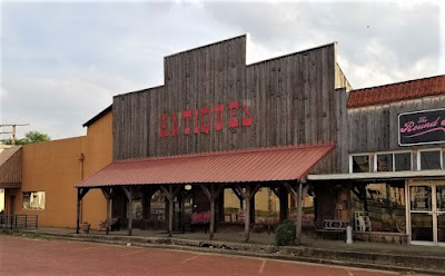
Gladewater is also known as the Antique Capital of East Texas. One of the antique shops in town looks kinda "antique-ish" itself!


And for the last geocache in town, I went to the Rosedale Cemetery (GC2208R). After finding the cache, I did spot this rather interesting headstone. I guess after the oil dries up, so does all the easy money.


We finished the day by driving over to Shreveport, Louisiana and checking into a hotel. After just over 600 miles of driving, it was time to call it a day.

To follow along on our travels and keep up with my latest blogs, you may do so here of course. But also by using you favorite of these social media platforms: FacebookMeWeGabRedditParlorTwitter, and Instagram. These all link directly to my profile. Again, please feel free to comment and / or share.

Saturday, July 17, 2021

2019-07-20: My Roadtrip Finding Giant Spiders, Memorials, Cemeteries, and Sculptures in North Central Texas

Hello travelers, geocachers, and explorers. For today's edition of AwayWeGo's Geocaching Adventures, I got out of work early on this Saturday. That gave me some extra time to stop for a few geocaches on the way back to Killeen. Today we'll visit a couple of memorials, cemeteries, and some interesting sculptures. We have over 300 miles of driving and an open seat in the GeoJeep, so hop on in and let's go for a ride.


My first stop was a short drive down the road to the Knox County Veterans Memorial located in the town of Benjamin (GC19EFG). This impressive memorial is dedicated to all the citizens from Knox County who have made the ultimate sacrifice in service to this country throughout the various wars.


After the memorial, I drove over to the Benjamin Cemetery for another geocache (GC5N4H7). There are around 800 burials dating back to 1886. Benjamin is the county seat and first town organized in Knox County. Hilory H. Bedford, president and controlling stockholder in the Wichita and Brazos Stock Company, founded the town in 1885 and named it for his son Benjamin, who had been killed by lightning. The town received its first mail service in 1884; Bedford was postmaster. In 1886 the Benjamin school was organized with R. P. Dimmitt, Mrs. Oliver, and Mrs. M. S. Berry as first teachers. Other early residents included W. P. Lane, who opened a saddle shop in 1885, Tom Isbell, the first sheriff of Knox County, and Dr. G. H. Beavers.


Driving south on Highway 6, passing through the town of Rule, Texas, I then stopped for two quick roadside geocaches (GC49G9G, GC4ZWD8).

Next up was the Capron Cemetery (GC5N3CT). It is a small rural backroads cemetery between Sagerton and Stamford in Haskell County. There are less than 100 interments here dating back to 1908. After a couple hours of research, I couldn't find much in the way of history for a town or community of Capron. Just a few obituaries for this cemetery. However...


...there was one story I found repeated in multiple newspapers across the country in February 1934, that mentioned the town.
           HEADLINE: Stunt Flyer Killed When Plane Crashes
        "Clarence 'Tailspin' Steffins, 28, Capron, Texas aviator, was killed here late today when the monoplane he was flying in an air circus fell in a spin. The crash was witnessed by his wife and a large crowd of spectators. A wing of the plane fell upon a motor car parked near the flying field, but occupants of the machine were not injured."

Continuing south, I arrive in the town of Stamford, Texas. Established by the railroad in the 1890's, Stamford was named by a railroad executive after his hometown in Connecticut. There was much history to see here, but I only stopped at one small corner to find a geocache (GC4ZWAZ) and see some interesting sculpture.

This first photo is often referred to "Bed Henge." Encircled like Stone Henge, the use of truck beds being inspired by the Cadillac Ranch around a cross made of wheels created by artist and Mayor Johnny Anders.


Mayor Anders also constructed his variation of the VW Bug / Spider sculpture. In this one though he used the Italian made Isetta microcar.


And finally, the Centennial Monument was dedicated June 30, 2000 to commemorate the 100 year anniversary of Stamford. A tribute to the area's railroad and ranching history.


Moving along southbound, there were several quick roadside geocache stops before reaching my last geocache of the day at Burnt Branch Cemetery (GC1DY6N). Located several miles northwest of Cross Plains, it's another small rural backroads cemetery with less than 100 interments which dates back to 1893. I also couldn't find much history about the cemetery or the area. There was one headstone that caught my attention. Private Benjiman Clarence Barclay was just 22 years old when he died on November 1st, 1918, just 10 days before the end of World War I. Searching old newspapers though, I couldn't find any stories on Private Barclay. But I can only assume he died while in service.


That's it for today. Come back again tomorrow for the return drive and see what else we can find...

Saturday, January 30, 2021

2019-05-04: Moving Day Roadtrip from Texas to North Carolina Day 2 in AL, GA, & SC Historic Cemetery, House, and Gas Station

Well after 16 hours of driving and geocaching yesterday, it's time to hit the road again for day two of my roadtrip from Texas to North Carolina. Todays drive will take me from Alabama, through Georgia, to South Carolina. So jump in and let's see what we can find!


My first stop was for the "Trussville Civitan" Alabama's First Geocache (GC126). This cache was hidden way back on January 2001. The are only 48 geocaches left that were hidden during that month. For geocaching statistics, there's a Jasmer Calendar that lets a cacher know what months their found caches were hidden in. I only had one open spot for 2001 and it was January.

So I arrived near the geocache location in the parking area of a park. At the center of the park was this Veterans War Memorial. Took a quick photo before I went for a walk.


There was a walking and biking paved trail down along the Cahaba River. There were quite a few people out getting their morning exercise along that trail. I'm more interested in what was in the woods and headed for that. Only a few hundred feet in and away from the curious eyes of the muggles, I found the 18 year old prize that has been found nearly 1700 times and added my name to the log. YAY! Now just two more spots for July and August of 2000 to fill in the blanks. Even harder as there are only seven of those in the United States.


Before leaving town I spotted this old gas station and just had to stop for a photo. The building was originally constructed as a Gulf Service station in the late 1950's. In 2013 the building was bought by Rocky Neason who turned it into the Classic Cars and Garage Museum. The station was transformed into a Standard Oil Gas Station replica and filled with many 50's & 60's era antiques collected by Rocky Neason during his 31 years in the industry. There was a 50's 2-seater T-Bird and a 60's mid-year Corvette behind the bay doors during my visit. But I understand the cars get traded out with his collection from time to time.


Moving along for a cache in St. Clair County, Alabama. "Final Resting Place" (GC7ETF0) is a geocache located in the Moody Cemetery. There are over 900 interments here dating back to 1860. With the muggle here mowing the lawn, I just found the cache and moved on.

A few quick park and grab caches for Calhoun County (GC82XM4, GC36J12) and a Dunkin Donuts coffee. Crossing the state line into Georgia, I exit I-20 for two more quick caches in Carroll County (GC7F5J3, GC7F5GY).

Now I'm in downtown Atlanta. Not my favorite place to be. But there are some "must do" geocaches there. Fortunately it is Saturday so traffic isn't too bad. The first is a D5/T5 challenge cache called "The Lower 48 States" (GC5EQQT). Located a couple blocks from the state capital, it is an easy cache to find yet a very difficult cache to claim. It requires you to find at least one cache in each of the lower 48 states. I've managed to find one in 49 states, only missing Hawaii.

Then I take a drive over to the historic Oakland Cemetery. It was established in 1850 as the Atlanta Cemetery on 6 acres of land southeast of the city. It was expanded to 48 acres by 1867 and renamed in 1872 to reflect all the oak and magnolia trees. The magnificent entry gate pictured below was constructed in 1896. From 1936 to 1976, the cemetery is neglected and fall into disrepair. The cemetery was placed on the National Register of Historic Places and a restoration began. Eventually the Historic Oakland Foundation was created and maintains the grounds. An average of 105,000 visitors tour this cemetery every year. Today it is my turn.


There are two virtual geocaches there. The first one I found is for "The Master" (GCD42A). The geocache is dedicated to one of golfs greatest players, Robert Tyre "Bobby" Jones, who won multiple Masters Championships in the 1920's. You'll find his headstone at the coordinates.

The other virtual geocache is called "The Lyin' Cache" (GC64DF). Oakland’s most centrally located character area is the final resting place of approximately 7,000 Confederate soldiers, many of whom are unknown. Following Oakland’s acquisition of additional land, this four-acre portion of the cemetery began its transformation in 1866 by the Atlanta Ladies Memorial Association (ALMA). Several hundred of these graves were originally marked by simple painted wooden headboards, then replaced by marble markers with rounded tops in 1890.

Near the center of the Confederate Burial Grounds, Oakland’s tallest monument is a sixty-foot granite obelisk memorial to the Confederate Dead. Erected by the ALMA, the foundation of Stone Mountain granite was laid in 1870, on the day of the funeral of Robert. E. Lee. The monument wasn’t completed and dedicated until Confederate Memorial Day, on April 26, 1874.

Flanking the obelisk to the northeast, the Lion of Atlanta monument commemorates unknown Confederate soldiers who died in the Battle of Atlanta. The large sculpture carved in marble from Tate, Georgia was commissioned by ALMA and unveiled in 1894. With the famous Lion of Lucerne as his model, T.M. Brady depicted a weeping lion, representing courage, dying on a Confederate flag.


(Jumping ahead to 2020... Sadly, political and civil unrest has led to vandalism of this nearly 130 year old memorial. On the nights of May 28, May 31, June 5, and June 6, 2020, members of BLM and Antifa went into Oakland Cemetery and vandalized the Lion statue, the Obelisk, some of the headstones, and one of the historical markers within the Confederate Burial Grounds. The geocache has been archived.)


The monument at the Neal family plot is one of the most beautiful in Oakland Cemetery. Mary Elizabeth (Lizzie) Neal was the daughter of Thomas Neal and Mary (Mollie) Cash. Before moving to Georgia from Louisiana three years earlier, she lost six siblings. She suffered from rheumatism for several months before her death. Her sister, Emma, cancelled a trip to the Arctic to care for her Lizzie in the last days of her life. Created by her father after her and her mother's deaths, Lizzie is thought to be represented by the woman on the right of the monument.


Three more interments here worth mentioning. Joseph Jacobs (1859-1929) was a businessman and pharmacist. While it was John Pemberton who invented Coca-Cola in 1885, it was Joseph Jacobs that introduced it to the public on May 8, 1886.

Also, there's Margaret Mitchell (1900-1949), author of the book "Gone With the Wind." On August 11, 1949, she was hit by a drunk driver while crossing the road at Peachtree and 13th with her husband on the way to see a movie. She died eight days later.

Finally, and jumping again forward to 2020, singer, songwriter, and actor Kenny Rogers was laid to rest in Oakland Cemetery on March 20, 2020.

All in all there are estimated to be about 70,000 interments here. I spent almost two hours exploring this cemetery and didn't get see it all. But I do need to get back on the road. It's late in the afternoon and I still have ground to cover. So let's get moving.

The next six geocaching stops were quick roadside or parking lot caches to get six new counties in Rockdale County (GC5GT56), Newton County (GC84173), Walton County (GC2X92M), Greene County (GC1AFQN), Taliaferro County (GC19WT6), and Warren County (GC1DZ99). Along the way traveling down these backroads, you often see houses or buildings that have long been abandoned and nature is consuming them. If you're anything like me you begin to wonder what they once were and what happened that allowed them to get to this condition.


Continuing over into McDuffie County we stop for some history. "The Rock House" (GC21JD6) is an 18th Century stone dwelling and is the only surviving house associated with the Colonial Wrightsboro Settlement (1768). Its builder, Thomas Ansley, used weathered granite, quarried in its natural form from the nearby geographic fall line, as building material. The granite, along with pine timbers and cypress shingles, gave the house a distinctive Georgia character. The architectural style of the Rock House is similar to stone houses in the Delaware Valley of New Jersey from which Ansley migrated. It is the earliest dwelling in Georgia with its original architectural form intact.

The home is now owned by the Wrightsboro Quaker Foundation and has been rumored to be haunted. The Augusta Paranormal Society visits this location from time to time.


Across the street is a large monument erected in 2002 among many small crosses. "The great tornado (Type 5) entered McDuffie County at RR Mile Post 42. At 12:45 PM, March 20, 1875 the Rock House lost windows, a cook house, corncrib and gin. In the center of the cemetery a giant oak was blown down. This marker was in the center of the tornados path." There are 18 names with dates listed of those who are believed to be buried there. The dates range from 1809 through 1848.

Continuing to research the history of the Ansley Family, the last name was Anne Ansley (born 1801 - died 1848) was the daughter of Abel and Lydia Ansley. Before she died, she married Willey Carter and they had eleven children. One of those eleven children was Littleberry Walker Carter, who eventually became the Great-Grandfather of President James Earl "Jimmy" Carter, Jr.


Crossing the Savanah River over into South Carolina, I stop at the Welcome Center for a quick geocache for Aiken County (GC1048M). Then take the first exit and drive north a couple miles for another quick roadside geocache to pick off Edgefield County (GC81EPX).

For Lexington County (GC4N3FV) it was "The Duck Inn Travel Bug Motel." A creative geocache container large enough to hold plenty of travel bugs and coins to move up and down the Interstate. And finally the last geocache of the day was in Richland County (GC4GX30).


Another long day of driving and geocaching. I continued to the town of Lugoff, SC where the next geocache is located. But instead of finding the cache, I check into a hotel. It's after 9 PM and I'm tired! Not a bad day though, picking up a lot of new counties and finding some historical places. I appreciate you riding shotgun and hope you enjoyed the roadtrip. We got one more day tomorrow to get to North Carolina. Until then, it's sleep time.

Friday, November 20, 2020

2019-03-04: A Packed Geocaching Road Trip from Texas to Minnesota and Back! Day 3 in NE, IA, and Arriving in Minneapolis!

What were we thinking! My Geocaching sidekick and navigator, CuteLittleFuzzyMonkey (CLFM) and I, both from Florida, now working and living in Texas, on a roadtrip in early March on the way to Minnesota in sub-freezing weather! Who's idea was this anyway? Oh yeah, it was my company's business training meetings I was driving to that we turned into a "fun" geocaching adventure! But it is so COLD!!

My back is feeling somewhat better. If you remember I twisted while reaching for a cache and pinched a nerve in my lower back. Between the Advil, stepping out into the cold, and returning to the heated seats of the GeoJeep, it's bearable.

Starting out at sunrise right here in Omaha, Nebraska, our first stop was at the Henry Doorly Zoo and Aquarium for a virtual geocache (GC7B6PE). Obviously they weren't open yet, but we got the needed logging requirements and continued on.


Not too far away and still in Omaha, we stopped by the Earthcache Sedimentary and Igneous Rocks (GC3VXN1). Located in the Spirit of Nebraska's Wilderness and Pioneer Courage Park, it consists of more than 120 individual bronze statues covering six city blocks. A pretty cool look of a wagon train making it's way through the rugged winter snow in Nebraska.


Before leaving town, we stopped to pick up Omaha's Easiest Multi-Cache (GC4PDC4). There wasn't anything special about this cache or anything interesting in it's location. But it did add another type of cache which bumped up my cache types for a single day from 4 to 5, as we finished with an earthcache, an event, a multi, a traditional, and a virtual cache.

Making our way into Iowa, we stopped at Karen's 71-20 T.B. Rest Stop (GC1DEYB). This was located in Early, IA which gives me Sac County. It's also in the Protestant Union Cemetery. There's only 21 graves here, all from the late 1800's. The town of Early began in 1878. In 1882, most of the town moved 1 1/2 miles to the north to be closer to the railroad.

We stopped for gas on the outskirts of town. Go figure there's another cache in the parking lot (GC4C32V)!

Continuing north on US-71 in Iowa, our next stop was for a virtual geocache that I never would have figured there's be one! Who knew there would be a lighthouse in IOWA of all places? Located on the northshore of Storm Lake, the Siebens Lighthouse (GCG72J) was built in 1992. This was about as close as I could get with the snow being up to my knees already.


Getting back to US-71 northbound, it's a two-lane highway. Having my back issue on day one and having to deal with that, throw in the single digit freezing temps, can I atleast have a day WITHOUT any new issues? Nope, it just ain't gonna happen!

As we're driving northbound at 60-65 MPH, the 18-wheeled farm trucks are hauling 60-65 MPH southbound. As each one passes by, the GeoJeep hood catches the 120 MPH wind through the front and causes a violent shutter of the hood. Well the frozen rubber latches on the sides of a Jeep hood just couldn't hold it any longer. Suddenly the driver side latch snapped and the corner of the hood just popped up about a foot! Scared the crap out of me!

I pulled over to take a look. Now I got nothing holding the drivers side of the hood secure. Now even at just 20-30 MPH and pulling way over onto the shoulder, the passing trucks just blow the hood up. I manage to drive a couple of miles down the road to this business entrance where I can get clear of traffic and try to figure out a solution. I can only mess with it for a minute or two before having to get back in the GeoJeep to thaw my fingers out before they fall off from frostbite! I got some basic hand tools and a package of zip ties. But with the brackets still in place, only the rubber piece broke off, there's nothing to run the zip tie through.

After about 30 minutes, someone from the shop pulled in and asked if I needed help. He let me pull inside the back of the building so that I could work on it without my fingers freezing. I did manage to get the top part of the bracket off. That allowed me to run the zip ties through the bolt holes and attach to the bottom bracket. GREAT!

Well not really. It didn't take long in those freezing temps for those plastic zip ties to become brittle and pop. After a couple of singles breaking, then two at a time, and even three! They wouldn't last at speed. So I had to continue to slow down and pull onto the shoulder every time an 18-wheeler passed by.

Nearly an hour later we finally made it up to the town of Spencer, Iowa. There they had a Jeep dealer. But they didn't stock any of those latches. Now what... There was a Menards around the corner, so I drove over there. Looking around for ideas, I found some tie wire used for holding rebar in place before pouring concrete. I bought it and a pair of wire cutters. But in trying to tighten it down the wire kept breaking. It was too thin.

Back inside I looked at other types of wire. I found another that was a little thicker and covered in a flexible plastic. So I buy that one. A little harder to snake through the holes, but I managed to tighten the hood down securely!


After that ordeal we needed a break and stopped over at Arby's for a bite to eat!

On the road again, we finally made it into Minnesota up US-71 northbound. We then pickup I-90 eastbound making up some lost time. The wind was really blowing the snow across the highway.


Upon arriving in Blue Earth, MN, there was one virtual geocache that we just couldn't pass up. I mean how can you pass up the huge Jolly Green Giant and Sprout! (GC628B)


Northbound on US-169, we stopped for another virtual geocache in Kasota, MN. Called Designated Trout Stream (GC938E), it was located along the highway in the Seven Mile Creek Park. The snow was pretty thick there and I put the GeoJeep in 4x4 mode to make sure I can maneuver around. Got the information we needed and got back into the warm GeoJeep.


Two more virtual geocaches, one for the original location of the Jolly Green Giant (GC9392) which was originally called the Minnesota Valley Canning Company. And the other was at a Veterans War Memorial (GCDF77).

Finally we made it to Minneapolis! But due to todays delays, we don't have much time. We check into the hotel and get unpacked quickly. Then off to Teresa's Mexican Restaurant where we are hosting our geocaching event "Texas Meets Minnesota in Mexico" (GC83PEG). It was a great time spent with and meeting the local geocachers. We had 18 cachers come out to welcome us!


Well that's it for Day #3 of our roadtrip. I get to spend the next the next two days in a conference room for some training meetings. CLFM will be out in the GeoJeep roaming all over the place finding more caches. Atleast I'll be staying warm!

Be sure to stop back by for the return trip back to Texas. We're not constrained by time for the return trip so who knows where we'll end up!

There are new ways to follow me. Follow the blog directly by using buttons on the right of your computer screen. Or through various social media platforms: Facebook, MeWe, Parler, Gab, Twitter, Instagram, MAGAbook, and Reddit. Follow us on any or all of these platforms and whichever you choose, please leave your comments. We'd love to hear from you and it encourages us to continue sharing our adventures.

See you next time...