Showing posts with label monument. Show all posts

Saturday, March 20, 2021

2019-05-27: Roadtrip Day3! The North Carolina County Challenge: Finding an Old School, Civil War History, BBQ, and Railroad Museums

So today is Day 3 and the last day of my holiday weekend roadtrip geocaching around North Carolina to try and complete my caching county map. Unfortunately though, like I said in Day 2's blog, I had to turn the corner and start heading east before I was able to get all the counties. But I still have more to get to today as I travel east along the south-central part of North Carolina. 

Let's hit the backroads and drive through North Carolina history. The passenger seat is open on the GeoJeep. Climb in and see what we can find... 


After checking out of the hotel bright and early this morning, I drove up to Burke County for my first geocache (GC6GJMA). This one was hidden by a geocacher outside her own house. Problem was that she moved away and it doesn't look like the house has been occupied in a while. Probably won't last much longer.

Moving right along into Alexander County for a quick parking lot cache at a grocery store (GC7MF94). Going east on I-40 into Davie County, I exit on US-64 to the town of Mocksville. I find the quick cache (GC467NN) near the fire station and keep going.

Entering the town of Lexington in Davidson County, I stop in the town square for a look back into history. The name Lexington was given to a crossroads settlement that consisted of a store, a tavern, and a few houses in 1775 shortly after the first skirmish of the Revolutionary War in Lexington, Massachusetts. The town was officially incorporated in 1828. The first Davidson County court house was completed in 1858, and was the only masonry building in the county at that time. The courthouse was used as barracks for Yankee soldiers in the civil war during which was damaged by fire in 1865, and rebuilt in 1867.


Lexington is also known for its BBQ (GC6C85). North Carolina has a long history regarding barbecue. The Spanish brought hogs to the Americas in the 1600's. As the pigs took over, pork became the meat of choice. Over time, the barbecue methods from around North Carolina converged into the style that’s known today as Eastern-style barbecue, a thin tangy sauce made with vinegar and red pepper flakes. Once the meat is smoky and tender, it’s chopped up and mixed with more of the vinegar sauce. Eastern-style barbecue is served by the plate or on a bun, usually accompanied by white cabbage and mayonnaise slaw. This is the original style of North Carolina bbq.

Sometime around World War I, an East-West split started to happen in the towns and cities of the Piedmont region west of Raleigh. There, pitmasters started using only the shoulder of the pig and vendors started adding ketchup or tomato paste to the traditional vinegar sauce. The style grew in popularity throughout the Piedmont region. It especially took hold in Lexington, which became the center point for Western-style barbecue. Barbecue is big in Lexington. The town of just under 20,000 hosts an annual barbecue festival that draws upwards of 175,000 attendees.


One more quick roadside geocache (GC46YJ8) in Davidson County at a historical marker for the Yadkin College which opened in 1856. It began as the Yadkin Institute, a high school for young men by the Methodist Church. It was re-chartered by North Carolina as Yadkin College in 1861.

Then followed by a quick roadside geocache (GC1V14A) in Rowan County.

Moving south into Stanly County was another historic old school building (GC15ENE), pictured at the top of this page and the next two. Pfeiffer University is a private university located in Misenheimer, North Carolina, established in 1885. The school first began its operation on the edge of Hudson, NC and was called Oberlin School, and was later endowed by Mrs. Mary P. Mitchell and was named in her honor as the Mitchell School. A fire destroyed the original school in 1907, and it was then moved to Lenoir. The new location proved to be inadequate and was relocated in 1910, to Misenheimer.


The Mitchell School began awarding high school diplomas in 1913, and began offering junior college classes in 1928. In 1934, the Pfeiffer family of New York City, gave several generous financial gifts to the school. The school changed its name to Pfeiffer Junior College, after it was accredited the same year. In the 1950's, the school began offering senior level college courses, and was then accredited as a four-year college in 1960. In 1996, the college received university status, as Pfeiffer University.


On the way to my next set of geocaches I passed through Albemarle, NC. One of those always interesting roadside attractions was spotted outside Jerry's Automotive. A shortened VW Bus with the monster head and arm sticking out that reminded me of the old Ed Roth or Rat Fink CARtoon drawings. I had to stop for a photo.


My next two geocaches were also quick roadside stops, one in Montgomery County (GC1M50J) and the other in Union County (GC82RBK).

Driving down to my next geocache, I passed by this old abandoned house. It looked like it was once a nice home. I wonder who once lived here and why they abandoned such a nice house. It's a shame it's just falling apart.


The next geocache (GC4JA4H) and county comes with a ghost story. The Ghosts of Indian Rock In Anson County, about 3 miles northeast of Wadesboro there's a small bridge crossing a creek. Most people drive across the bridge without a thought of what lurks nearby, but the locals know. They know it as Indian Rock. Near the creek known as Gould's Fork Creek there is a cave that was carved by Catawba Indians long before the white man settled in Anson County. But it's what happens here that has the locals spooked. That's all I'll share with you. You can read "the rest of the story..." over on the geocache page.

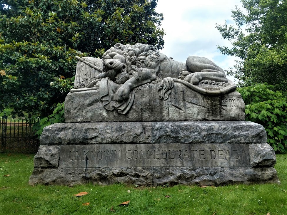
Moving over into Richmond County, I had two virtual geocaches on my to-do list. "Justice Rolls Down" (GCG67R) was the virtual located in the town of Rockingham. Outside the county courthouse were three historical markers and a monument. The historical markers were for a Brigadier General, a Governor, and a U.S. Congressman. The monument honors the county's veterans who served.


The next virtual geocache (GCG67V) was located in the town of Hamlet, NC. The first building constructed on Main Street by E. A. Lackey in 1901. It once was Carsons Drugs, Hamlet Pharmacy, and then Birmingham Drug which remained in business for over 50 years until 2019. During WWII, soldiers stayed in the rooms upstairs while waiting to board their trains. In 1990 the movie Billy Bathgate was filmed here and this was used as the hotel and restaurant in the movie.


Across the street from the historic train depot was the Tornado Building. I thought it had something to do with the weather. After some research for this blog, I discovered it to be a railroad museum.

The Tornado was the first steam engine locomotive in North Carolina. Originally built in 1839 by D.J. Burr & Co. of Richmond, Virginia, the Tornado was classified as a 4-2-0 steam engine locomotive. The numbers stood for four leading wheels, two driving wheels and no trailing wheels and a total length of 50 feet including tender and box car. It was one of four locomotives delivered to the Raleigh & Gaston Railroad, the others being the Tempest, Volcano and Whirlwind.

Weighing in at six and a half tons, the Tornado was on the light side by most locomotive standards; however she pulled thirty loaded cars and routinely hauled up to 160 tons of freight on 50-mile runs between the towns of Henderson and Gaston, North Carolina. In 1840, the Tornado became the first steam locomotive to reach the state capital of North Carolina on the Raleigh & Gaston Railroad, where she arrived to gawking crowds of residents.

In the spring of 1865, the Union Army captured the Tornado when they took the North Carolina Railroad between Goldsborough and Raleigh. After much use and a gradual phase out of this model in favor of the newer 4-4-0 models, this Tornado replica was originally rebuilt in 1892 for the Raleigh Centennial Exposition. It was featured in the Great Centennial Celebration parade in October of that same year. It arrived in the Town of Hamlet in 1950 and was again fully-restored with North Carolina DOT funds between the years of 2007-2009.

The building in which it is now housed was specially-created to accommodate the Tornado. The structure also houses a 1927 Model-T, a 1930 Model-A Ford and a 1949 fire engine. Now I wish I would have checked to see if it was open so I could go inside.


In the late 1800's, John Shortridge established a woolen and saw mill along Marks Creek in the sand hills of North Carolina. In 1879, a railroad running from Wilmington passed through the area that would become Hamlet to the Pee Dee River, where it connected to a line running to Charlotte. Another railroad was being built from Raleigh through to Augusta; it was through the influence of early residents that these tracks also crossed through Hamlet. 

The Hamlet depot, the only Victorian Queen Anne style station in North Carolina, was built in 1900 for the Seaboard Air Line Railroad as both a passenger station and division headquarters. This two-story station was originally constructed at the crossing of the Raleigh and Augusta Air Line and Central Carolina Railways. Hamlet grew with the railroad, as it provided hospitality for travelers passing from New York to Florida. By 1936, Hamlet was dubbed the “Hub of the Seaboard,” with five Seaboard Air Line Railroad lines leading out from the city and about 30 passenger train departures each day. Freight trains still come to Hamlet for maintenance at the CSX Transportation Maintenance Shops.


Running out of time, I start making my way back as quickly as possible. In Moore County I find a quick roadside geocache along US-1 (GC1WYKK), one in Scotland County (GC1W6AA), another in Hoke County (GC3WBFA), Lee County (GC2QJFE), and finally Chatham County (GC7TCRR).

That is all the time I had for this weekend. Unfortunately, I couldn't make it as far west as I wanted too and had to leave those counties for another roadtrip. The other two counties in the middle, well I'm not exactly sure how I missed those. Still a good trip since just a few weeks ago when I first arrived in North Carolina I think I only had about 24-25 counties completed. And I still have some time left here. Maybe I can get those on the way back to Texas. 


Saturday, February 20, 2021

2019-05-12: Geocaching Counties in OBX and NE North Carolina Visiting Kitty Hawk, a Crazy Bird, and Grave Digger

Hey guys! Welcome back! So if you remember from yesterdays blog, I started working on a solar project in North Carolina this past week. Yesterday, the first Saturday off, I geocached the southeast corner of the state to pickup the missing counties I needed for my geocaching map. Today I'll be taking a roadtrip over to the Outer Banks (OBX) and the northeast corner of the state for more counties. So let's get going...


From where I'm staying in Blounts Bay, I first have to go west around the Pamlico River into the town of Washington to pickup US-264 eastbound. By the way, originally called Forks of the Tar, the town of Washington, NC was renamed in 1776 and the first to be named in honor of George Washington.

Sometimes while driving the rural backroads around the country you get to discover some unexpected photo ops that you just have to pull over for. This one was on the way to my first geocache. Driving along US-264 and crossing over Scranton Creek, I spotted this old sailboat that was probably victim of one of the many storms that have hit the Carolinas. My first thought was "GILLIGAAANNN!!!"


And speaking of storms... my first geocache was in Hyde County. It was located at a roadside historical marker for the Providence Methodist Church (GC57KRV). There wasn't anything to see here other than the sign and a cornfield. But back on September 16-17, 1876, the church was "moved by the hand of God." It seems that the church floated away from the center of town during a flood and landed here. Then the following day when the waters receded, it pushed the church back almost to the exact spot it started in town nearly two miles away!

Moving on up into Tyrrell County, I stopped for a quick roadside cache (GC1FEDM). From there were continued the backroads north into Columbia, NC and picked up US-64 eastbound. Usually driving the backroads you can encounter some unexpected sites. I passed by a Seafood Market with about a dozen of these metal sculptures. Here's just a couple of them.


Crossing the Alligator River into Dare County, my next geocache (GC2Y1PC) was at the remains of the old ferry docks. The ferry established in 1931 by W. T. Baum while it was State Highway 90 and gave travelers a way of crossing the river verses driving all the way around to the south. Soon thereafter the state began subsidizing Mr. Baum and providing a free service to users. Upon the completion of US-64 in the 1950's, more traffic arrived and additional ferry crossings scheduled. Eventually a bridge was built over the river connecting both sides of US-64 in 1962 and the ferry abandoned. You can still see the remains of the docks used by so many in the past.


Continuing on US-64 east, I cross over Croatan Sound onto Roanoke Island. It was here where the first English colonists came and attempted to settle back in 1585. On the third attempt 90 men, 17 women, and 11 children were left behind on the island in 1587. By the time the supply shipped returned again in 1590, the colonists had disappeared never to be seen again.

Also on the island are my next three geocaches locates at the Outer Banks Welcome Center. The first one called OBX Velkominne Respite (GC38G6K) was a very creative cache at one of the picnic tables with over 200 favorite points. From there take a stroll down the boardwalk for a rather difficult magnetic container hide (GC4K4NH) about halfway down.


I hadn't planned on spending so much time here. But the caches and the views were worth it. And finally, down at the very end of the pier was the final geocache to be found here (GC477R6). I guess the best way to describe it would be to leave you with a couple videos:


My next geocache in Dare County on the OBX was the most historic and where I spent the most time. "Dawn of Aviation" (GCB57D) is a virtual geocache on Kill Devil Hill near Kitty Hawk. It was on this hill where two bicycle shop owners from Ohio, Orville and Wilbur, built a flying contraption and brought it down here for a test flight. On December 17, 1903, the Wright Brothers made four successful flights gradually increasing in lengths at 120 feet, 175 feet, 200 feet, and finally 852 feet.

After passing both the House and Senate, President Calvin Coolidge signed the act to establish the Kill Devil Hill National Monument on March 2, 1927. The first monument was a 10-ton granite marker placed on December 17, 1928 at the approximate location of the 1903 liftoff and a cornerstone was laid atop Kill Devil Hill for the larger monument. Construction of the 60-feet art-deco designed triangular monument was completed in November 1932.


From the monument at the top of the hill looking out over the flight path. The parking and visitor center is off to the right side.


Just one of the many scenes in Sculpture Gardens. These life sized statues showcase the many people, photographers, the plane and more there on that momentous day.


One last geocache here on the outer banks turns out to be a webcam cache. Whenever you encounter a webcam cache you want to try and get it. They're no longer added so once they've been archived, they're gone. "Sun n' Surf" (GC2585) webcam was atop the Shrimp Shack looking out over the pier. How webcams used to work was a two-person activity. You'd have to stand in the correct spot, call someone at a computer who could screen shot the photo. Now with smartphones, you can do it yourself.


Leaving the OBX on US-158 north back on the mainland. Another one of those "Hey Lookie There" moments! Passing through Poplar Branch, I spot the Grave Digger monster truck and the Digger's Dungeon shop! Oh, I just HAD to pull over for some roadside attraction photos! Posing the GeoJeep next to the oversized Grave Digger of course. And how about the fastest mailbox in the world too.


Making my way back, I entered into Camden County and picked up a quick roadside geocache in some trees (GCTEQN). Nothing special about the cache or the place, but I did get a photo of this disturbed young bird that I wasn't sure it could fly yet. It was just hopping from branch to branch. Then just gave me that look like I just woke it up.


One more quick roadside geocache (GC4MHAH) for Pasquotank County and then I call it a day. Time to get back and prepare for work tomorrow. I picked up a lot of new caching counties this weekend. Hmmm now to plan next weekends county caching run. See you then...

Saturday, January 30, 2021

2019-05-04: Moving Day Roadtrip from Texas to North Carolina Day 2 in AL, GA, & SC Historic Cemetery, House, and Gas Station

Well after 16 hours of driving and geocaching yesterday, it's time to hit the road again for day two of my roadtrip from Texas to North Carolina. Todays drive will take me from Alabama, through Georgia, to South Carolina. So jump in and let's see what we can find!


My first stop was for the "Trussville Civitan" Alabama's First Geocache (GC126). This cache was hidden way back on January 2001. The are only 48 geocaches left that were hidden during that month. For geocaching statistics, there's a Jasmer Calendar that lets a cacher know what months their found caches were hidden in. I only had one open spot for 2001 and it was January.

So I arrived near the geocache location in the parking area of a park. At the center of the park was this Veterans War Memorial. Took a quick photo before I went for a walk.


There was a walking and biking paved trail down along the Cahaba River. There were quite a few people out getting their morning exercise along that trail. I'm more interested in what was in the woods and headed for that. Only a few hundred feet in and away from the curious eyes of the muggles, I found the 18 year old prize that has been found nearly 1700 times and added my name to the log. YAY! Now just two more spots for July and August of 2000 to fill in the blanks. Even harder as there are only seven of those in the United States.


Before leaving town I spotted this old gas station and just had to stop for a photo. The building was originally constructed as a Gulf Service station in the late 1950's. In 2013 the building was bought by Rocky Neason who turned it into the Classic Cars and Garage Museum. The station was transformed into a Standard Oil Gas Station replica and filled with many 50's & 60's era antiques collected by Rocky Neason during his 31 years in the industry. There was a 50's 2-seater T-Bird and a 60's mid-year Corvette behind the bay doors during my visit. But I understand the cars get traded out with his collection from time to time.


Moving along for a cache in St. Clair County, Alabama. "Final Resting Place" (GC7ETF0) is a geocache located in the Moody Cemetery. There are over 900 interments here dating back to 1860. With the muggle here mowing the lawn, I just found the cache and moved on.

A few quick park and grab caches for Calhoun County (GC82XM4, GC36J12) and a Dunkin Donuts coffee. Crossing the state line into Georgia, I exit I-20 for two more quick caches in Carroll County (GC7F5J3, GC7F5GY).

Now I'm in downtown Atlanta. Not my favorite place to be. But there are some "must do" geocaches there. Fortunately it is Saturday so traffic isn't too bad. The first is a D5/T5 challenge cache called "The Lower 48 States" (GC5EQQT). Located a couple blocks from the state capital, it is an easy cache to find yet a very difficult cache to claim. It requires you to find at least one cache in each of the lower 48 states. I've managed to find one in 49 states, only missing Hawaii.

Then I take a drive over to the historic Oakland Cemetery. It was established in 1850 as the Atlanta Cemetery on 6 acres of land southeast of the city. It was expanded to 48 acres by 1867 and renamed in 1872 to reflect all the oak and magnolia trees. The magnificent entry gate pictured below was constructed in 1896. From 1936 to 1976, the cemetery is neglected and fall into disrepair. The cemetery was placed on the National Register of Historic Places and a restoration began. Eventually the Historic Oakland Foundation was created and maintains the grounds. An average of 105,000 visitors tour this cemetery every year. Today it is my turn.


There are two virtual geocaches there. The first one I found is for "The Master" (GCD42A). The geocache is dedicated to one of golfs greatest players, Robert Tyre "Bobby" Jones, who won multiple Masters Championships in the 1920's. You'll find his headstone at the coordinates.

The other virtual geocache is called "The Lyin' Cache" (GC64DF). Oakland’s most centrally located character area is the final resting place of approximately 7,000 Confederate soldiers, many of whom are unknown. Following Oakland’s acquisition of additional land, this four-acre portion of the cemetery began its transformation in 1866 by the Atlanta Ladies Memorial Association (ALMA). Several hundred of these graves were originally marked by simple painted wooden headboards, then replaced by marble markers with rounded tops in 1890.

Near the center of the Confederate Burial Grounds, Oakland’s tallest monument is a sixty-foot granite obelisk memorial to the Confederate Dead. Erected by the ALMA, the foundation of Stone Mountain granite was laid in 1870, on the day of the funeral of Robert. E. Lee. The monument wasn’t completed and dedicated until Confederate Memorial Day, on April 26, 1874.

Flanking the obelisk to the northeast, the Lion of Atlanta monument commemorates unknown Confederate soldiers who died in the Battle of Atlanta. The large sculpture carved in marble from Tate, Georgia was commissioned by ALMA and unveiled in 1894. With the famous Lion of Lucerne as his model, T.M. Brady depicted a weeping lion, representing courage, dying on a Confederate flag.


(Jumping ahead to 2020... Sadly, political and civil unrest has led to vandalism of this nearly 130 year old memorial. On the nights of May 28, May 31, June 5, and June 6, 2020, members of BLM and Antifa went into Oakland Cemetery and vandalized the Lion statue, the Obelisk, some of the headstones, and one of the historical markers within the Confederate Burial Grounds. The geocache has been archived.)


The monument at the Neal family plot is one of the most beautiful in Oakland Cemetery. Mary Elizabeth (Lizzie) Neal was the daughter of Thomas Neal and Mary (Mollie) Cash. Before moving to Georgia from Louisiana three years earlier, she lost six siblings. She suffered from rheumatism for several months before her death. Her sister, Emma, cancelled a trip to the Arctic to care for her Lizzie in the last days of her life. Created by her father after her and her mother's deaths, Lizzie is thought to be represented by the woman on the right of the monument.


Three more interments here worth mentioning. Joseph Jacobs (1859-1929) was a businessman and pharmacist. While it was John Pemberton who invented Coca-Cola in 1885, it was Joseph Jacobs that introduced it to the public on May 8, 1886.

Also, there's Margaret Mitchell (1900-1949), author of the book "Gone With the Wind." On August 11, 1949, she was hit by a drunk driver while crossing the road at Peachtree and 13th with her husband on the way to see a movie. She died eight days later.

Finally, and jumping again forward to 2020, singer, songwriter, and actor Kenny Rogers was laid to rest in Oakland Cemetery on March 20, 2020.

All in all there are estimated to be about 70,000 interments here. I spent almost two hours exploring this cemetery and didn't get see it all. But I do need to get back on the road. It's late in the afternoon and I still have ground to cover. So let's get moving.

The next six geocaching stops were quick roadside or parking lot caches to get six new counties in Rockdale County (GC5GT56), Newton County (GC84173), Walton County (GC2X92M), Greene County (GC1AFQN), Taliaferro County (GC19WT6), and Warren County (GC1DZ99). Along the way traveling down these backroads, you often see houses or buildings that have long been abandoned and nature is consuming them. If you're anything like me you begin to wonder what they once were and what happened that allowed them to get to this condition.


Continuing over into McDuffie County we stop for some history. "The Rock House" (GC21JD6) is an 18th Century stone dwelling and is the only surviving house associated with the Colonial Wrightsboro Settlement (1768). Its builder, Thomas Ansley, used weathered granite, quarried in its natural form from the nearby geographic fall line, as building material. The granite, along with pine timbers and cypress shingles, gave the house a distinctive Georgia character. The architectural style of the Rock House is similar to stone houses in the Delaware Valley of New Jersey from which Ansley migrated. It is the earliest dwelling in Georgia with its original architectural form intact.

The home is now owned by the Wrightsboro Quaker Foundation and has been rumored to be haunted. The Augusta Paranormal Society visits this location from time to time.


Across the street is a large monument erected in 2002 among many small crosses. "The great tornado (Type 5) entered McDuffie County at RR Mile Post 42. At 12:45 PM, March 20, 1875 the Rock House lost windows, a cook house, corncrib and gin. In the center of the cemetery a giant oak was blown down. This marker was in the center of the tornados path." There are 18 names with dates listed of those who are believed to be buried there. The dates range from 1809 through 1848.

Continuing to research the history of the Ansley Family, the last name was Anne Ansley (born 1801 - died 1848) was the daughter of Abel and Lydia Ansley. Before she died, she married Willey Carter and they had eleven children. One of those eleven children was Littleberry Walker Carter, who eventually became the Great-Grandfather of President James Earl "Jimmy" Carter, Jr.


Crossing the Savanah River over into South Carolina, I stop at the Welcome Center for a quick geocache for Aiken County (GC1048M). Then take the first exit and drive north a couple miles for another quick roadside geocache to pick off Edgefield County (GC81EPX).

For Lexington County (GC4N3FV) it was "The Duck Inn Travel Bug Motel." A creative geocache container large enough to hold plenty of travel bugs and coins to move up and down the Interstate. And finally the last geocache of the day was in Richland County (GC4GX30).


Another long day of driving and geocaching. I continued to the town of Lugoff, SC where the next geocache is located. But instead of finding the cache, I check into a hotel. It's after 9 PM and I'm tired! Not a bad day though, picking up a lot of new counties and finding some historical places. I appreciate you riding shotgun and hope you enjoyed the roadtrip. We got one more day tomorrow to get to North Carolina. Until then, it's sleep time.

Sunday, January 17, 2021

2019-04-21: A Roadtrip from Oklahoma to Texas and Visiting a Petrified Villa, an 1800's Church, and the Historic Chisholm Trail

So after spending the day yesterday in Oklahoma at the Wichita Mountains Wildlife Refuge, today is the roadtrip back to Killeen, Texas. And of course we can't take a drive that far without any geocaching stops. Anybody want to go for a ride with us? There's always room for virtual passengers. Let's fuel up and hit the road.


After checking out of the hotel this morning, I walked across the street to the grassy area by the I-44 onramp. A quick geocache in a tree so close that I just can't leave without finding (GC2W45H).

There were some other geocaches around Lawton with some high favorite points and we wanted to check those out also. This one was a very creative container (GC47ZEA). The geocacher took some time creating this one. You could almost call it "Me and Mini-Me"! Oh, and the name of the road that this coffee shop is located...: Cache Road! Definitely gets another favorite point from us too. It's too bad that the coffee shop itself wasn't open this early on a Sunday Easter morning because we hadn't found our morning coffee yet.


Another high favorite geocache was a virtual cache at the Great Plains Museum (GC81E5). We like museums. But of course not open at this time. So a quick photo by the "long-horn bison"?


Our last geocache (GC5FDZ7) in Lawton, Oklahoma was at the Elmer Thomas Park. It a large park behind the Great Plains Museum. It was called "Circle the Wagons" and it was at an old covered wagon display. A tricky cache to find because the camo blends in really well. One out of three cachers end up logging a DNF. However, I was fortunate enough to find this one. Though I was so intent on finding this one I forgot to take a photo of the wagon.

Driving over to Duncan, Oklahoma for our next virtual geocache (GC1C59) at the Chisholm Trail Heritage Center. The Chisholm Trail was a trail used in the post-Civil War era to drive cattle overland from ranches in Texas to Kansas railheads. The trail was established by Black Beaver, a Delaware Indian scout and his friend Jesse Chisholm, a merchant and part Cherokee. The trail was used from 1867 through 1884. The herds on the trail rides usually numbered around 2500 to 3000 head of cattle each, but have been as many as 10,000 in a single herd. The herds were usually spaced about 10 miles apart for the long journey, which was about a day apart. At this geocache location is a large bronze statue representing such a cattle drive.


Also in the town of Duncan is one that I just couldn't pass up on. Because I work as a construction surveyor, it was a given that I go find a geocache called "The Survey Base Line" (GC6DZZG). "The distinctive checkerboard pattern of land boundaries in Oklahoma and all across the West was conceived by Thomas Jefferson in the early 1780's, long before the rough and rugged character of this vast wilderness had been charted. Jefferson was the grand architect of the distinct western landscape. In the late 1800’s government surveyors were commissioned to survey the public lands for sale or grant to the public."

This cache is located at a historical geographic monument for the Indian Base Line in Oklahoma. The "Initial Point was established by the U.S. Government in 1870. All Oklahoma except the panhandle was then divided into townships North and South and Ranges East and West of the Initial Point. The Indian Base Line is two-tenths of a mile south of this point on Beech Road. Duncan is 41 miles west of the Initial Point. The stones in this monument were taken from the Initial Point."


Our last stop in Addington, Oklahoma is another geocache and historical monument marking the Chisholm Trail Lookout Point (GC5W7H5). The two hills here represented landmarks used by Cattle Drivers on the Chisholm Trail. As they came out of the Red River valley they could see these two hills and used them to drive the cattle north to this location. Originally known as Lookout Point, they became known as Monument Hills. The Chisholm Trail and millions of Longhorns, went just to the east of this hill marked by this monument.


Driving along US-81 now down into Texas, we made a quick roadside picnic area stop to grab two geocaches (GC10MJD, GC431J6).

Arriving in Decatur, Texas, we made a "must-do" geocaching stop for a roadside attraction Americana history. "Petrified" (GC3X4ZF) is located at the Texas Tourist Camp Complex. From the historical marker: Local businessman E.F. Boydston (1888-1945) purchased this site, a former seed lot, in 1927 for $400. Recognizing a potential business opportunity in offering services to the traveling public, he built a wooden shed and gas station in 1927. Travelers were allowed to build campfires during overnight stays, and by 1931 Boydston added three wooden cabins with garages to the camp complex. The buildings were later faced with rock, and more cabins and garages were added in 1935. The original wooden gas station (photo at top of page) was covered with petrified wood in 1935 when the highway was widened and remained in operation by the Boydston family until 1988.


The Texas Lunchroom, a one room frame building, was built in 1929. Renamed The Texas Cafe in 1935 and refaced with stone to match the other buildings in the complex, it was enlarged to provide second floor living quarters. Popular with local high school and college students, as well as families and the traveling public, it was closed in the 1960's after a highway bypass built west of town diverted traffic from this area. The cafe re-opened in 1993. One of the few intact examples of tourist camps built throughout Texas in the mid-20th century. This property is significant for its association with the early development of automobile tourism.


Our last stop, also in Decatur, was for the geocache "Goin' to the Chapel" (GC198AR). The Episcopal Church of the Resurrection is the oldest original church building in Decatur. Consecrated by great missionary Bishop, the Rt. Rev. A.C. Garrett. Erected facing Main Street (2 blocks west of square) in 1889. Known as "the little church with the crosses", by 1912 it had deteriorated, but it was restored and moved facing Walnut Street.

In 1940 the building was sold and used as a mattress factory. Then it was rescued the same year and moved to this location, with the sanctuary placed symbolically to the east towards Jerusalem.


So that's it for today's roadtrip back home from Oklahoma to Texas. Thanks for riding along with us. Feel free to leave your comments and/or share our adventures with your friends. You can find us on most social media platforms:  FacebookMeWeParlerGabTwitterInstagramMAGAbook, and Reddit. Follow us on any or all of these platforms.

See you next time...

Saturday, December 19, 2020

2019-04-07: Geocaching Through Texas Independence History in Cemeteries, Memorials, and a Haunted House

Welcome back to AwayWeGo's Geocaching Adventures Blog. My geocaching name is AwayWeGo.US and these are stories about our travels around the United States. Like most weekends, today is another Sunday driving 360+ miles back to work day. I live in Killeen, Texas and drive down to Falcon Lake in the Rio Grande Valley where I work as a construction surveyor during the week.


After about 30 minutes of driving, my first stop was at an IHOP in Georgetown for breakfast. Before leaving, I grab the quick geocache just outside the parking lot (GC20T2K).

I decided to make a detour and attend this geocaching event in Victoria, TX. Heading down US-183, I made a stop at the San Pablo Cemetery in Lockhart for another quick geocache find (GC3QKN0). The San Pablo Cemetery has about 100 burials beginning in the late 1930's and is still in use today.

Stopping again at the Luling City Cemetery for another cache (GC3VCVD), you also get a view of a giant watermelon. In 1954, Hermon Allen, principal of the Luling Elementary School, proposed the idea of a celebration to honor the growers and promote the Luling watermelon market. The festival includes a watermelon contest for the largest grown. The biggest Black Diamond champion melon in the festival’s history weighed in 141 pounds. The event has grown so large that as many as 30,000 people have attended.


Arriving down in the town of Gonzales, TX, I stopped for a virtual geocache at the "Old Time Justice" (GCGB8Q). The jail was built in the 1880's and is now a museum. It wasn't open at this time. I'll have to return one day to take a tour myself. The photos of it look interesting.

There's a legend that while Albert Howard was waiting for the date of his hanging from his jail cell, he had a view of the clock tower on the courthouse to watch the time. Until the very end he swore of his innocents and said that the four faces of the clock tower would never keep the same time again as long as he was hanged. Over the years and several attempts to fix it, the clocks have never kept the same time.


Then there's also the "Immortal 32" virtual cache (GCG84Q). In February 1836, Colonel Travis sent a letter from the Alamo to all Texans and all Americans while under besiege by the Mexican Army. Only 32 men answered that call for Texas Independence and all 32 were from the town of Gonzales. This memorial and reflecting pond are dedicated to those brave 32 men who gave their lives in support of their brothers at the Alamo.


Well I made it down to Victoria, TX at the Ted B. Reed Park for the geocaching event (GC83TBD). There were eight in attendance and always good meeting other geocachers. I got to stay for a little while before hitting the road and continue south.


Just to the west outside of Victoria is my next geocache at the Coletoville Cemetery (GC4T8AB). Originally named Steiner's Settlement, after early German Carl Steiner. The settlement dates back to 1849. When an epidemic of diphtheria hit the German settlement, two of August and Thekla Spitzer's children died. Ten-year-old Henry and six-year-old Robert were buried by their parents in 1873 on this site. In May of 1873, the Spitzer's deeded the land to the trustees of the new school and evangelic German church of the German community of Steinerville. The community was later renamed Coletoville for the nearby Coleto Creek.

Continuing southwest into Goliad County, my next stop was at the La Bahia Cemetery (GC282ND). There you'll also find this significant memorial of the Texas Independence. After the battle of Coleto (March 19 - 20, 1836), where a Texas Army under Col. James Walker Fannin met defeat by Mexicans in superior numbers, the Texas soldiers were held in Presidio La Bahia, supposedly as war prisoners.

However, by order of Mexican Gen. Antonio Lopez de Santa Anna, 370 of Fannin's men were marched out and massacred on Palm Sunday, March 27, 1836. The wounded were shot one by one in the fort compound. Col. Fannin was the last to die. Because of their profession, Drs. J. H. Barnard, J. E. Field and Jack Shackelford were spared; about 25 men were saved by a Mexican woman, "The Angel of Goliad". Approximately 30 escaped by feigning death or by swimming the San Antonio River. The Texans' corpses were stripped and partly burned, but left unburied.

This atrocity three weeks after the fall of the Alamo gave Texans part of the battle cry -- "Remember the Alamo! Remember La Bahia!" -- under which decisive victory was won at San Jacinto on April 21, 1836. Gen. Thomas J. Rusk and the Texan Army afterwards marched here and gathered the bones of Fannin's men from the terrain. From Presidio La Bahia the remains were carried in procession to the grave, and there given a military funeral and burial on June 3, 1836.


Amid the cruelties of the Texas war for independence, one notable woman committed acts of bravery and compassion. Francisca Alavez ("The Angel of Goliad") accompanied Mexican Army Captain Telesforo Alavez to Texas in March 1836. In seven incidents between March and April, she intervened with Mexican troops under command of Gen. José de Urrea to help captured Texian prisoners at Agua Dulce, Copano, La Bahia, Victoria and Matamoros.

On March 20, Maj. William P. Miller and 75 men of his Nashville Battalion were captured as they unloaded their ship at Copano Bay. Alavez insisted that binding cords which cut off circulation be removed and food and water be provided. The men were moved to Presidio La Bahia at Goliad, where hundreds of Col. James Fannin's troops were already held after their capture at Coleto Creek. At least 342 men were taken out of the fort on March 27 and shot under orders of Gen. Santa Anna in what was termed the Goliad Massacre.

Alavez helped save the lives of many men, including 16-year-old Benjamin Hughes. Another Survivor, Dr. J.H. Barnard, recalled that she pleaded for their lives, helped sneak out some troops at night and hid some of the men. Her humanitarian acts included tending to wounds and sending messages and provisions to those still imprisoned.


Driving into Berclair, TX, I first arrive at the Berclair Cemetery for my next geocache (GC38VDX). Berclair was a ranching area when the railroad arrived in 1889. The name supposedly derived from the combination Bert and Clair Lucas, one of the ranchers. A hotel was built to provide housing for the railroad workers in 1887 and travelers once completed. A post office was established in 1889. The cemetery below covered in spring wildflowers.


One remaining attraction in Berclair is the haunted Berclair Mansion (GCYFCJ). This 10,000 square foot, 22-room mansion was built in 1936. Etta Terrell had the house constructed out of concrete and steel in an effort to "fireproof" it after her previous house burnt down. Etta and her four sisters lived in the house. Etta passed away in the house in 1956. The sisters remained living in the mansion until the last one passed away in 1968. The homes furnishings remain as the sisters left them with antiques dating back to the 1700's. Then in 1999, the heirs in the family donated the mansion as a museum to the Beeville Art Association.

The Art Association hired maintenance workers and landscapers to keep up the property. It was about this time when unexplained sightings and sounds started happening. Several reported seeing elderly women in the windows, waving to them. Volunteers for the museum say they’ve heard voices as well as doors closing in the otherwise empty house, for no apparent reason. And the Corpus Christi Spook Central’s supernatural investigation team has reportedly recorded at least 10 unexplained voices occurring in the mansion over the period of one night.

The house is open for tours the last Sunday of each month. We may have to come back for another visit one day.


Still having 3 hours of driving to go plus stopping at the grocery store and grabbing dinner, I made that the last geocache for the day. The was a lot of historical and interesting stops today that I didn't get to explore more. Just means I'll have to go back again one day.

Thanks for stopping by and I hope to see you again soon.