Showing posts with label museum. Show all posts

Sunday, January 17, 2021

2019-04-21: A Roadtrip from Oklahoma to Texas and Visiting a Petrified Villa, an 1800's Church, and the Historic Chisholm Trail

So after spending the day yesterday in Oklahoma at the Wichita Mountains Wildlife Refuge, today is the roadtrip back to Killeen, Texas. And of course we can't take a drive that far without any geocaching stops. Anybody want to go for a ride with us? There's always room for virtual passengers. Let's fuel up and hit the road.


After checking out of the hotel this morning, I walked across the street to the grassy area by the I-44 onramp. A quick geocache in a tree so close that I just can't leave without finding (GC2W45H).

There were some other geocaches around Lawton with some high favorite points and we wanted to check those out also. This one was a very creative container (GC47ZEA). The geocacher took some time creating this one. You could almost call it "Me and Mini-Me"! Oh, and the name of the road that this coffee shop is located...: Cache Road! Definitely gets another favorite point from us too. It's too bad that the coffee shop itself wasn't open this early on a Sunday Easter morning because we hadn't found our morning coffee yet.


Another high favorite geocache was a virtual cache at the Great Plains Museum (GC81E5). We like museums. But of course not open at this time. So a quick photo by the "long-horn bison"?


Our last geocache (GC5FDZ7) in Lawton, Oklahoma was at the Elmer Thomas Park. It a large park behind the Great Plains Museum. It was called "Circle the Wagons" and it was at an old covered wagon display. A tricky cache to find because the camo blends in really well. One out of three cachers end up logging a DNF. However, I was fortunate enough to find this one. Though I was so intent on finding this one I forgot to take a photo of the wagon.

Driving over to Duncan, Oklahoma for our next virtual geocache (GC1C59) at the Chisholm Trail Heritage Center. The Chisholm Trail was a trail used in the post-Civil War era to drive cattle overland from ranches in Texas to Kansas railheads. The trail was established by Black Beaver, a Delaware Indian scout and his friend Jesse Chisholm, a merchant and part Cherokee. The trail was used from 1867 through 1884. The herds on the trail rides usually numbered around 2500 to 3000 head of cattle each, but have been as many as 10,000 in a single herd. The herds were usually spaced about 10 miles apart for the long journey, which was about a day apart. At this geocache location is a large bronze statue representing such a cattle drive.


Also in the town of Duncan is one that I just couldn't pass up on. Because I work as a construction surveyor, it was a given that I go find a geocache called "The Survey Base Line" (GC6DZZG). "The distinctive checkerboard pattern of land boundaries in Oklahoma and all across the West was conceived by Thomas Jefferson in the early 1780's, long before the rough and rugged character of this vast wilderness had been charted. Jefferson was the grand architect of the distinct western landscape. In the late 1800’s government surveyors were commissioned to survey the public lands for sale or grant to the public."

This cache is located at a historical geographic monument for the Indian Base Line in Oklahoma. The "Initial Point was established by the U.S. Government in 1870. All Oklahoma except the panhandle was then divided into townships North and South and Ranges East and West of the Initial Point. The Indian Base Line is two-tenths of a mile south of this point on Beech Road. Duncan is 41 miles west of the Initial Point. The stones in this monument were taken from the Initial Point."


Our last stop in Addington, Oklahoma is another geocache and historical monument marking the Chisholm Trail Lookout Point (GC5W7H5). The two hills here represented landmarks used by Cattle Drivers on the Chisholm Trail. As they came out of the Red River valley they could see these two hills and used them to drive the cattle north to this location. Originally known as Lookout Point, they became known as Monument Hills. The Chisholm Trail and millions of Longhorns, went just to the east of this hill marked by this monument.


Driving along US-81 now down into Texas, we made a quick roadside picnic area stop to grab two geocaches (GC10MJD, GC431J6).

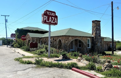
Arriving in Decatur, Texas, we made a "must-do" geocaching stop for a roadside attraction Americana history. "Petrified" (GC3X4ZF) is located at the Texas Tourist Camp Complex. From the historical marker: Local businessman E.F. Boydston (1888-1945) purchased this site, a former seed lot, in 1927 for $400. Recognizing a potential business opportunity in offering services to the traveling public, he built a wooden shed and gas station in 1927. Travelers were allowed to build campfires during overnight stays, and by 1931 Boydston added three wooden cabins with garages to the camp complex. The buildings were later faced with rock, and more cabins and garages were added in 1935. The original wooden gas station (photo at top of page) was covered with petrified wood in 1935 when the highway was widened and remained in operation by the Boydston family until 1988.


The Texas Lunchroom, a one room frame building, was built in 1929. Renamed The Texas Cafe in 1935 and refaced with stone to match the other buildings in the complex, it was enlarged to provide second floor living quarters. Popular with local high school and college students, as well as families and the traveling public, it was closed in the 1960's after a highway bypass built west of town diverted traffic from this area. The cafe re-opened in 1993. One of the few intact examples of tourist camps built throughout Texas in the mid-20th century. This property is significant for its association with the early development of automobile tourism.


Our last stop, also in Decatur, was for the geocache "Goin' to the Chapel" (GC198AR). The Episcopal Church of the Resurrection is the oldest original church building in Decatur. Consecrated by great missionary Bishop, the Rt. Rev. A.C. Garrett. Erected facing Main Street (2 blocks west of square) in 1889. Known as "the little church with the crosses", by 1912 it had deteriorated, but it was restored and moved facing Walnut Street.

In 1940 the building was sold and used as a mattress factory. Then it was rescued the same year and moved to this location, with the sanctuary placed symbolically to the east towards Jerusalem.


So that's it for today's roadtrip back home from Oklahoma to Texas. Thanks for riding along with us. Feel free to leave your comments and/or share our adventures with your friends. You can find us on most social media platforms:  FacebookMeWeParlerGabTwitterInstagramMAGAbook, and Reddit. Follow us on any or all of these platforms.

See you next time...

Saturday, December 19, 2020

2019-04-07: Geocaching Through Texas Independence History in Cemeteries, Memorials, and a Haunted House

Welcome back to AwayWeGo's Geocaching Adventures Blog. My geocaching name is AwayWeGo.US and these are stories about our travels around the United States. Like most weekends, today is another Sunday driving 360+ miles back to work day. I live in Killeen, Texas and drive down to Falcon Lake in the Rio Grande Valley where I work as a construction surveyor during the week.


After about 30 minutes of driving, my first stop was at an IHOP in Georgetown for breakfast. Before leaving, I grab the quick geocache just outside the parking lot (GC20T2K).

I decided to make a detour and attend this geocaching event in Victoria, TX. Heading down US-183, I made a stop at the San Pablo Cemetery in Lockhart for another quick geocache find (GC3QKN0). The San Pablo Cemetery has about 100 burials beginning in the late 1930's and is still in use today.

Stopping again at the Luling City Cemetery for another cache (GC3VCVD), you also get a view of a giant watermelon. In 1954, Hermon Allen, principal of the Luling Elementary School, proposed the idea of a celebration to honor the growers and promote the Luling watermelon market. The festival includes a watermelon contest for the largest grown. The biggest Black Diamond champion melon in the festival’s history weighed in 141 pounds. The event has grown so large that as many as 30,000 people have attended.


Arriving down in the town of Gonzales, TX, I stopped for a virtual geocache at the "Old Time Justice" (GCGB8Q). The jail was built in the 1880's and is now a museum. It wasn't open at this time. I'll have to return one day to take a tour myself. The photos of it look interesting.

There's a legend that while Albert Howard was waiting for the date of his hanging from his jail cell, he had a view of the clock tower on the courthouse to watch the time. Until the very end he swore of his innocents and said that the four faces of the clock tower would never keep the same time again as long as he was hanged. Over the years and several attempts to fix it, the clocks have never kept the same time.


Then there's also the "Immortal 32" virtual cache (GCG84Q). In February 1836, Colonel Travis sent a letter from the Alamo to all Texans and all Americans while under besiege by the Mexican Army. Only 32 men answered that call for Texas Independence and all 32 were from the town of Gonzales. This memorial and reflecting pond are dedicated to those brave 32 men who gave their lives in support of their brothers at the Alamo.


Well I made it down to Victoria, TX at the Ted B. Reed Park for the geocaching event (GC83TBD). There were eight in attendance and always good meeting other geocachers. I got to stay for a little while before hitting the road and continue south.


Just to the west outside of Victoria is my next geocache at the Coletoville Cemetery (GC4T8AB). Originally named Steiner's Settlement, after early German Carl Steiner. The settlement dates back to 1849. When an epidemic of diphtheria hit the German settlement, two of August and Thekla Spitzer's children died. Ten-year-old Henry and six-year-old Robert were buried by their parents in 1873 on this site. In May of 1873, the Spitzer's deeded the land to the trustees of the new school and evangelic German church of the German community of Steinerville. The community was later renamed Coletoville for the nearby Coleto Creek.

Continuing southwest into Goliad County, my next stop was at the La Bahia Cemetery (GC282ND). There you'll also find this significant memorial of the Texas Independence. After the battle of Coleto (March 19 - 20, 1836), where a Texas Army under Col. James Walker Fannin met defeat by Mexicans in superior numbers, the Texas soldiers were held in Presidio La Bahia, supposedly as war prisoners.

However, by order of Mexican Gen. Antonio Lopez de Santa Anna, 370 of Fannin's men were marched out and massacred on Palm Sunday, March 27, 1836. The wounded were shot one by one in the fort compound. Col. Fannin was the last to die. Because of their profession, Drs. J. H. Barnard, J. E. Field and Jack Shackelford were spared; about 25 men were saved by a Mexican woman, "The Angel of Goliad". Approximately 30 escaped by feigning death or by swimming the San Antonio River. The Texans' corpses were stripped and partly burned, but left unburied.

This atrocity three weeks after the fall of the Alamo gave Texans part of the battle cry -- "Remember the Alamo! Remember La Bahia!" -- under which decisive victory was won at San Jacinto on April 21, 1836. Gen. Thomas J. Rusk and the Texan Army afterwards marched here and gathered the bones of Fannin's men from the terrain. From Presidio La Bahia the remains were carried in procession to the grave, and there given a military funeral and burial on June 3, 1836.


Amid the cruelties of the Texas war for independence, one notable woman committed acts of bravery and compassion. Francisca Alavez ("The Angel of Goliad") accompanied Mexican Army Captain Telesforo Alavez to Texas in March 1836. In seven incidents between March and April, she intervened with Mexican troops under command of Gen. José de Urrea to help captured Texian prisoners at Agua Dulce, Copano, La Bahia, Victoria and Matamoros.

On March 20, Maj. William P. Miller and 75 men of his Nashville Battalion were captured as they unloaded their ship at Copano Bay. Alavez insisted that binding cords which cut off circulation be removed and food and water be provided. The men were moved to Presidio La Bahia at Goliad, where hundreds of Col. James Fannin's troops were already held after their capture at Coleto Creek. At least 342 men were taken out of the fort on March 27 and shot under orders of Gen. Santa Anna in what was termed the Goliad Massacre.

Alavez helped save the lives of many men, including 16-year-old Benjamin Hughes. Another Survivor, Dr. J.H. Barnard, recalled that she pleaded for their lives, helped sneak out some troops at night and hid some of the men. Her humanitarian acts included tending to wounds and sending messages and provisions to those still imprisoned.


Driving into Berclair, TX, I first arrive at the Berclair Cemetery for my next geocache (GC38VDX). Berclair was a ranching area when the railroad arrived in 1889. The name supposedly derived from the combination Bert and Clair Lucas, one of the ranchers. A hotel was built to provide housing for the railroad workers in 1887 and travelers once completed. A post office was established in 1889. The cemetery below covered in spring wildflowers.


One remaining attraction in Berclair is the haunted Berclair Mansion (GCYFCJ). This 10,000 square foot, 22-room mansion was built in 1936. Etta Terrell had the house constructed out of concrete and steel in an effort to "fireproof" it after her previous house burnt down. Etta and her four sisters lived in the house. Etta passed away in the house in 1956. The sisters remained living in the mansion until the last one passed away in 1968. The homes furnishings remain as the sisters left them with antiques dating back to the 1700's. Then in 1999, the heirs in the family donated the mansion as a museum to the Beeville Art Association.

The Art Association hired maintenance workers and landscapers to keep up the property. It was about this time when unexplained sightings and sounds started happening. Several reported seeing elderly women in the windows, waving to them. Volunteers for the museum say they’ve heard voices as well as doors closing in the otherwise empty house, for no apparent reason. And the Corpus Christi Spook Central’s supernatural investigation team has reportedly recorded at least 10 unexplained voices occurring in the mansion over the period of one night.

The house is open for tours the last Sunday of each month. We may have to come back for another visit one day.


Still having 3 hours of driving to go plus stopping at the grocery store and grabbing dinner, I made that the last geocache for the day. The was a lot of historical and interesting stops today that I didn't get to explore more. Just means I'll have to go back again one day.

Thanks for stopping by and I hope to see you again soon.  

Saturday, November 28, 2020

2019-03-09: A Packed Geocaching Roadtrip Returning from Minnesota to Texas: Day 3 in Kansas and Oklahoma

Hello again and welcome to Day 3 of the roadtrip returning from a business meeting in Minnesota and driving back to Texas. CuteLittleFuzzyMonkey (CLFM) and I took three days driving from TX to MN. Do we make it back to Texas today? Let's get going and see...

We left Manhattan, Kansas at sunrise and headed east on US-24 down the road into Wamego, KS. The town of Wamego is the birthplace of Walter P. Chrysler. You'll also find the Columbian Theater where you can see turn-of-the-century murals from the 1893 Chicago Worlds Fair. Probably the most popular attraction is the OZ Museum and all the Toto statues around town.


But what CLFM and I came for was our first geocache, a webcam geocache (GCPGXD). There were several webcams around town. We took our pose in front of the United Methodist Church.


Our final stop before leaving town was the Old Dutch Mill (GC83C3) virtual cache. Built in 1879 by Dutch immigrant John B. Schonhoff on his farm twelve miles north of Wamego, this old mill was used to grind grain into flour and cornmeal. In 1925, thirty-five team and wagons moved the windmill to this site. Each stone was taken down, numbered, and rebuilt exactly as the original. A bust of Ceres, goddess of grain, is set above the window. The mill is 25 feet in diameter and forty feet high.


Then we backtracked a few miles to Manhattan, KS because we forgot about the virtual geocache at the Kansas State Vietnam Veterans Memorial (GC6887).

Heading south on Hwy 177 for a few miles, we arrived at Konza Prairie Research Nature Preserve. The Konza Prairie located in the Flint Hills and is managed by Kansas State University as a long term ecological research site. This vast ecological system provides some spectacular views as you arrive at the visitors center. This was once part of the 2923 acre Dewey Ranch and was purchased in sections by the Nature Conservancy and Kansas State University from 1971 to 1979 for a total of 8600 acres today. The Konza Prairie was named after the Konza Indians. It also offers a trail system that can be combined for a 6 mile loop.

There was a virtual geocache and an earthcache along the highway (GCB63B, GC1DJV8). Then there was another virtual geocache (GC6E84) on the westside of the preserve as well as another virtual "Ashland Community" (GC6E86) outside to the north. Looking at the satellite imagery, it looked like we should be able to drive around the outside and get both of those. We really weren't up for the 6 mile hike at this time. So we gave it a shot.

Getting to the Ashland Community was pretty easy and we parked right out front of the historical building. Then following Google Earth, we continued down the muddy road around and into the westside of the preserve. Drove right up to within a couple hundred feet of the old water well. Sure made it easier than a long hike. And with the muddy conditions, I got to put the GeoJeep in 4x4 mode again.


Now jumping onto I-70 west for a short trip to the hill overlooking Fort Riley. This virtual geocache brings us to an Atomic Cannon (GC698E). Now I've never even heard of an atomic cannon! This is why I love geocaching! According to the historical marker at the site of the cannon: "This is one of only three atomic cannons in existence. The other two are located at Ft. Sill, Oklahoma and the U.S. Army Ordinance Center in Aberdeen, Maryland. This cannon was placed in service on November 17, 1952 and was deactivated in August 1963. Two 375 HP engines were used to transport the 42-foot, 280-mm cannon at 35 M.P.H. to the desired firing locations. The cannon can fire a projectile 11 inches in diameter for more than 20 miles. This cannon was never fired."

From the parking area, you can see the barrel of the massive cannon pointing outward. Standing next to it, it's like the huge cannons on a Navy battleship. Looking back downhill, that's CLFM nearby, I-70 going left to right, Junction City to the far left, and Fort Riley way off in the distant right side.


Driving on US-77 southbound in Herington, KS, we stop at the Father Padilla Memorial Park. There we find a not-as-big-cannon and our next virtual geocache (GCACE0). It seems like a pea shooter by comparison.


At the park across the street was this bench that was just calling out for me to take a photo!


Back to I-70 westbound, we take a ride over to Abilene, Kansas. There we found a large boulder which marks the northern terminus of the Texas Cattle Trail (GCGA9K). The plaque gives a little history, including the following, over three million cattle were delivered here. The trail was in operation from 1867 to 1871. The dollars brought in by the cattle trade and those hustling the cowboys gave Abilene the foundation of prosperity that still carry it today. The wild wild west was definitely here! Gunfights in the street, fistfights in the saloons, and prostitutes working the cowboys made for many wild nights. The upper class citizens of Abilene desired a more reputable image and laws were passed here that brought the cattle trade to an end. The cattle drives moved west to cities like Ellsworth, Hays and Dodge. Abilene continued to prosper without the cattle trade and is still a successful community.

Also in Abilene, you'll find the Dwight D. Eisenhower Presidential Library and Museum. And of course it's also another virtual geocache (GCBB05). President Eisenhower was born in Texas and lived there until age 1 1/2. His parents then moved back to Abilene. There he grew up and remained until he joined the military. Even though after his military and political career he moved to Gettysburg, he always considered Abilene his hometown and where his Library and Museum was built.


Next on our target list was a virtual geocache at the site of the Old Salina Brick and Tile Company (GC2E7C). We got the required bit of information needed for the answer and moved on.

Also located in Salina, Kansas is some aviation history (GC7B69P). In 1942 the Smoky Hill Army Airfield was constructed southwest of Salina. When the base closed in 1967 it left Salina with one of the largest Municipal Airport runways in the world. Turns out that wasn't the end of Salina's aviation story. For many years aircraft parts were built in several of the old base buildings by several familiar manufacturers. In more recent years it has become home to K-State Polytechnic with pilot programs in flight including a unmanned flight program. Military aircraft are still a common site at the airport with several reserve units having training facilities on the airport properties. 38 years after the closing of the military airfield a record breaking round the world flight took off (02/28/05) and landed (03/03/05) on the historic runway. The "Global Flyer" was quite an event and this monument is the centerpiece of a newly dedicated park with extensive history of the Airfield.


Heading south from Salina on I-135, we go down a short drive to Coronado Heights Park (GC3483). Located up on a hill overlooking Saline and McPherson Counties. Coronado Heights receives its name from Spanish Explorer Francisco Vasquez de Coronado who visited central Kansas in 1541. He was looking for the Native American community of Quivira where he was told "trees hung with golden bells, and pots and pans were beaten of gold." Coronado didn't find his gold.

In the 1930's, the Works Progress Administration built a picnic area and castle like building out of Dakota limestone. There was also a traditional geocache hidden a short walk down one of the trails (GC1TNG5).


Continuing southbound on I-135, there's a roadside attraction photo opp and our next virtual geocache (GC348A). Though I don't know how I missed taking a photo myself. So I'll use CLFM's photo. This used to be the "Happy Chef" which stood outside the Happy Chef Restaurant in McPherson. Someone bought it and moved it here. Now it looks like Mr Moneybags from the Monopoly game.


On the way to Canton to pay respects to Edgar Miller, we found two geocaches (GC824R0, GCG6V6) on the road to and in the cemetery. Edgar was an 18 year old ranch hand who bravely rode across the prairie to get help for his bosses wife who was very ill. He was captured by Cheyenne warriors who tortured, scalped, and murdered him, leaving his body in the weeds. For the complete riveting story, visit the Santa Fe Trail Research website.


Then there's the "Nothing But Blue Sky" virtual geocache in Newton, KS (GCAE93). Located in Centennial Park is this huge piece of artwork sculpture created by three artists.


Finally making it down into Oklahoma, we make string of geocaching stops in cemeteries to claim new counties. One cemetery geocache in each county of Alfalfa (GC2BFZ3), Grant (GC3NNQM), Garfield (GC71GHP), Kingfisher (GCMJND), Blaine (GC4J0Y3), and Caddo (GC7KGVK).

By now it's getting late, already dark, but we're still going on. Also in Caddo County, in the town of Anadarko, OK, we stop by the former Rock Island Railroad Depot (GCGA01). Built in 1902, it is now a museum and a virtual geocache. The museum was closed at 9:30 PM while we were there, but I did manage to see the cool old fire truck parked out front.


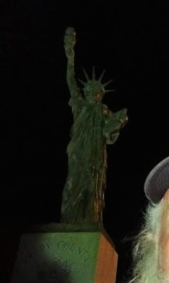
Moving down to Grady County, we get our last cache for the day. A virtual geocache for another one of those miniature Statue of Liberty monuments (GCFC05).


We finish the day near midnight finally getting some sleep down in Lawton, OK. Twenty-eight geocaches, about a dozen new counties, and nearly 18 hours later I'm exhausted! But it was a great day for geocaching and sightseeing through history.

Until tomorrow... ZZZzzzzz........
Saturday, November 14, 2020

2019-03-03: A Packed Geocaching Road Trip from Texas to Minnesota and Back! Busy Day #2 in OK, KS, and MO.

"OK campers, rise and shine, and don't forget your booties because it's COOOLD out there!" (a little Groundhog Day humor there) Are you ready for day two of our road trip? The temperature is a whopping 1 DEGREE outside this morning with fresh snow on the ground! CLFM and I were up and out at sunrise ready hit the road. Well he more than I since I'm still dealing with a pinched nerve in my lower back and not much sleep because of it.


In case you missed Day One of our roadtrip, you can catch up here. We begin today still in Oklahoma. In the town of Perry to be exact. First geocache on the agenda is another one of those puzzle caches that I'm clueless about. But CLFM solved it and we make the find for "Wrestling Park" (GC73VWX). I think we were the first ones downtown this early Sunday morning and I felt kinda bad putting the first set of tire tracks through the fresh snow cover.


Now back to I-35 northbound only to exit back off a few miles up the road for a virtual cache drive-by. "Keep a Truckin" (GC4B0F) is a very unique roadside attraction and billboard for a trucking supply company. What I didn't realize until now was that I had seen this truck several times before passing through while I was a trucker myself from 2007-2010. I started geocaching back in 2006 and don't know why I never logged this virtual geocache as a find before.


Well we finally made it to Kansas! And after a stop at Walgreens to pickup some Aleve, my back is starting to feel a little better. Not much, but a little bit.

First on the list in Kansas is another quick drive-by virtual geocache at the Mulvane Historical Museum (GC66E3). We found the caboose with the required answer (which I have blocked out), snap a photo, and on to the next one.


Now one of the great things about geocaching and driving the back roads is that you never know what you might run across. This next one was NOT on our planned to-do list. We were driving down this back country road outside of Derby, Kansas on the way to grab another virtual. I spotted this metal sculpture, yard art of a bull mounted on 4-wheels, sitting atop a fence. It gave us a chuckle and I just had to make a u-turn for a photo. And wouldn't you know there was also a geocache there too (GC2RQM2). Sorry for the bad photo. This was taken through the window while CLFM was getting the cache.


So that virtual geocache we were headed to turned out to be some more yard art metal sculptures. "Jurassic Art" (GCB0CA) was probably the largest collection and best displayed yard art I've seen. Not pictured was a life size knight in shining armor with sword drawn fighting an even bigger winged dragon. But my favorite was the parade of ghost riders on Harley's!


Our next stop getting closer to Wichita, Kansas was an Earthcache at the Butler Artesian Well, a natural spring water well (GC1RY3Z). Although with the single digit temperatures and all the snow on the ground, there wasn't much to see.

Next up is a string of virtual geocaches in and around Wichita. "Hold the Anchovies" (GC85C9) is the beginning of one of the largest pizza chains in the country. This little brick building on the campus of Wichita State University is the very first Pizza Hut location.


And then there was this unique statue (GC7B63). There's no plaque or historical marker placed there to tell the story. But it goes along with what the soda counter represent. You can read the entire story at the geocaching page. In summary, on July 19, 1958 at the Dockum Drug Store sit-in was one of the first organized lunch counter sit-ins to protest segregation.


The Chisolm Trail was a trail used after the Civil War to drive cattle from Texas up to the Kansas rail yards heading east. The next virtual geocache is for a monument (GC9F39) that reminds us of the history of Wichita and those dangerous cattle drives.

And last but not least was the Lonely Steer (GCB06A). A statue of a Texas longhorn bull, just one of two original bull statues built in the 1970's. They were separated a few years back because of some construction and this one ended up out front of the high school as its mascot.

Back on the Interstate 35 northbound, we stopped at a rest area for some gas, coffee, and a cache for Chase County (GC5QCMP). Then a quick stop for a cache in Lyon County (GC28NF4).

In Topeka, this next one was another virtual geocache (GCB30E). Can't show you the photos because they give the answers. But I will describe it from the CO's perspective. He's an Iraq War Veteran. "The aircraft in question has quite the history. It does not list the accomplishments it has endured but it holds 14 world records in various areas such as longest endurance flight and highest altitude. I am a member of one of the units that used to fly one of these very dependable and durable aircraft. We now use a more advanced aircraft that has more room and greater speeds as well as being more mission capable. If you stay long enough, you may see us up flying around."

Also in Topeka was the "Gone But Not Forgotten" virtual geocache (GCG3ZN). This memorial was dedicated to those who served and gave their lives during the Vietnam War.


Our last two geocaches in Kansas were in Atchison, both virtuals, and both in the same neighborhood! One at the birthplace of Amelia Earhart (GCBA15). She was a pioneer in aviation and the first woman to fly solo across the Atlantic Ocean. She went missing trying to cross the Pacific and was never seen again.


The other house in the 'hood was the "Sallie House" (GC7B8Z7). The most haunted house in Kansas's most haunted town is none other that The Sallie House. The home earned its nickname after a 6-year-old died in the home during a failed appendicitis surgery in the early 1900's. Then it gained notoriety in the 1990's, when a couple renting the home reported harmless pranks being played on them, which eventually turned malicious and violent. After consulting a psychic, it was discovered that Sallie wasn't the only ghost haunting the home, but a middle-aged woman as well.

One more geocache today at the "Loess Is More" Earthcache (GC64KXZ) in Rock Port, Missouri. It was a long day, a long drive, freezing cold, and my back was still hurting. But we did find 18 caches for the day and saw a lot of history. We ended in Omaha, Nebraska for the night. And we start right there first thing in the morning. See you then.

Tuesday, October 27, 2020

2019-02-06: Finally Completing the Texas Counties After 13 Years!

YAY!! It only took me 13 YEARS to complete!! Being a Florida resident, we were traveling around in an RV and when we got to Fort Davis I remembered my sister telling me about this Geo treasure hunting game. Well our DataStorm satellite gave me coordinates wherever we were parked. So without a GPS, my son an I made 3 attempts hiking the trail before finding the cache on April 18, 2006. You can read all about that in a blog post here: http://awaywego.us/adventure_archives/04-19-06.html


Continuing West to California, north to Alaska, east to Maine, and then back to Florida, I would not see another Texas cache until July 2007 when I became a truck driver. Picking up some caches here and there as long as I can find Big Rig friendly caches, my last Texas cache as a truck driver came in April 2010. That started a dry spell as I would not step foot in Texas again until November 2015. (That's all in my original blog linked above.)

When I first arrived back in Texas this time, my wife and I were in Jasper (East Texas) for 6 weeks until her company transferred her to Lubbock. We were there for 3 months and then transferred again to Crane for 18 months. From there she went to Killeen. My new job had me working in West Texas, then down to the Rio Grande Valley. So I pretty much covered the state! (You can read all about that in this blog.)

I had the final 3 Texas counties: Hood, Dallam and Sherman. Hood was SW of Fort Worth and just a few hours away. But Dallam and Sherman Counties were WAYYY up in the top west corner of the panhandle. We just did not have time for them on that caching run while we were in Lubbock. I knew they would be haunting me and I almost had to leave them behind.

I finished surveying the wind farm project in the Rio Grand Valley (yeah my work involves a GPS also!) on January 25th and they wanted me to start in Missouri last Monday on the 28th. YIKES! No way I can grab those unless I took the REALLY long way around. Well as luck would have it, the last minute they told me to hold off on going to Missouri. So I decided I'd better run up there quick while I have the chance before they assign me my next project location.

A couple days ago I hit the road. Going north up I-35, I stopped for gas in Alvarado, Texas. Nearby was a large cemetery with two geocaches. I found them both (GC5ZMG5, GC5QRGJ). I mean you can't pass up a cemetery cache when you're that close right!

Then I finally arrived in Hood County and Acton Cemetery. Acton had four caches, one of which was for a famous resident; Elizabeth Crockett (GC6XKHC). Acton Cemetery is also the location of Acton Historical Site which is the smallest Texas State Park. The park basically consists of the grave of Elizabeth P. Crockett (1788-1860), widow of Alamo Hero David Crockett, and two of his children. In 1911, a statue and monument were erected to her memory and made a state park.


Acton (formerly called Comanche Peak) was named in 1855 by C. P. Hollis, the first merchant in town. In spite of the early name, Acton had few Comanche raids. After erecting a building for church and school, early pioneers selected this plot for a cemetery. The first person buried here was Mrs Wash Hutcheson in 1855.

A few more quick caches along the roadside before arriving up in Dalhart, Texas for the night and checking into the hotel.

Yesterday morning I'm up and out just before dawn. Dalhart has some creative caches in town and I wanted to get to them before the local muggles would hinder my search. The geocaches were called "The Valve of Life" (GC4YDEY), the "Denver and Rock Island Switch" (GC55P4B), and the "Dalhart Volunteer Fire Department" (GC58BMN). Combined they have well over 1000 visits and over 600 favorite points! And they get me one of my last two remaining counties!

Now the road to get to the tri-state corner, which I'll get to in a moment, goes into New Mexico before back into Texas. I already had that county for New Mexico, but I didn't want to pass up this cemetery. Clayton Cemetery contains the grave of "Black Jack" Ketchum (GC1KD22). Thomas Edward Ketchum (October 31, 1863 – April 26, 1901), was an ordinary cowboy and cattle driver who later turned to a life of crime. Black Jack Ketchum became one of the most famous outlaws in the region. He was captured when he single-handedly attempted to rob the same train again at the same place and in the same way that he, his brother Sam and others from the gang had robbed it just a few weeks earlier.

The train conductor, Mr. Frank Harrington, saw Tom approaching the moving train. He recognized him, grabbed a shotgun, and shot Tom in the arm, knocking him off his horse. The train continued, and the next day a posse came out and found Tom beside the tracks, badly wounded. He was transported to medical facilities at Trinidad, Colorado and his right arm had to be amputated. He was nursed back to health and then sent to Clayton, New Mexico Territory, for trial. In 1901, Black Jack was sentenced to death and hanged at Union County Court House for all his crimes and his last attempted train robbery. Black Jack's last words were: "I'll be in hell before you start breakfast, boys! Let her rip!"


Next up is a physical cache at the NW corner of Texas bordering New Mexico only (GC2VPKZ). You don't really notice it on most maps because it's just a slight overhang of about a mile where New Mexico goes over top of Texas before bumping into Oklahoma. So you have that marker and then about a mile to the east is the tri-state marker connecting Texas, New Mexico, and Oklahoma. And that is a virtual geocache pictured below (GC9374). I just had to wear the black hat for that one!


So now I'm kinda zig-zagging between Texas and Oklahoma picking off the Oklahoma border counties as well. A quick roadside cache (GC4J62V) and a cemetery cache (GC146NC) for Cimarron County. Then I dive down into Sherman County, Texas for my final of the 254 Texas counties (GC4JYTD)! WOHOO!! My second completed state and it ONLY took 13 years to do so! LOL

Picking up seven more cemeteries and two quick roadside caches in Oklahoma before I get to the Shattuck Windmill Museum virtual geocache (GCGBM4). There are windmills of all kinds dating back to the 1800's. A whole lot smaller than the 300' turbines of today!


A few more quick caches yesterday after that and I found the nearest hotel just as it was getting dark to stretch out and relax.

This morning I grabbed a cache (GCMHHX) here in Altus, Oklahoma for Jackson County before crossing the border into Texas. Continuing southbound on US-281 towards Killeen, TX, I spotted this world's largest rocking chair and a virtual cache (GCGYEB).


One more geocache to show you on my drive back home today. This simple bird house looking geocache was easy to find (GC6Q8PT). The tricky park was getting it open to sign the log. After a few minutes I figured it out this gadget cache and had my hands on the prize.


So I completed my Texas Counties on February 5th, 2019! YAY!! That brings my total counties to 1024 with Texas and Florida completed. Hopefully by years end my job transfers me to a solar project in Virginia where I can work on another state. Stay tuned for what's coming next...